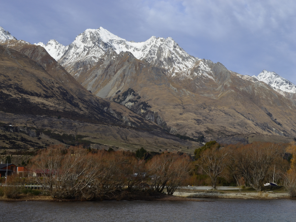
Thursday, 31 January 2013

The wettest place in New Zealand?

As we've been working in Queenstown for the last couple of months and have been caught up in the tail end of the ski season, we've wanted to make a conscious effort to keep up with our travels on the South Island, even if it has to be in smaller day trips. For one of our first trips outside the Queenstown region, we managed to book a day cruise on Doubtful Sound through Real Journeys, as they're the main company that run cruises in that part of Fiordland, plus we were able to take advantage of an offer where Queenstown "locals" can get a discount taking the price from $265 NZD down to $145 NZD! It's still a reasonably expensive cruise compared to the ones at Milford Sound but we've heard that it's a much better experience and having already been to Milford Sound five years ago, we though it would be interesting to do a comparison.

On the left iconic Mitre Peak rising 1,692m from the fiord at Milford Sound
There are several reasons why Doubtful Sound is considered a better experience for visitors, namely the shear inaccessibility of the area - an untouched wilderness that can be enjoyed in any season and the sense of grandeur that you get when visiting a fiord which is ten times bigger than Milford Sound, making it the second largest fiord in Fiordland National Park!

Starting our Doubtful Sound adventure, we needed to drive to the small township of Manapouri (population of 210!) in the southwest corner of the South West. Driving from Queenstown down to Manapouri via the Southern Scenic route, it roughly took us 2 hours (172km) following State Highway 6 and then picking up State Highway 94 at Mossburn. Lake Manapouri resides within Fiordland National Park and the Te Wāhipounamu (the place of greenstone) World Heritage area. As mentioned previously, Manapouri is largely used as a starting point for cruises to Doubtful Sound, and getting to the fiord is an an adventure in itself, as it can only be accessed by crossing the lake as part a tour, following by a coach ride over the Wilmot Pass through some dense cool temperate rainforest to Deep Cove.

Manapouri was the site of New Zealand's first major environmental campaign, when in 1959 it was proposed that the lake level should be raised by 30m for the use of the West Arm hydroelectricity power station. If this had gone ahead then the lake's famous wooded islands would have disappeared and the fragile shoreline beech forest would have been lost. This resulted in a decade-long nationwide protest with a petition gathering 265,000 signatures (almost 10% of voting-age New Zealanders at the time). The end result was that the power station was still completed, but without any alterations to the lake's natural level, making it a major milestone in the history of New Zealand's environmental protection. At present, the lake's levels are carefully controlled to be close to natural fluctuations. Preserving the natural environment is still as prominent a concern for Kiwis today as it was 70 years ago with the current controversial proposals to build a tunnel to Milford Sound through Mt Aspiring National Park gaining a lot of negative publicity...

Lake Manapouri is the fifth largest lake and second deepest in NZ with four major arms; North, South, West and Hope as well as small indentations at Calm Bay and Shallow Bay. The lake has 32 islands, of which 22 are wooded. The largest island is Pomana Island, which lies close to the centre of the lake. Other notable islands include Holmwood, Rona and Mahara Islands. The Waiau River is both a natural inflow and outlet for the lake, flowing northeast of the lake from Lake Te Anau. The lake's catchment is also served by the slopes of the Kepler Mountains, Turret Range and Hunter Mountains that surround all but the eastern shore of the lake.

According to Māori legend, Lake Manapouri was formed from the tears of two sisters, Motorau and Korowae, daughters of an old chief in the region. The name Manapouri is Māori for "sorrowful heart", although, due to a cartography error the original Lake Manapouri was North Mavora Lake, which lies between Lake Te Anau and Wakatipu. The lake's original name is believed to have been Roto-ua (Rainy Lake). Local Māori also called Lake Manapouri, Moturua which means "many islands". 

It wasn't the best start to the trip as we arrived to a drenched Manapouri (the weather forecast for Fiordland for the weekend was for 100mm of rain) and it was already getting dark at 7.30pm as there were many heavy clouds with the rain thrashing outside.When we woke the next morning, we were surprised to discover  it had been actually snowing over night, although the weather report was for snow down to levels of 400m.

Kepler Mountains to the northwest of the lake 

Clouds looming over the Hunter Mountains

It was a wonderful sight seeing the mountains after the storm


In our usual style, we arrived fashionably late for check-in at Real Journeys office by the entrance to the Wairau River, although it was still another 15 mins before we would actually board our vessel (the MV Titroa) to take us across the lake.

The initial cruise across Lake Manapouri took us roughly 45 minutes, passing many of the bush clad islands the lake is famous for, however, it was raining/sleeting quite steadily and the visibility was pretty poor so I was a little concerned how much we would be able see at Doubtful Sound. I was particularly keen for reasonable weather as I was testing out the optical quality of a Sigma 18-200mm f/3.5-6.3 DC telephoto zoom lens that I borrowed from work!

Lake Manapouri isn't know as Moturau (many islands) for nothing

Passing Cone Peak (1,495m) and the South Arm of the Lake


Beanies, scarves and waterproof jackets are the order of the day


Evidence of landslides on the side of the mountains 


Titiroa is also a prominent mountain in the Te Anau Basin area
As we cruised around the North Arm, we slowed down past some stunning unnamed waterfalls that the captain of the MV Titroa, claimed for himself  - I'm pretty sure he called them "Māori Rowan Falls" but I would be interested to find out if anyone actually caught what the actual name was!

The mysterious but stunning falls on the North Arm of the lake


Arriving at the tip of the West Arm of the lake we disembarked from our the vessel by the Manapouri Power Station. From here we would take the next form of transport, a coach over the Wilmot Pass to take us into Deep Cove at Doubtful Sound.

The 671m high pass was built in the mid 1960s to provide heavy equipment access for the construction of the power station. According to the coach driver, the Wilmot Pass cost $2 for every cm layed, by my reckoning the 22km road must have cost $440,000 to build, making it one of the most expensive roads built in New Zealand at the time. Floods, snow, mud and landslides lengthened the initial project from 12 months to 2 years!

The drive over the Wilmot Pass (named the explorer Ernest Wilmot) was made especially "interesting" by the  persistent snow fall and our coach was preceded by a snow plow clearing at least 6 inches off the road! It sounded like we were in for a real treat at Doubtful Sound with the freakish weather we were having.

It was a beautiful sight seeing all the snow on the Wilmot Pass
Silver beech (tawhai) trees dominate the forest on the pass

Not the sign you want to see coming down the other side


Fiordland National Park is the largest of New Zealand's national parks - an area roughly the size of Wales at 1.25 million hectares or 3 million acres, and Doubtful Sound lies in the heart this designated World Heritage Listed area - Te Wāhipounamu. Fiordland is considered New Zealand's rawest wilderness area with jagged forested mountains, intersected by numerous deeply recessed fiords in some of the most inaccessible parts of the country.

It also happens to be one of the wettest regions in New Zealand. Moist westerly airstreams fan across the Southern Ocean and South Tasman Sea, before crashing into the high landmass. The average rainfall increases the further West you move into Fiordland, for example:

  • At Manapouri the average rainfall is 1,200mm rain a year 
  • At the West Arm of Lake Manapouri the average rainfall is 3,500mm rain a year 
  • At Deep Cove the average rainfall is 5,300mm rain a year or the equivalent of 25ft!

It's not all bad news though, as the area has numerous amazing waterfalls and forests to enjoy, thanks to the 180 days worth of rain in Fiordland each year.

Arriving in Deep Cove for the start of our cruise, our boat for the Doubtful Sound was the Patea Explorer, an impressive catamaran with three decks and two covered areas at the stern. As we headed slowly towards the mouth of the Tasman Sea, the cruise was estimated to take 3 hours to get around the fiord, as Doubtful Sound is three times longer and ten times larger than it's better known cousin Milford Sound. However, it's not the largest of Fiordland National Park's 14 fiords - that title belongs to Dusky Sound.
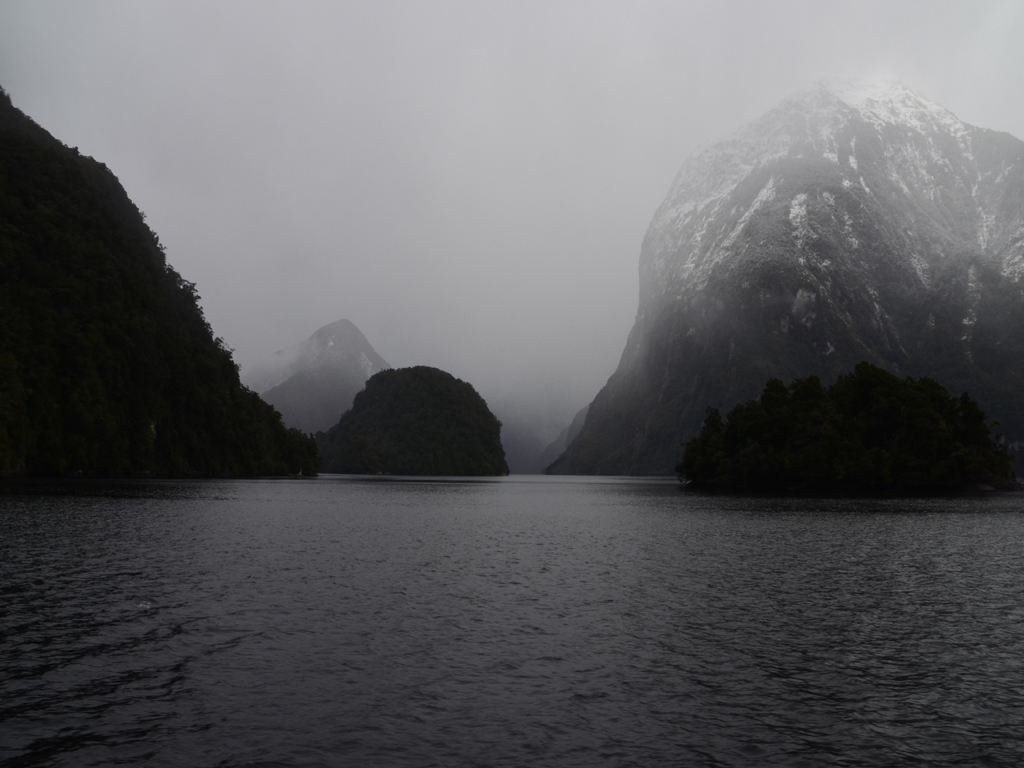
The fiord looked moody and dramatic in the heavy mist

Passing the end of Elizabeth Island (Taipari Roa) in the foreground 

Looking up the Crooked Arm at Kellard Point


According to Māori legend, Doubtful Sound and the other fiords were created by a godly figure (Atua). Tu-Te-Raki-Whanoa, the creator of the fiords wanted to create long winding inlets that would serve as refuges from the stormy seas. When Tu crafted Doubtful Sound (Patea) he was assisted by four young sea gods named Taipari, who created the arms - First Arm or Taipari-poto (short), Crooked Arm or Taipari-nui (big), Hall Arm or Taipari-row (long) and Deep Cove or Taipari-tiki (little).

It was absolutely freezing on the top deck if you can't tell.


New Zealand is fabled for having unpredictable weather and four seasons in one day, and we literally had one of those days! We had rain, snow, sleet, blustery breezes, blue skies and the sun all rolled into one - it certainly made it challenging to get photos without getting droplets all over the Sigma 18-200mm f/3.5-6.3 DC camera lens especially as the autofocus feature wasn't compatible with my Nikon D5100. But a plus side of the stormy weather we're experiencing was that there were lots of small waterfalls cascading into the fiord due to all the rain water running down the sides of the mountains. Not to mention the snow topping all the peaks, making it an even more beautiful sight that usual.


Once we reached the entrance of Doubtful Sound we couldn't venture any further as the swells were quite rough on the Tasman Sea.

The Te Awaatu Channel between Bauza and Secretary Islands


The first European to discover the fiord was Captain James Cook during his search for the "Great Southern Continent". Doubtful Sound was originally called Doubtful Harbour, as when Captain Cook observed the fiord from the coast in 1770, he was "doubtful" whether the winds would be sufficient to manoeuvre the Endeavour back out to sea from the fiord. It was reported that the scientists on board wanted to land but Cook wouldn't take the risk. Twenty-three years later the outer reaches of the fiord were explored by a Spanish expedition led by the Italian explorer, Alessandro Malaspina.

In terms of wildlife spotting, were a little unlucky not to see Fiordland crested penguins (tawaki) as their breeding season offers the best viewing opportunities. We cruised passed Rolla and Shelter Islands but they were nowhere to be seen...

This is the closest we got to seeing a Fiordland crested penguin


However, we did see some bottlenose dolphins (which are the most southernmost in the world) and a lonesome New Zealand fur seal relaxing on the rocks by Marcaciones Point where a plaque dedicated to the Spanish explorers commemorates Malaspina's expedition. No other part of New Zealand has a such collection of Spanish place names as Doubtful Sound!

A lonesome fur seal at Marcaciones Point on Bauza Island 


Sadly no penguins were hiding in the Shelter Islands to the left 


This hut in Blanket Bay is the only building in Doubtful Sound


As we turned back from Te Awaatu Channel, we took a detour down the atmospheric Crooked Arm, which is actually longer than Milford Sound itself!


What was really impressive about some of the mountains in the glacial valley was that the forests on the mountainsides had been able to develop right down to the water's edge, even in the absence of deep soil development. Underneath the interlocking root systems of trees lies smooth, solid rock hence why the tree line lies so close to the water's edge. Tree avalanches are common in the area, usually triggered by high rainfall or heavy snow as evidenced by the "scars" or bare patches of rock where the fiord has claimed the trees. An earthquake measuring 7.2 on the Ricther scale struck Doubtful Sound back in 2003 and caused approx. 260 tree avalanches, however, a much stronger earthquake was recorded in 2009, which measured 7.8!

Before we finished our cruise, we had one last opportunity to get an up close and personal view of the stunning Lady Alice Falls, Fiordland's tallest waterfall!


As we pulled back into the wharf, our coaches were ready to take us back up the Wilmot Pass but not before we stopped off at the top the pass to get a view overlooking Deep Cove and to more importantly, to have a play in the snow!


Although the visibility was poor, it's still a great view into Deep Cove 


Lizzie getting carried away in the snow!


Before we made our return journey across Lake Manapouri, we had one last treat in store - a journey into the heart of the granite mountains to the underground power station! Lake Manapouri is the site of the largest hydroelectric power station in New Zealand with its generating units housed in a cavern excavated from the rock 200m below the lake. Having already had the pleasure of doing a tour of the Dinorwig Power Station in Wales more than once, I was ready for another marvel of engineering - can you detect the hint of sarcasm!?

To get to the underground machine hall of the power station, our coach drove through a spiral tunnel carved 2km into the mountain. When power station was first constructed trucks had to reverse down the tunnel when delivering machine parts (as there's no turning room at the end), which sometimes took up to 12 hours! The power station was originally built to supply the power requirement of Comalco Aluminium Smelter, 171km away at Bluff. However, in 1963, the New Zealand Government had to take over the construction costs of building of the power station as Comalco could only finance the smelter.

The Manapouri power station machine hall


The station utilises the 230m drop between the West Arm of Lake Manapouri and Deep Cove 10km away to generate electricity. Building the power station and constructing the road over the Wilmot Pass was dangerous work, and it tragically claimed the lives of 16 men whose names are on a memorial plaque on the rock that forms the power station they helped create. I guess in a funny way if the campaign to prevent the construction of the power station was successful then Wilmot Pass possibly wouldn't have existed and Doubtful Sound would be even more inaccessible today than it already is for tourists.

Our verdict on the trip was despite the slight worry about the weather, having all the overnight snow made it a better experience than when we went to Milford Sound five years ago. As to whether it would be better than Milford overall on a different day, the jury is open...The Doubtful Sound experience is much more magnificent in terms of a cross section of wildernesses - going from a lake to an alpine pass and a vast fiord. However, you don't get the imposing Mitre Peak or the scenic journey up the Milford Road...

Monday, 24 December 2012

It's not what you know, it's who you know

This blog post has been written an unintentional follow up to my original post about working in New Zealand. One of the biggest attractions about working in Queenstown is that it's the place to be in New Zealand; it has stunning mountain scenery, year-round adventure activities and hedonistic nightlife - all in all its a town driven by tourism.

So, apart from the main cities (Auckland and Wellington) and regional seasonal work, Queenstown is a good place to look for temporary work. The best time to look for work is before the two main seasons, summer and winter (with spring and autumn being the shoulder seasons), where you can get jobs such as working for local adventure activity companies, jobs at Coronet Peak and the Remarkables ski fields, or even general work in the hospitality sector. It is possible to find other jobs in the town during the main seasons because of the high turnover of backpackers passing through with working holiday visas. As long as your prepared to work unsociable hours for the minimum wage, there are plenty of jobs in bars, restaurants, convenience stores, retail shops, etc.

Personally, I've found it quite a difficult experience to find work in Queenstown having dropped off lots of CVs into shops, hotels, the local cinema - basically anywhere which had a job going and for work which isn't particularly challenging, especially when it would be easy to pick up quickly with some on-the-job training. So far I've had trials at a pizza restaurant and a convenience store both with their own "interesting experiences".

My first trial was at The Cow pizzeria on Cow Lane, working as a kitchen hand. I found out that there was a job available through the hostel we were staying at - this can often be the best way of finding out about jobs in Queenstown, through word of mouth as well as checking out the Lakes Weekly Bulletin, and job search websites such as Seek or Indeed. Having arranged a trial with the chef, I spent three hours in the kitchen rolling out pizza bases till my arms ached, as well as being shown the ropes by the current kitchen hand. Having impressed enough to be asked back the next day, I was given the impression that the job was mine for the taking as I was asked to bring my IRD number (for paying tax) and bank details with me. Returning to the kitchen the following day it was another arduous exercise of making pizza dough and rolling out bases to within an inch of their life. However, after three hours I was told that I could go as the restaurant had some more people they wanted to trial and they would be in touch soon having taken my contact details - a complete turn around from the day before when I thought I had bagged the job!

The Cow restaurant on Cow Lane


It came as no surprise that after a week I still hadn't received a phone call, not even to say "thanks, but no thanks" - a text message might have even sufficed! So I decided to go back to The Cow to get an explanation, however, I was fobbed off with a convenient excuse from the main chef that they were still trialling another person and that he had lost my phone number but would let me know soon. What really drives me mad is when people can't even be up front about not wanting you for the job. If the chef had at least been honest and said "I'm sorry but you're not the right person for the job" then that would have been fine, it's worse when people string you along and toy with your emotions especially when you're dependent on finding a job to get some stability. To be fair I'm not sure if I would have been suited for the job as it was quite hectic with all the tasks that needed doing, and in all honesty the kitchen hygiene standards left a lot to be desired, with the regular kitchen hand eating the soggy salad with his fingers before preparing the next set of pizzas. The boards that the pizzas were served on weren't even washed between servings, just the remnants of the last meal scraped off, and last but not least the gluten free pizzas were just frozen pizzas bases!

My other experience was at one of the City Express convenience stores in town. The job was advertised in store and the manager was keen to meet potential applicants after screening their CVs. Personally, this was my least preferable choice of job as the hours were largely unsociable and the store manager was very condescending at the best of times. Having worked a couple of 3pm - 1am shifts, to say it was quiet would be an understatement  - it was pretty much the ghost shift! However, this is possibly due to the lack of people visiting Queenstown because of the shortfall of snow throughout the winter season, which has had a big impact on all the ski fields and local businesses, but that's another story...

City Express on Church Street a.k.a. the Kwik-E-Mart


Its a pretty soul destroying experience working into the early hours of the morning on your own whilst the rest of Queenstown is having fun, but needs must! Every so often you might get a group of customers break up the monotony but as the evening progressed they'd be getting more and more wasted. Pretty much all the products in the store are unashamedly overpriced (although the prices aren't on display so it's like your stereotypical corner shop from the 90's!) but the tourists who use the store are too lazy to shop around and are frivolous with their money as they're on holiday. The tedious list of staff rules were a joke, with one particular rule stating "No friends or family to visit whilst you are working".

The abridged version of the prison staff rules - part one...


...part two of the grammatically inconsistent nonsense


I found out quite quickly how serious the company were on enforcing the rules when Lizzie dropped into the store to say "Hi" on her way home from work one evening, after about 10 minutes I got a phone call from the store manager explaining that the security company had called him to say there was a person hanging around by the checkout for too long - FFS talking about taking surveillance to the extreme! I though the security cameras were there to keep an eye on the customers not the staff! In all seriousness I felt that I was being constantly monitored with 7 cameras in the store, especially when I had to open up the store at 7.00am one morning and I got a text message from the store manager at 7.02am trying to find out why the store wasn't open despite having just putting my key in the door...

Fortunately, I have managed to find a better job in the meantime but when I think about the store manager and how he had penny-pinching down to a fine art, with cost cutting measures and a massive mark-up on the goods in the store, it reminded me of Apu from The Simpsons and his Kwik-E-Mart. Especially, when the store manager was justifying that you could still sell microwaved frozen pies which had been put under a heated lamp for 10 hours because "it's what they do in Mobil garages!"

The next time you're tempted by a convenience store pie, think about how long it's been sitting in the heater!

Continuing back on the theme of looking for jobs, one of the best sources of local information is the Lakes Weekly Bulletin, which is published every Monday around 1.30pm on the website and is available in print every Tuesday. However, it's best to be on the internet waiting for the online edition as it seems quite a lot of people are all searching for the same jobs and it can pay to be the first off the block with casual work. Quite a lot of the jobs advertised will be part-time (often 20-30 hours) so you might find yourself trying to juggle two part-time roles at once or even working for accommodation if you're staying a hostel.

Quite often I've found prospective employers don't have time to read through reams of résumés/ CVs very thoroughly so it's worth pointing out your relevant experience and skills when dropping off your CV. Also, if you haven't heard back after 3 or 4 days it's always worth doing a follow up to keep your submission fresh in the employer's mind, plus it makes you seem keen and eager for the job, but you can also come across as annoying if you don't get the balance right.

There are a number of job agencies in Queenstown, however, we've really had mixed experiences with these as they often talk the good talk but rarely go out of their way to push work in your direction. I guess it's because so many people register with these agencies when they first arrive in town that you're often just a name amongst hundreds of others. I got a phone call from the Queenstown Job Agency the other day, 6 weeks after I first registered with them asking if I was still looking for work! What a joke! If we hadn't found a job by then we would have tried our luck back in Wellington or Auckland instead - it's such a waste of time for everyone involved that it takes so long for recruitment staff to actually get back in touch with you just to find out if you're still looking for a job...

However, sometimes finding a job can come down to who you know more than based on your own merits, as I found when I mentioned to a housemate that I applied for a job at a zipline eco-tour adventure company. He kindly offered to put in a good word to the course manager as he was mate, but I felt if I was the right person for the job then I should be offered the job based on that and not anything else. I also had a very different experience when I applied for video editor role at local sky diving company called Nzone. Not only didn't I receive any sort of acknowledgement to confirm receipt of my application (which was submitted a week ahead of the closing date) but also I had to call the General Operations Manager, Jon Rowe, to find out that my application hadn't been considered properly because of my work visa...

After convincing the manager to take another look at my application I asked him when he would be getting back in touch to which he said that he would get back to me the same day. Two days later I phoned up again to find out what he thought of my application only to discover that the position had been filled as New Zealand residents get first priority for full-time jobs and that no one else had even been considered outside of this criteria. I was pretty cheesed off that I had to ring him up twice and so I sent a strongly worded email to express my opinion and make a complaint. A couple of hours later I actually got a phone call from the man himself as he was pissed off that I had called into question his professionalism, which also involved him threatening me, that "Queenstown's a small place" - implying that I shouldn't mess with him as he could make my life difficult here because of who he knows...which comes back to my original point and something that has fast become a cliché from my experiences here: "It's not what you know, it's who you know".

Having gone round and round in circles on the phone I at least got him to concede that the job advert didn't describe the role as being permanent, if it had I wouldn't have wasted my time and he wouldn't have had so many other pointless applications to wade through. This is the actual job description taken directly from the Lakes Weekly Bulletin:

Unless I'm mistaken where does it say "for New Zealand residents only"?

What really puzzled me was Mr Rowe's definition of a "full time job", to him this meant it was a permanent role - this is different to my understanding, and was particularly surprising coming from someone who is involved in hiring new employees. He claimed that people on working holiday visas that myself and Lizzie are on couldn't apply for "full time jobs", however, this contradicts the work we did in the Bay of Islands where we working up to 60+ hours a week. For someone who is involved in recruitment he should really get a better understanding of the difference between the terms "permanent" and "full-time" before trying to make someone who has taken an interest in an exciting job opportunity, feel like a second-class citizen. Overall it was a pretty disheartening response, especially considering the current situation with young Kiwis emigrating to Australia for higher wages and a better lifestyle, whilst those travellers who are willing to fill the gap in the market are overlooked.

To add insult to injury, once you've been in New Zealand for more than 183 days on a working holiday visa, you no longer eligible to claim all the tax money you have paid back, but only a proportion on the earnings where you've overpaid tax! So you can't apply for permanent jobs because you're not a New Zealand resident but you're not entitled to a full tax refund because you're considered a New Zealand tax resident - go figure!?!

Last but not least, some jobs tend to carry a gender bias and women might find it easier to get jobs in bars,   cafés or doing housekeeping work, whereas guys might find it easier to find labouring jobs or kicthen-based work. It's technically against the law to employ staff based on their gender, but it seems to happen more or less everywhere.

Queenstown is a fantastic place to live, however, it seems that it's the English expats who have come to New Zealand for a better life and opportunities, are the ones spoiling the experience for everyone else. As one friend quite rightly pointed out, Queenstown can be a bit of a C.U.N.ext T.uesday soup!

Once you've got over the hurdle of finding a job, don't expect to save much money especially with the combination of minimum pay work, part-time shifts and spending your wages straight back into the town. However, I guess its the "Queenstown experience" that attracts people here in the first place!

**Since writing this post, I've been lucky to get a couple of better jobs and although I stand by my original view, at least I've been able to try things that I wouldn't have considered at home, plus there have been some small perks of the job...**

It's not all bad when you're out and about picking up stock from the airport on a beautiful day 

Thursday, 29 November 2012

Glenorchy and Arrowtown

If the hustle and bustle of Queenstown gets too much, then there are a couple of charming, low-key townships which you can visit not too far away. In opposite directions to Queenstown lie the quaint towns of Glenorchy and Arrowtown.

Glenorchy lies at the head of Lake Wakatipu, which is a scenic 40-minute drive (45km) northwest from Queenstown. Glenorchy is the gateway to some of the finest tramping tracks that New Zealand has to offer including a circuit of the Rees and Dart rivers, the Routeburn Track, and the Greenstone and Caples tracks but apart from that, the township itself doesn't really have much to offer.


The area is also the site for the proposed Routeburn tunnel, which would carve an 11km tunnel through Mt Aspiring National Park to provide a more direct route to Milford Sound from Queenstown and reduce the journey times of the day trip, which can currently take up to 12 hours from Queenstown. The proposal has proven controversial as it would threaten the World Heritage Status of both Fiordland and Mt Aspiring National Parks, as well as draw tourism away from Te Anau and increase traffic through Glenorchy, which is essentially an "end of road" destination, thus spoiling the wilderness of the area.

En route to Glenorchy, there are a number of tracks down by Lake Wakatipu for lakeside walks, historic sites, fishing or swimming. We stopped off at Bob's Cove (Te Punatapu) in the Upper Lake Wakatipu Reserve to walk a short nature trail down by the lakeside, which was part of the original bridle track to Glenorchy.

In front of the shore of Bob's Cove with Mt Nicholas and Mt Turnbull


Fortune Cove, or Bob's Cove, derives it's name from Bob Fortune, a boatman who worked for William Rees, who was an early pioneer in the area. It was also the site of a short lived but important lime quarrying and burning industry in Queenstown for agriculture and building materials.

Apparently, Bob's Cove is one of the best places to observe Lake Wakatipu's seiche (a french word, used in the context of an enclosed body of water where it sways back and forth), the phenomenon which causes the lake's level to fluctuate approx. 15cm every 5 minutes, although we didn't really notice anything. However, the tranquil turquoise waters were more what I imagined Lake Tekapo would look like. Getting down to the lake edge we were able to get some nice views of the Remarkables and Walter Peak (1,815m).

Bob's Cove looking across the Tweleve Mile Bush


The remains of a lime kiln and gum trees possibly used for fuel 


Limestone hill on the right with the Remarkables and Walter Peak


Continuing along the Glenorchy Road, we passed some opportune lookouts for stunning views up towards the head of the lake with Pigeon Island (Wāwāhi Waka) and Pig Island (Matau) in the centre of the lake and the snow-capped Humbolt and Forbes Mountains on the horizon reflecting the sunlight back at us.

The view from Bennett's Bluff towards the head of the lake


Looking west to the Hummocks and Round Peaks


Pig Island is the long and flat one and Pigeon Island has the mound


Starting off at the waterfront near the wharf, we walked the Glenorchy Walkway along the edge of the lake and through some wetlands along a boardwalk around the lagoon, north of the township.

The wharf at Glenorhcy with Bold Peak (2,118m) in the background

Stone Peak (2,130m) towering over Glenorchy


The twin peaks of Mt Earnslaw dominate over the head of the lake

Lizzie in front of Mt Alfred (Ari) and Mt Earnslaw (Pikirakatahi)


The general area has a strong connection with Lord of the Rings as it's provided a number of landscapes for the trilogy including Isengard, Lothlórien, and Ithilien among others.

View across to the Humboldt Mountains


Taking advantage of the first weekend we've had since the end of the ski season we drove back to Glenorchy as we wanted to walk the Diamond Creek track and see Diamond Lake (14.5 km north of Glenorchy), as well as venture into Paradise. The Department of Conservation has a fantastic leaflet called "The Head of the Wakatipu" with details on all the tracks around Glenorchy.

Second time round in Glenorchy, there was far less snow on the mountains but this didn't make them any less picturesque. Following the Glenorchy-Paradise road past the lagoon, we crossed the Rees River over a bridge before turning left, in the direction heading towards the starting points for the Routeburn, Caples and Green tracks.

Starting off at the car park from the Glenorchy-Routeburn road, the track was really soggy underfoot and I wasn't happy when my feet got soaked in the boggy marsh despite wearing Gore-Tex walking trainers! However, despite my complaining we were warned by the Department of Conservation office in Queenstown that there had been a lot of rain in the area recently.

Downstream from Diamond Creek towards the Humboldt Mountains

Lizzie with Mt Earnslaw behind her


The walk to Lake Reid took us approx. 45 mins, following the bank of the creek with Mt. Alfred opposite us and amazing views of Mt Earnslaw (2,830m) straight ahead. Towering over the Rees and Dart Valleys, Mt Earnslaw lies on the southern end of the Forbes Range.

Lake Reid looking across to Paradise and the Dart Valley


Clockwise: the West Peak of Mt  Earnslaw (2,820m), the Comsos Peaks (above) and, Mt Nox (1,940m) and Mt Chaos (1,995m)


Once we reached Lake Reid it was really windy with gusts blowing from the Dart Valley and across the lake. Looking across to Mt Alfred, Lizzie spotted a waterfall on the mountain on the opposite side of the creek. Having had enough of being blown around and getting our feet soggy we headed back through the swampy track to where we parked the car.

Sometimes photos don't really do the scenery justice


As we were on the edge of Mt Aspiring National Park I was particularly interested in checking out Diamond Lake and Paradise, as the area was used for some of the Middle Earth locations such as Parth Galen and Lothlórien in the Lord of the Rings films.

Driving back along the Glenorchy-Paradise road in the direction towards Paradise, the road became an unsealed gravel road suitable for most vehicles, unlike some of the other backcountry roads as you venture deeper into Mt Aspiring National Park. Crossing Earnslaw Burn, we approached the entrance to the national park where there were some signs warning us about possible vehicle damage on the road and deep fords, however, we weren't really sure what to expect.

Earnlsaw Burn looking over to Cockburns Bush and Reef Spur


Sounds ominous!


Driving alongside Diamond Lake we climbed up above the beech forest eventually reaching the River Jordan, a small crossing to negotiate in the car but we decided to heed the earlier warning and walked on from this point, however, there were quite a few people crossing the ford in your run of the mill, everyday vehicles - I guess as they say "He who dares, wins"...

Mt Alfred on the other side of Diamond Lake

It's getting biblical as Lizzie crosses the River Jordan!


Having said that, there wasn't really much to see once we were in Paradise as it was mainly farmland but we did catch a couple more glimpses of the snow-capped peaks of Mt Nox, Mt Chaos and Poseidon Peak. Again, as with most areas in New Zealand hyped up as worth seeing, it was a bit confusing to know where we should be aiming for.

The striking peaks of Mt Nox and Mt Chaos


The Cosmos Peaks and beyond into the Dart Valley


It was a bit of a disappointing end to the day, as we didn't really find a walk for Diamond Lake but this may have arisen because of some confusion with the research on my part. As it turns out there is also Diamond Lake in Wanaka, which also is on the way to Mt Aspiring National Park. Although a slight irritation, it has given us another walk to try some point in the future, as it offers some amazing views of Lake Wanaka, the Southern Alps (Kā Tiritiri o te Moana) and Mount Aspiring (Tititea).

Arrowtown is a historic gold mining town that is located 20 minutes northeast of Queenstown. The main reason why the frontier town exists today is because of the unwitting discovery of gold in the Arrow Rover in 1862 by Jack Tewa (a.k.a. Māori Jack), and not by William Fox, although it is debatable as to who the first person really was. This quickly brought prospectors along the Crown Range and into the Cardrona Valley where gold was discovered later that year. As a result the population of Arrowtown rapidly swelled from a few lonely settlers to 6,000 fortune hungry prospectors!

Arrowtown is also famous for it's trees, which are spectacular in autumn


The Arrow River became known as the richest for its size in the world - a reputation which drew Chinese settlers to the area, where they were shamefully segregated from the rest of the main Bush Creek community, as part of the inherent discrimination of the time. Many immigrants came with dreams of earning a fortune and returning home to their families, however, the harsh reality was that very few realised their dreams and often died from over working or poor living conditions.


After the initial gold rush, a more permanent town began to establish itself by becoming a farm service town. Although the permanent population declined during the 1950s, Arrowtown gained a reputation as a popular holiday destination. Today, Arrowtown still has the feel of an old gold rush era town, but tourism is now it's main source of economy.

Buckingham Street has a number of beautifully preserved buildings

Historic buildings include the Lakes District Museum and Post Office


As part of the 150th anniversary celebrations, hundreds of local residents took a step back in time by participating in a re-enactment of the discovery of gold in the Arrow River. Watching the action unfold on the bank of the river, there were gold panners, Chinese miners, horses, wagons, dancing girls and even a pop-up saloon and tent village.

Best costume and accessory goes to...
The iconic Post and Telegraph Office


Apparently, a lot of the grand buildings built in Dunedin were built on the back of the gold found in the Otago goldfields. There's still gold to be found in Arrow River if you're prepared to look hard enough for it! Back in 2006, a nugget about the size of a crushed egg was found, fetching approx. $15,000 NZD.


We stayed long enough to watch an official welcome by Arrowtown's Chinese community and the dragon dancers. The Chinese Settlement at the western end of Buckingham Street, has a number of heavily restored buildings, which are the best-preserved gold-era Chinese community buildings in New Zealand. Many of the buildings were only meant to be temporary but the best preserved building is Ah Lum's store (separately registered as an historic place). Ah Lum was highly regarded by both the Chinese and Europeans miners, and he was a pillar of the Chinese community.

The Chinese Settlement is considered an important historic site 

Life must have been tough in one of these huts especially in the winter 


The 150th anniversary celebrations continued into the weekend, coinciding on the same week that the "Lady of the Lake", the TSS Earnslaw celebrated it's 100th birthday. There was also a gold-panning championship over the weekend in Arrowtown, among other events.

One of the horse drawn carriages used in the re-enactment 


A nice walk to do in Arrowntown is the Tobins track, which starts off by the Arrow River near the recreation reserve. Crossing a wooden bridge over the river, it's a brisk walk to the top where you climb to where it plateaus up at the Crown Terrace. After about 40 mins you reach the top of Tobins Track where there is a trig station and some benches for walkers to have a rest and enjoy the spectacular views of the Wakatipu Basin and the surrounding mountains.

A marker in memory to Thomas Tobin
Tobin built the track as a route to Wanaka


View from Tobins Track looking back over Arrowtown and to Queenstown - click here to view in hi-res