The Catlins is considered a dramatic and beautiful part of the South Island, which we never explored on our last trip here mainly because there are a limited number of services that connect with the area, as it's so far off the beaten track. Not even the Intercity/ Newmans coaches venture into this far corner of the South Island, so getting around the Catlins to see its unique features isn't particularly easy without your own transport.
Starting our journey from Dunedin, we drove along State Highway 1 until we reached Balclutha, which is nicknamed "big river town" as it is nestled on the banks of the Clutha river and is renowned for it's famous six-arch bridge. We stopped here as it's the gateway to the famous Southern Scenic Route,which runs through the rugged Catlins Coast and it seemed like a good place to get some information from the i-SITE on tide times for Jacks Blowhole and the Cathedral Caves. However, to our disappointment the Cathedral Caves were closed at this time of year, so we decided not go out of our way to visit Jacks Blowhole, but to head over to Nugget Point instead.
Driving along the coast road towards Kaka Point, we then carried on along a gravel road that went on for ages until we reached a car park at the top of the Nugget Point (Tokatā) reserve - a steep windswept headland, rising 133m above the sea.
Looking back towards Kaka Point from the Nugget Point lookout
"Welcome to Nugget Point"
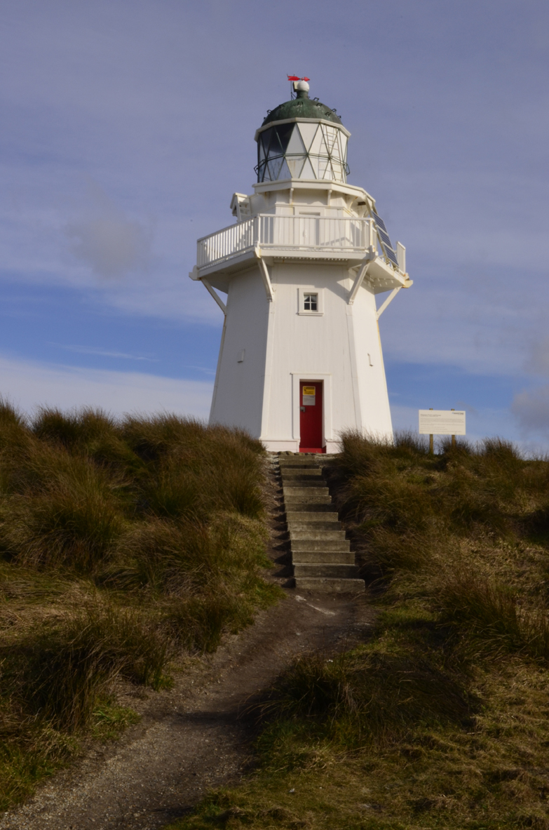
Just offshore are "The Nuggets", which are several jagged stacks of rock, a bit like the Needles at the Isle of Wight. These wave-eroded rocks can be seen from the viewing platform at the Nugget Point Lighthouse. A short cliff side track leads to the 1870 lighthouse on the tip of the headland, which still functions today.
The Nuggets can be seen just beyond the lighthouse
You get some amazing views of The Nuggets from the lighthouse
There are approx. 20 of these rocks, each with a Māori name
At the base of the cliffs we could just about see some New Zealand fur seals, but it was more the sound of their cries that let us know they were around! Nearby is a viewing hide at Roaring Bay (which is on the road to Nugget Point) so you can observe yellow-eyed penguins (Megadyptes antipodes) when they come ashore in the late afternoon, however, we were there at the wrong time of day.
Taking a scenic drive down to Cannibal Bay, we hoped to see some Hooker's sea lions (Phocarctos hookeri) as apparently this small and sheltered bay is a regular haul out site, as is Surat Bay. The drive to Cannibal Bay was a pretty pointless 8km stretch of gravel track that seemed to go on forever, a bit like the one at Nugget Point. Pretty much all the side roads off along the Catlins Coast are unsealed gravel roads. The beach was nice and secluded but that was about it - no sea lions, no birds, nothing, apart from a couple of New Zealand's 40 million sheep on the hills!
The Catlins is touted as one of the most remotest parts of New Zealand, and we learnt this the hard way when we tried to check into our hostel (Split Level Backpackers) in Owaka, where we found a note on the door asking us to call the owner because we had been double booked and had nowhere to stay... This was particularly frustrating as there's no mobile phone coverage down in this part of the country (unless you're on Vodaphone) as we found out, but that's another story.
After a lot of chasing our tails we eventually finished the day off at Surat Bay (which owes it's name to the ship Surat, wrecked on a sand bar, New Year's Day 1874) in an attempt to see some sea lions. Crossing a bridge over a small creek, we followed a poled route through some sand dunes but surprise, surprise the beach was deserted.
Reflections in the Catlins River on the way to Surat Bay
Shoe tree at Surat Bay
This is a really infuriating aspect of New Zealand, as what it offers in spectacular scenery, it seriously lacks in wildlife compared to somewhere like Australia. It's especially annoying when you go out of your way to visit the Catlins because the guide books hype up the area as a prominent place to see "nature at its best".
Sand dunes looking out towards False Island
The day wasn't a complete disaster though, as there was a beautiful sunset and we did spot a sea lion swimming in the bay and it even came over to the shallows to catch a breath. It was a really cool experience especially as it swum all the way over to us, but it was also a little intimidating as the sea lion was huge!
That tiny dot on the shore is the only proof that we saw a sea lion!
On our our second day, the weather changed from wonderful blue skies to overcast and threatening to rain. We were on a bit of a schedule as Lizzie had planned an itinery so that we would arrive in Curio Bay for low tide around 3.20pm, so we could see the site of the one of the world's most extensive Jurassic-era petrified forests. Heading off from Pounawea it was a short drive to Pūrākaunui Falls, a small three-tiered waterfall. The falls lie in a scenic reserve of silver beech trees and podocarp forests (trees that can be traced back to when New Zealand was part of the supercontinent, Gondwana).
The podocarp forest on the way to the falls
Pūrākaunui Falls cascade over 20m
Continuing along the Southern Scenic Route we stopped at the Table Hill Scenic Reserve, 5km south of the Pūrākaunui turn off to do a short 15-20 minute walk to Matai Falls and Horseshoe Falls. The trail itself was nice enough, as we were walking through native tree fuchsias (known as Kōtukutuku), which can be identified by their peeling pinkish bark when they're not in flower.
Me and Lizzie on the platform overlooking Matai Falls
Horseshoe Falls is further upstream and best seen when the river is high
Kōtukutuku is the largest fuchsia in the world
Fuchsia excorticata, is known as the NZ fuchsia
Moody skies over Tautuku Bay from the Florence Hill lookout
Further along the main road, a small side road runs 3km to McLean Falls, which is a picturesque 30 min return walk through a variety of forest and shrubs. It was easily the best bush walk we've done in the Catlins. It was lush, with moisture hanging in the air and green vegetation everywhere as there were mosses growing on the tree ferns and rimu. The falls themselves were nice but not as impressive as Pūrākaunui Falls but I think this was because we weren't able to get to the higher section of the falls as part of the track was closed due to rock fall.
Lizzie standing under an enormous Kōtukutuku fuchsia tree
Mosses thrives in the moist conditions of the temperate rainforests
The 22-metre McLean Falls are upstream on the Tautuku River
The lower tiers of McLean Falls
Once we reached Curio Bay we headed straight to the petrified fossil forest, which lies on a wave-cut platform. Over 160-180 million years ago when most of New Zealand lay beneath the sea, this area would have been a broad forest of tree ferns, cycads and cone-bearing trees that was part of Gondwana. Some of the fossil trees are related to the modern kauri and the Norfolk Island pine. It is believed that massive sheet floods of volcanic debris, perhaps triggered by heavy rain on a barren volcanic mountain, destroyed the forest. Today, the seashore is littered with fossilised tree stumps and logs that were submerged in blankets of volcanic mud and ash. After years of pounding by the sea, waves have worn away the soil to reveal the fossilised trees.
Unlike fossils, petrified wood is incredibly rare. Entire logs and tree stumps have been preserved in floodwater rich in silica, which impregnated the standing trees and turned them literally into stone within a matter of months before decay was able to set in - this process is known as "silicification".
The tree stumps are visible for four hours either side of low tide
One of the many rock pools on the tidal rock shelf
Logs were carried in the flood, which killed the rest of the forest
You can still see the grain texture of the petrified wood in the rock
Unfortunately, over time people have been slowly breaking off bits of the forest and removing rare fossils to keep them as souvenirs, however, this practice is discouraged as this is an internationally important site and the fossil forest needs to be preserved for others to enjoy in the future.
Following a tip from the local backpackers we were staying at, we were told that the petrified forest was a good place to see yellow-eyed penguins. Having tried on three separate occasions (once in Oamaru and twice on the Otago Peninsula) to see them, we were sceptical as to whether we would actually see the elusive little hōiho.
As we sat on on the rocks an hour before sunset, sure enough one penguin after the other came ashore as the late afternoon drew to a close. We were advised to stay at least 10m away from the penguins to avoid disturbing them as they make their way back to their nests in the flax bushes. Hōiho nest where they can find a cool, shady and moist place to avoid overheating.
I spy with my little eye, something beginning with P!
It's almost comical watching the penguins return back to their hides
"Hi honey, I'm home!"
We were really spoilt by one penguin who came towards where we were sitting quietly (we were virtually the only people there), it couldn't have been further than 10m away at it's closest point, stopping every now and again to stretch it's wings and have a good look around or give an exuberant trill - thus living up to it's name as the "noisy shouter". Yellow-eyed penguins are a taonga (treasured) species which recognises in law their importance to Ngāi Tahu - the Māori tribe of much of the South Island.
We must have seen around 10 penguins come ashore, but we could only stay for so long before we were being bitten to death by sandflies and we had to call it day. We were down there for a good hour or so and felt it was definitely a good time to quit while we were ahead!
Our very own "March of the Penguins"
For our final day in the Catlins we wanted to make our way round to Slope Point, which is supposed to be the most southerly point of the South Island (not mainland New Zealand though as you'd need to go to the third largest island, Stewart Island/ Rakiura for that). It was another epic and bumpy drive along 16km of unsealed roads just to reach the walking track to reach the rugged area. Apart from a sign pointing the distances to the Equator and the South Pole, there isn't much to see here aside from some farm land and the view across the Foveaux Strait (Te Ara a Kewa). It really wasn't anything nothing special, except for being able to faintly see Stewart Island, which is a shame as its complete contrast to when we went to Cape Rēinga. The only real significance of Slope Point for us is that this is the furthest from home we've ever been at 11,860 miles (19,085 km)!
Another obligatory photograph by the signpost!
If you look hard enough you might spot Stewart Island
Windswept macrocarpa trees at Slope Point
The last stop on our journey through the Catlins was Waipapā Point. This was the site of New Zealand's worst civilian shipwreck, when on 29th April 1881 the steamship, SS Tararua struck the treacherous Ōtara Reef - as a result 131 lives were lost. The lighthouse that now stands on the point was erected three years after the shipwreck and it was as we were walking through the scenic reserve that we finally stumbled upon some Hooker's sea lions!
Waipapā Point guards the eastern entrance of the Foveaux Strait
The tower is clad in kauri and tōtara wood
Waipapā Point was one of the last Foveaux Strait lighthouses to be erecetd, although it became one of the first to be connected to the national electricity grid.
The New Zealand/ Hooker's sea lion (Pakake) is possibly the rarest of the world's five species of sea lion and is only found in New Zealand. They once lived all around the coast but today they mostly live around the sub-Antartic Auckland Islands as well as breeding in the Otago Peninsula, along the Catlins and around Stewart Island after they were nearly hunted to extinction over 200 years ago.
Sea lions are a lot larger than fur seals and have distinctive blunt noses
Sea lions prefer to laze about on sandy beaches unlike fur seals.
Sea lions are able to move faster on the sand than humans can, so you have to be careful around them as the biggest adult males can weigh up to 400kg and are not afraid of people. Finally seeing the wildlife that we tried to see on so many different occasions round the South Island was a fitting way to finish our time in the Catlins!
A couple of boisterous sea lion pups play fighting
When we visited Dunedin five years ago we arranged to do a wildlife tour on the Otago Peninsula with the renowned Elm Wildlife Tours. This time round we wanted to explore the peninsula and see some wildlife on our own, as we have a car to take us to places off the beaten track.
Dunedin is nestled at the head of Otago Harbour and sits on the doorstep of the peninsula. The harbour was formed around 10 million years ago by volcanic eruptions and is virtually surrounded by rugged hills. The Otago Peninsula separates the harbour from the Pacific Ocean and has long been acclaimed for its beauty, abundant marine wildlife and eco-tourism.
Although the Otago Peninsula is a short drive from Dunedin, we filled up our car with petrol before venturing on to the peninsula as there is nowhere else to fill up whilst you're on there. There are two main roads round the headland, Highcliff Road and Portbello Road each taking very different, but equally spectacular routes, offering sweeping views of the harbour on one side and the Pacific Ocean on the other.
Driving up Highcliff Road we decided to head over to Sandfly Bay on the eastern side of the peninsula to see a colony of yellow-eyed penguins (Megadyptes antipodes) that are resident in the area and which is also a popular site for spotting Hooker's sea lions (Phocarctos hookeri). Having already seen Little Blue Penguins (kororā) at the Blue Penguin Colony in our fleeting visit to Oamaru (and we also saw them at Phillip Island in Australia), we were unlucky not to see yellow-eyed penguins at the Bushy Beach colony (in the Waitaki District) - but I guess they're not known as New Zealand's rarest penguin for nothing!
Looking across Sandfly Bay and Lion Rock from Seal Point Road
Somewhere in these sand dunes live some yellow-eyed penguins
One of the many beautifully sculpted sand dunes
Yellow-eyed penguins are unique to New Zealand and are the largest species of penguin living in a temperate region. They might also be the rarest penguin species in the world with a population of between 6,000-7,000 individuals. Known as hōiho (the Māori word for "noise shouter") they're easily distinguished from other penguins by their yellow iris and yellow band of feathers across the back of their heads. Hōiho are only found on the south-east coast of the South Island in mainland New Zealand and on the islands off Stewart Island, Stewart Island itself, the Auckland Islands and Campbell Island. Yellow-eyed penguins are considered such a national treasure (taonga) that they're on the reverse side of the $5 note, with Sir Edmund Hillary - the first person to climb Mt. Everest with Tenzing Norgay - on the other side.
Reverse-side of a $5 note depicting a scene on Campbell Island with a hōiho
Front-side of $5 note with Sir Edmund Hillary and Aoraki/ Mt Cook
Heading down a relatively steep sand dune to reach the beach, we then walked a kilometre along the beach to the southern end where a marked track lead us up to a hide to view the penguins. When we reached the hide there was a notice saying that the best time to see penguins is two hours before dusk and unfortunately we were there in the middle of the day! Although the bay itself was very picturesque and dramatic, it was pretty pointless going down to the beach for spotting wildlife, as all we saw was one sleeping sea lion and a couple of variable oystercatchers.
A variable oystercatcher and Lion Rock in the background
And I thought Baldwin St was bad! The climb back up the dune was a bit epic
In conclusion, Sandfly Bay is possibly is best saved as the last stop on your way out of the peninsula. The only saving grace was that we weren't being bitten by the blood sucking insects that the bay is thought to be named after - in fact the name actually refers to the sand flying off the top of the giant dunes.
Next stop along the peninsula was Taiaroa Head (originally known as Pukekura) at the very tip of the headland to see the Royal Albatross Centre via the small village of Portobello. Driving out towards the north eastern point of the peninsula, we straddled alongside the scenic Portobello Bay where the tide had gone out a long way leaving behind mudflats.
The Royal Albatross Centre is the only mainland breeding colony in the world for the Northern Royal Albatross (Diomedea sanfordi). Along with the Wandering Albatross, the Royal Albatross are the largest seabirds in the world, spending at least 85% of their lives at sea. Inside there are some interesting displays on the Royal Albatross as well as other local wildlife and history, however, a 45 minute guided tour of the centre costs $40 each so we decided to give it a skip. Despite opting to save our pennies, we were a little bit fortunate to see a couple of albatrosses majestically soaring on the thermals from the café area whilst we were having a cup of tea.
An "albatross" we spotted nestled in the bushes!
The centre is also the starting point for tours round the historic Fort Taiaroa, a warren of tunnels and gun emplacements originally built in 1886 to counter the potential threat of a Tsarist Russian invasion in the late 1880s and later used for training and defence during the First World War and World War II. However, the main attraction is the Armstrong 6-inch disappearing gun, which is actually a massive canon operated by hydraulics. Apparently, it is the only one still in working condition remaining in the world!
Before Taiaroa Head was established as a Fort over 100 years ago, it was originally a significant fortified Māori pā site for the Kāi Tahu tribe when it was first built around 1650.
View to Aramoana Spit and Portobello Bay from Taiaroa Head
Next we headed over to Allans Beach via some some narrow unsealed roads taking us right down to the water's edge at Papanui and Hoopers Inlets. I wouldn't have liked to have seen these roads once they flooded as it didn't look like it would take much to do so!
Taking a short 5 minute walk down to the beach, there wasn't much in the way of wildlife around, especially as it was a dog-friendly beach, which I thought was a bit strange considering there were plenty of signs warning you to watch out for sea lions and making sure that you keep your distance. The weather also took a turn for the worse with the skies clouding over and threatening to rain so we decided to give up for the day.
Wharekakahu is a steep-sided stack that you see from Allans Beach
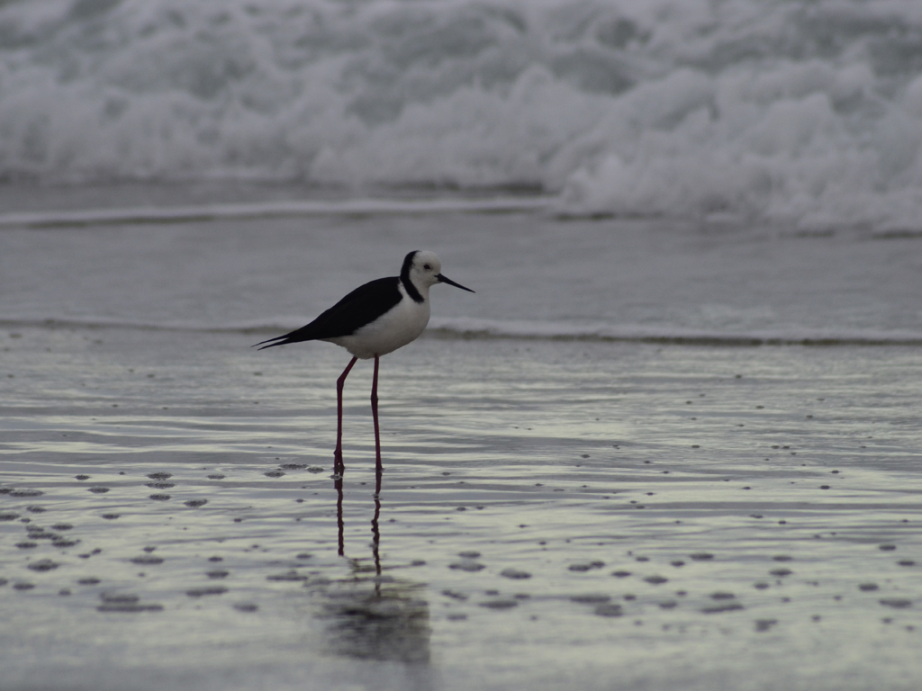
A white-headed stilt (Himantopus leucocephalus) on the beach
Overall, it was a bit of disappointing day, which is a shame as the Otago Peninsula is a beautiful area, but we had expectations to see some penguins and sea lions as we had an unforgettable wildlife encounter when we were here last. I think the moral of the story is that it might be better to go on an organised wildlife tour as they know the best viewing spots (which are usually on private land) so you can see fur seals, sea lions and penguins in the best way possible to avoid disturbing the wildlife.
*** Following our underwhelming day at the peninsula, we had another crack at spotting some yellow-eyed penguins back at Sandfly Bay on a different day via a scenic walk at the Sandymount track to Lovers Leap and The Chasm. From here it's possible to walk back to Sandfly Bay in about 45 minutes.
A panorama of the Mt Charles and Hoopers Inlet from Sandymount Road- click here to view in hi-res
The track gives spectacular views of the Otago Peninsula's coastline and cliff tops, and leads to a couple of unfenced sheer cliff drops of at least 200m down to the sea - Lovers Leap in particular is part of a collapsed sea cave. Standing on the view platform next to The Chasm renewed my healthy respect for heights as I got a sense of vertigo having a peak over the edge...
The sign isn't kidding about an unprotected edge!
The Chasm is so steep that I couldn't get a shot of the bottom!
Lovers Leap and the cliffs at Sandymount are remnants of a volcano
Despite timing our return to Sandfly Bay an hour and half before dusk we still had no joy with seeing the penguins returning from their day at sea. It would be worth the Department of Conservation putting a proviso on their notice boards that you can only see these animals at certain times of the year, but generally I got the impression that spotting yellow-eyed penguins was a year-round activity.***