


 |
| On the left iconic Mitre Peak rising 1,692m from the fiord at Milford Sound |
Starting our Doubtful Sound adventure, we needed to drive to the small township of Manapouri (population of 210!) in the southwest corner of the South West. Driving from Queenstown down to Manapouri via the Southern Scenic route, it roughly took us 2 hours (172km) following State Highway 6 and then picking up State Highway 94 at Mossburn. Lake Manapouri resides within Fiordland National Park and the Te Wāhipounamu (the place of greenstone) World Heritage area. As mentioned previously, Manapouri is largely used as a starting point for cruises to Doubtful Sound, and getting to the fiord is an an adventure in itself, as it can only be accessed by crossing the lake as part a tour, following by a coach ride over the Wilmot Pass through some dense cool temperate rainforest to Deep Cove.
Lake Manapouri is the fifth largest lake and second deepest in NZ with four major arms; North, South, West and Hope as well as small indentations at Calm Bay and Shallow Bay. The lake has 32 islands, of which 22 are wooded. The largest island is Pomana Island, which lies close to the centre of the lake. Other notable islands include Holmwood, Rona and Mahara Islands. The Waiau River is both a natural inflow and outlet for the lake, flowing northeast of the lake from Lake Te Anau. The lake's catchment is also served by the slopes of the Kepler Mountains, Turret Range and Hunter Mountains that surround all but the eastern shore of the lake.
According to Māori legend, Lake Manapouri was formed from the tears of two sisters, Motorau and Korowae, daughters of an old chief in the region. The name Manapouri is Māori for "sorrowful heart", although, due to a cartography error the original Lake Manapouri was North Mavora Lake, which lies between Lake Te Anau and Wakatipu. The lake's original name is believed to have been Roto-ua (Rainy Lake). Local Māori also called Lake Manapouri, Moturua which means "many islands".
It wasn't the best start to the trip as we arrived to a drenched Manapouri (the weather forecast for Fiordland for the weekend was for 100mm of rain) and it was already getting dark at 7.30pm as there were many heavy clouds with the rain thrashing outside.When we woke the next morning, we were surprised to discover it had been actually snowing over night, although the weather report was for snow down to levels of 400m.
 |
| Kepler Mountains to the northwest of the lake |
 |
| Clouds looming over the Hunter Mountains |
 |
| It was a wonderful sight seeing the mountains after the storm |
In our usual style, we arrived fashionably late for check-in at Real Journeys office by the entrance to the Wairau River, although it was still another 15 mins before we would actually board our vessel (the MV Titroa) to take us across the lake.
The initial cruise across Lake Manapouri took us roughly 45 minutes, passing many of the bush clad islands the lake is famous for, however, it was raining/sleeting quite steadily and the visibility was pretty poor so I was a little concerned how much we would be able see at Doubtful Sound. I was particularly keen for reasonable weather as I was testing out the optical quality of a Sigma 18-200mm f/3.5-6.3 DC telephoto zoom lens that I borrowed from work!
 |
| Lake Manapouri isn't know as Moturau (many islands) for nothing |
 |
| Passing Cone Peak (1,495m) and the South Arm of the Lake |
 |
| Beanies, scarves and waterproof jackets are the order of the day |

 |
| Evidence of landslides on the side of the mountains |
 |
| Titiroa is also a prominent mountain in the Te Anau Basin area |
 |
| The mysterious but stunning falls on the North Arm of the lake |
Arriving at the tip of the West Arm of the lake we disembarked from our the vessel by the Manapouri Power Station. From here we would take the next form of transport, a coach over the Wilmot Pass to take us into Deep Cove at Doubtful Sound.
The 671m high pass was built in the mid 1960s to provide heavy equipment access for the construction of the power station. According to the coach driver, the Wilmot Pass cost $2 for every cm layed, by my reckoning the 22km road must have cost $440,000 to build, making it one of the most expensive roads built in New Zealand at the time. Floods, snow, mud and landslides lengthened the initial project from 12 months to 2 years!
 |
| It was a beautiful sight seeing all the snow on the Wilmot Pass |
 |
| Silver beech (tawhai) trees dominate the forest on the pass |
 |
| Not the sign you want to see coming down the other side |
Fiordland National Park is the largest of New Zealand's national parks - an area roughly the size of Wales at 1.25 million hectares or 3 million acres, and Doubtful Sound lies in the heart this designated World Heritage Listed area - Te Wāhipounamu. Fiordland is considered New Zealand's rawest wilderness area with jagged forested mountains, intersected by numerous deeply recessed fiords in some of the most inaccessible parts of the country.
It also happens to be one of the wettest regions in New Zealand. Moist westerly airstreams fan across the Southern Ocean and South Tasman Sea, before crashing into the high landmass. The average rainfall increases the further West you move into Fiordland, for example:
- At Manapouri the average rainfall is 1,200mm rain a year
- At the West Arm of Lake Manapouri the average rainfall is 3,500mm rain a year
- At Deep Cove the average rainfall is 5,300mm rain a year or the equivalent of 25ft!
It's not all bad news though, as the area has numerous amazing waterfalls and forests to enjoy, thanks to the 180 days worth of rain in Fiordland each year.
Arriving in Deep Cove for the start of our cruise, our boat for the Doubtful Sound was the Patea Explorer, an impressive catamaran with three decks and two covered areas at the stern. As we headed slowly towards the mouth of the Tasman Sea, the cruise was estimated to take 3 hours to get around the fiord, as Doubtful Sound is three times longer and ten times larger than it's better known cousin Milford Sound. However, it's not the largest of Fiordland National Park's 14 fiords - that title belongs to Dusky Sound.
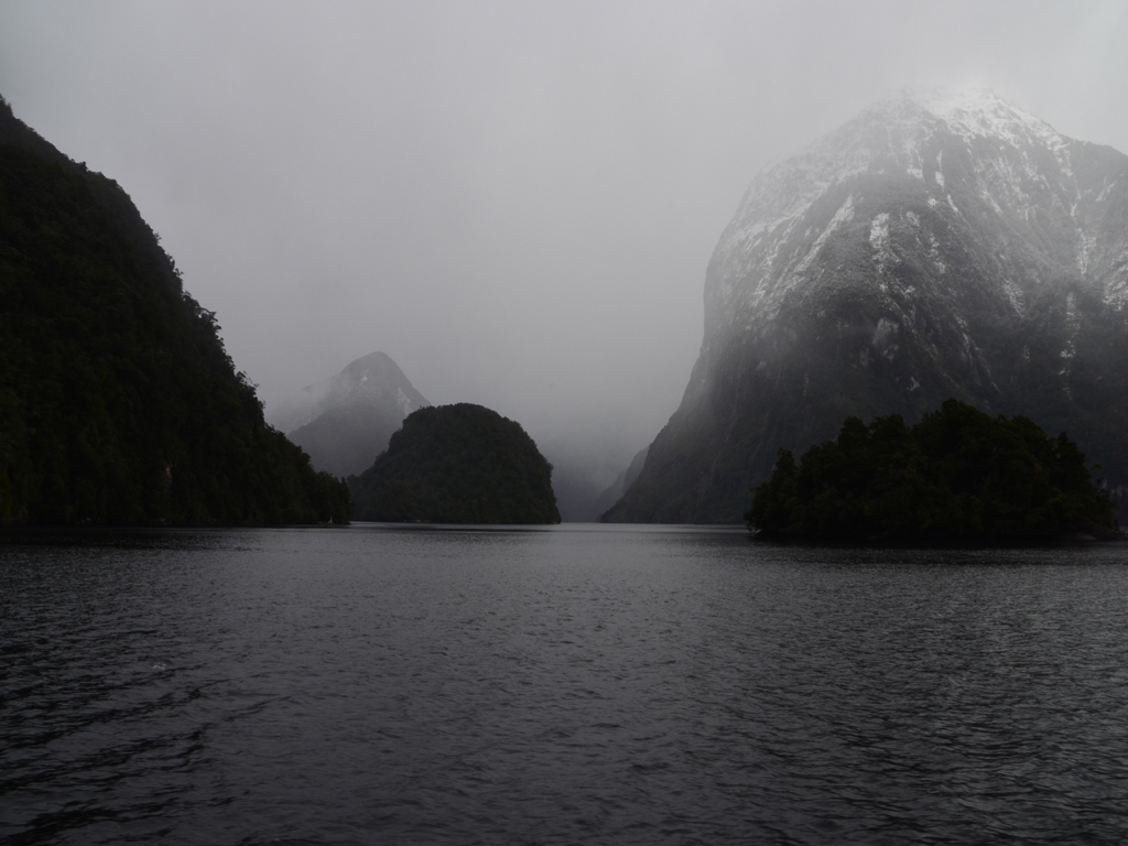 |
| The fiord looked moody and dramatic in the heavy mist |
 |
| Passing the end of Elizabeth Island (Taipari Roa) in the foreground |
 |
| Looking up the Crooked Arm at Kellard Point |
According to Māori legend, Doubtful Sound and the other fiords were created by a godly figure (Atua). Tu-Te-Raki-Whanoa, the creator of the fiords wanted to create long winding inlets that would serve as refuges from the stormy seas. When Tu crafted Doubtful Sound (Patea) he was assisted by four young sea gods named Taipari, who created the arms - First Arm or Taipari-poto (short), Crooked Arm or Taipari-nui (big), Hall Arm or Taipari-row (long) and Deep Cove or Taipari-tiki (little).
 |
| It was absolutely freezing on the top deck if you can't tell. |
New Zealand is fabled for having unpredictable weather and four seasons in one day, and we literally had one of those days! We had rain, snow, sleet, blustery breezes, blue skies and the sun all rolled into one - it certainly made it challenging to get photos without getting droplets all over the Sigma 18-200mm f/3.5-6.3 DC camera lens especially as the autofocus feature wasn't compatible with my Nikon D5100. But a plus side of the stormy weather we're experiencing was that there were lots of small waterfalls cascading into the fiord due to all the rain water running down the sides of the mountains. Not to mention the snow topping all the peaks, making it an even more beautiful sight that usual.


Once we reached the entrance of Doubtful Sound we couldn't venture any further as the swells were quite rough on the Tasman Sea.
 |
| The Te Awaatu Channel between Bauza and Secretary Islands |
The first European to discover the fiord was Captain James Cook during his search for the "Great Southern Continent". Doubtful Sound was originally called Doubtful Harbour, as when Captain Cook observed the fiord from the coast in 1770, he was "doubtful" whether the winds would be sufficient to manoeuvre the Endeavour back out to sea from the fiord. It was reported that the scientists on board wanted to land but Cook wouldn't take the risk. Twenty-three years later the outer reaches of the fiord were explored by a Spanish expedition led by the Italian explorer, Alessandro Malaspina.
In terms of wildlife spotting, were a little unlucky not to see Fiordland crested penguins (tawaki) as their breeding season offers the best viewing opportunities. We cruised passed Rolla and Shelter Islands but they were nowhere to be seen...
 |
| This is the closest we got to seeing a Fiordland crested penguin |
However, we did see some bottlenose dolphins (which are the most southernmost in the world) and a lonesome New Zealand fur seal relaxing on the rocks by Marcaciones Point where a plaque dedicated to the Spanish explorers commemorates Malaspina's expedition. No other part of New Zealand has a such collection of Spanish place names as Doubtful Sound!
 |
| A lonesome fur seal at Marcaciones Point on Bauza Island |
 |
| Sadly no penguins were hiding in the Shelter Islands to the left |
 |
| This hut in Blanket Bay is the only building in Doubtful Sound |
As we turned back from Te Awaatu Channel, we took a detour down the atmospheric Crooked Arm, which is actually longer than Milford Sound itself!


What was really impressive about some of the mountains in the glacial valley was that the forests on the mountainsides had been able to develop right down to the water's edge, even in the absence of deep soil development. Underneath the interlocking root systems of trees lies smooth, solid rock hence why the tree line lies so close to the water's edge. Tree avalanches are common in the area, usually triggered by high rainfall or heavy snow as evidenced by the "scars" or bare patches of rock where the fiord has claimed the trees. An earthquake measuring 7.2 on the Ricther scale struck Doubtful Sound back in 2003 and caused approx. 260 tree avalanches, however, a much stronger earthquake was recorded in 2009, which measured 7.8!
Before we finished our cruise, we had one last opportunity to get an up close and personal view of the stunning Lady Alice Falls, Fiordland's tallest waterfall!


As we pulled back into the wharf, our coaches were ready to take us back up the Wilmot Pass but not before we stopped off at the top the pass to get a view overlooking Deep Cove and to more importantly, to have a play in the snow!


 |
| Although the visibility was poor, it's still a great view into Deep Cove |
 |
| Lizzie getting carried away in the snow! |
Before we made our return journey across Lake Manapouri, we had one last treat in store - a journey into the heart of the granite mountains to the underground power station! Lake Manapouri is the site of the largest hydroelectric power station in New Zealand with its generating units housed in a cavern excavated from the rock 200m below the lake. Having already had the pleasure of doing a tour of the Dinorwig Power Station in Wales more than once, I was ready for another marvel of engineering - can you detect the hint of sarcasm!?
To get to the underground machine hall of the power station, our coach drove through a spiral tunnel carved 2km into the mountain. When power station was first constructed trucks had to reverse down the tunnel when delivering machine parts (as there's no turning room at the end), which sometimes took up to 12 hours! The power station was originally built to supply the power requirement of Comalco Aluminium Smelter, 171km away at Bluff. However, in 1963, the New Zealand Government had to take over the construction costs of building of the power station as Comalco could only finance the smelter.
 |
| The Manapouri power station machine hall |

The station utilises the 230m drop between the West Arm of Lake Manapouri and Deep Cove 10km away to generate electricity. Building the power station and constructing the road over the Wilmot Pass was dangerous work, and it tragically claimed the lives of 16 men whose names are on a memorial plaque on the rock that forms the power station they helped create. I guess in a funny way if the campaign to prevent the construction of the power station was successful then Wilmot Pass possibly wouldn't have existed and Doubtful Sound would be even more inaccessible today than it already is for tourists.
Our verdict on the trip was despite the slight worry about the weather, having all the overnight snow made it a better experience than when we went to Milford Sound five years ago. As to whether it would be better than Milford overall on a different day, the jury is open...The Doubtful Sound experience is much more magnificent in terms of a cross section of wildernesses - going from a lake to an alpine pass and a vast fiord. However, you don't get the imposing Mitre Peak or the scenic journey up the Milford Road...