This is my second attempt at writing this post which possibly took me close to 20 hours to perfect and has now been lost in the ether of the internet ("damn you Google and your shoddy blog service"), so apologies if it's not as good as the original but as you can imagine I was quite distressed at the time but here goes...
Having already been to
Lake Tekapo during winter we had heard and read that the lakeside is covered in a beautiful carpet of Russell lupins (
Lupinus polyphyllus) during the spring each year from mid-November to December. You don't necessarily need to go Lake Tekapo to go see them as there's blankets of them in and around Queenstown and it wouldn't surprise me if it was the same at Wanaka as well but where's the fun in that?
As pretty as Russell Lupins are, they are actually considered an aggressive weed as they have invaded the braided riverbeds in Canterbury, which is having a major impact these ecosystems. Russell lupins change these unstable braided river environments, which home to unique native bird and native plant species, by forming dense stands on bare gravel areas.
Russell Lupins were thought to be introduced by Connie Scott of the nearby high country Godley Peaks Station, when she scattered thousands of seeds along the bare highway from Burkes Pass to Tekapo. Lupins in the Arthurs Pass area had spread from the home gardens of railway workers. These tall spikes of colour now grow in abundance along many roadsides, open areas around the Lake Tekapo, and throughout the scenic Mackenzie country. It is rumoured that tour coach drivers were also responsible for spreading lupins around the countryside to improve the areas that tourists thought were drab - who were these people? As if the natural beauty of New Zealand needs improving!
So as part of another weekend road trip from Queenstown, we wanted to see these spectacular Mackenzie Country blooms as well as providing us with another excuse to check out the rest of what
Aoraki/ Mt Cook National Park has to offer. Driving past Cromwell and the man-made Lake Dunstan, through the 45
th Parallel (or the circle of lattitude 45 degrees south of the equator - half way between the equator and the South Pole) we picked up State Highway 8, which is the start of the Lindis Pass. This makes the 45
th Parallel the most southerly producing wine region in the world!
The Lindis Pass is the highest point on the South Island's state highway network, and the second highest point on the New Zealand State Highway network, after the Desert Road (SH 1) on the North Island in Tongariro National Park. The actual pass crosses a saddle between the valleys of the Lindis and Ahuriri Rivers at an altitude of 971m above sea level. The stunning scenery driving through the Lindis Pass and was a little reminiscent of the landscapes from Lord of the Rings!
 |
| The sweeping mountains of the Lindis Valley |
 |
| Blooms of lupins can be found throughout the Lindis Pass |
It was really nice as we drove along the Ahuriri River with the lupins on the banks of the river and the Southern Alps starting to appear on the horizon. We then passed through Omarama, a small township in the centre of the South Island, at the other end of the Lindis Pass but there wasn't much to see! Crossing the boundary between Otago and Canterbury we passed through Twizel before reaching the corner of Lake Pukaki for the turning off to Aoraki/ Mt Cook National Park. It was here that we stopped for a break as we had been driving for approx two and half hours from Queenstown. We got a magnificent view of Aoraki/ Mt Cook across the stunning turquoise lake unlike last time where there was too much low lying cloud.
 |
| Ben Ohau range on the left and the Mt Cook Range |
 |
| The same view from our last visit |
 |
| Aoraki/ Mt Cook 70km away from across Lake Pukaki |
Aoraki/ Mt Cook (3,764m) looked really imposing and we were able to see it pretty almost all the way to Lake Tekapo before we eventually lost sight of it on the horizon. Once we arrived at Lake Tekapo, we quickly checked into our hostel and headed straight down to the lakeside to see the Church of the Good Shepherd as we were cutting it fine for sunset.
 |
| The Church of the Good Shepherd just before sunset |
 |
| Panoramic view of Mt John (1,031m) and Lake Tekapo shoreline at sunset - click here to view in hi-res |
 |
| Someone is trying to hide in the lupins! |
 |
| Lizzie among sitting pretty amongst the lupins |
 |
| The Godley Valley at the head of Lake Tekapo |
 |
| Panorama of Lake Tekapo at sunset - click here to view in hi-res |
When we got down to the lake there was a wonderful smell of lupins in the air but also a small army of photographers spoiling the ambiance. Maybe someone should at least write some sort of photographer's "Code of Conduct" so you don't cross into anyone else's shots when you can see someone is taking a picture! I guess it's naïve of me to think that such a remarkable and sparsely populated area would be tranquil and serene but I guess it is a photographer's dream (partly why we went there in the first place) and it's this easily accessible natural beauty which draws a lot of tourists to the area. It just shatters the illusion when you see these beautiful photographs in the guidebooks...
 |
| A slightly exaggerated example of the ugly truth behind beautiful pictures! |
The following day we managed to drag ourselves out of bed at 5.20am for sunrise - a major achievement in itself! But it was worth it for the uninterrupted views of the mountains and lupins by the Church of the Good Shepherd.
 |
| We really couldn't have asked for a better start to the day |
 |
| The sunrise was truly stunning over Mt Hay (1,174m) |
 |
| A panoramic HDR view of Lake Tekapo at sunrise- click here to view in hi-res |
 |
| The peaks of Gammack Range towards Mt Cook National Park |
 |
| Mt Erebus (2,309m) is a prominent peak in the Sibbald Range |
 |
| Mistake Peak (1,921m) with the Sibbald Range on the right |
 |
| A couple of sleepy tourists posing by the Church of the Good Shepherd |
 |
| Panoramic view of Lake Tekapo and the Godley Valley at sunrise - click here to view in hi-res |
 |
| The sheepdog memorial overlooking Mt John |
Driving round to the hot springs there was a huge carpet of lupins by the edge of the shore by the base of Mt John along Lakeside Drive. If you took a moment to listen you could hear the hum of hundreds of bees busy collecting pollen. The lupin flowers come in a variety of colours including blue, purple, yellow, pink and white or a mixture of two colours.
 |
| A panoramic view of the Lake Tekapo lupins from the base of Mt John - click here to view in hi-res |

 |
| A honey bee (Apis Mellifera) loaded with pollen on it's legs |
 |
| Russell Lupins towering over California Poppies which are also considered invasive |
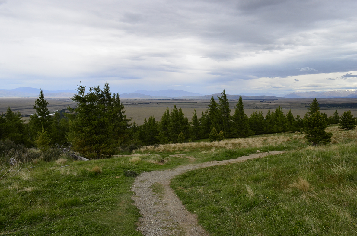
The main reason why we came to Mt John was to rewalk the
Summit Circuit Track to see what it would like without all the snow. It was certainly a lot quicker to reach the top of this roche moutonée than last time as it wasn't as slippery with all the snow and ice, however, it was a bit of an overcast/ humid day so not as nice before. One thing that I forgot was how calm and serene it was at the summit of Mt John.
 |
| Before... |
 |
| ...after |
 |
| Winter... |
 |
| ...spring |
 |
| The blanket of lupins down where we started off at Lakeside Drive |
 |
| An observation point above the larches in winter |
 |
| The same view in spring |
 |
| On the summit of Mt John |
 |
| Looking back down on the village across the Mackenzie Basin |
After taking a short break at the summit, we waited to see if the skies would blow over but instead we were just getting blow around so decided to go back down after a cheeky hot chocolate at the Astro Café before heading back down the way we came.
 |
| The telescopes at Mt John University Observatory |
Comparing and contrasting the two occasions that we've been to Lake Tekapo, we felt that Tekapo on a crisp winter's day just edges the lupins during the spring but we would highly recommend checking out this fantastic on either occasion as part of a day-trip.
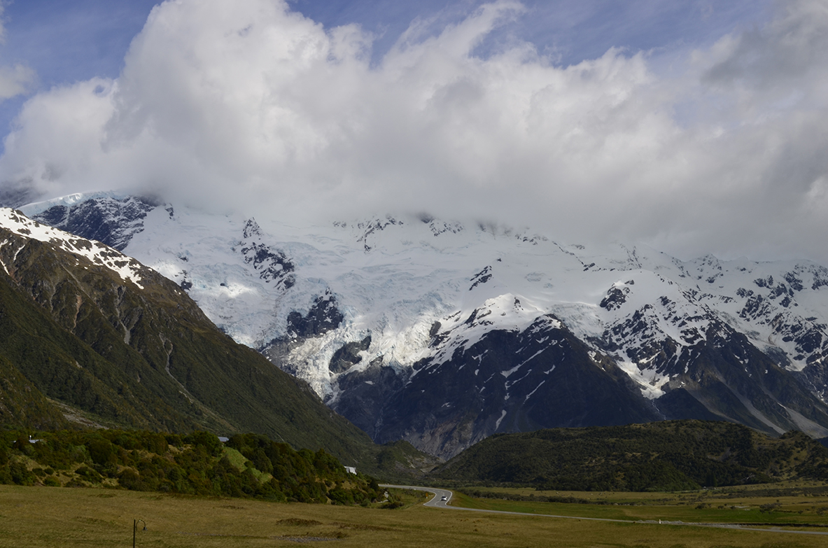
Moving on from the Mackenzie Basin we drove back to Lake Pukaki to the southwest corner, where you pickup the Mt Cook Road (also known as State Highway 80) for our return visit to the mountain known as "
Cloud Piercer". Driving along the 47km length of Lake Pukaki, the lake was a vibrant shade of turquoise despite the weather being quite grey and cloudy. As we passed through Glentanner, there were some seriously strong cross winds blowing the car all over the place as the storm clouds we descending over Aoraki/ Mt Cook National Park!
Bad weather put an end to our day just as we arrived at Mt Cook Village so we checked out the fantastic Department of Conservation Visitor Centre for more information in preparation for the following day and to check the weather report to if it would be possible do the Sealy Tarns track. In a bit of anticlimax to the day, we retreated to our modest accommodation, the very dated Mt Cook Backpacker Lodge. This former hotel is one of only a few accommodation options in Mt Cook Village and was on the steep end of our budget but at least we got a room with a balcony facing the Hooker Valley.
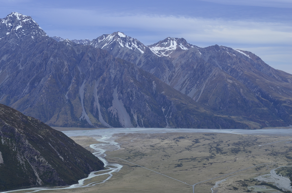
In a last minute bid to rescue the day, we noticed that the Tasman Valley was looking clearer than the Hooker Valley where we couldn't even see Aoraki/ Mt Cook, so just before sunset we drove down Tasman Valley Road, an 8km stretched of unsealed road (2km of which you're not supposed to stop on due to rockfall!), which has a bridge crossing over the Hooker River. For a fleeting moment there were blue skies over the eastern side of the Mt Cook Range. The hope was that we would be able to see the longest (at 27km) and largest glacier in New Zealand - the Tasman Glacier.
When we arrived at the car park the blue skies had gone but we just had to make the most of the weather we had. Walking up to the Tasmin Glacier lookout it was a 15 minute uphill walk. En route we passed the Blue Lakes which were more like green puddles - it's safe to say they weren't that impressive.
 |
| View down the Tasman Valley looking back towards Lake Pukaki - click here to view in hi-res |
 |
| The Blue Lakes with Mt Wakefield (2,058m) and Mt Kinsey (2,083m) |
Once we reached the lookout, after climbing some scree the clouds were descending from the Tasman Valley. It was difficult to tell what was the glacier as the ice was so dirty - it just looked like part of the morraine. At present, the glacier is retreating at a rate of 180m/ year so given 20 years the Tasman Glacier will have completely disappeared and we might already be past the point of no return to reverse this, which is a depressing thought.
 |
| Standing with the terminal face of the glacier and Novara Peak (2,298m) |
 |
| Panoramic view of the Tasman Glacier and lake with The Armchair (2,072m) - click here to view in hi-res |
Before long the rain finally arrived and it was time for us to head back to the hostel and hope tomorrow would be a better day...
Waking up at 5am in the vague hope of a sunrise there were some really winds blowing down the Hooker Valley with still quite a lot of clouds covering the mountains. At around 9am it was looking a lot better, although there a lot of cloud cover the top of Mt Sefton (3,151m) so we decided to head over to the Department of Conservation to find out more about the Sealy Tarns and
Mueller Hut trails.
 |
| A promising view from our balcony with blue sky over the Sealy Range! |
 |
| The ridge of Mt Wakefield (2,058m) |
The staff member we spoke to said to us that the Sealy Tarns Track was fine to walk despite it being windy, and that it is possible to get to the Mueller Hut but we would reach the snow line on the mountain, which was 2-3m deep in places and there were snow drifts of about 6m at the hut! With this information in mind we drove to to the White Horse campsite to start our walk as this cuts off 30 mins if you started at the village.
 |
| Lizzie pointing at the hidden peaks of Mt Sefton and The Footstall (2,764m) |
 |
| Avalanches are a considerable danger during spring when snow melts! |
Walking along a gravel path towards Kea Point we then picked up the Sealy Tarns Track as we were climbing steps from here onwards - it got steep and we had to stop quite regularly as it was quite windy. We had read in the memorial books at the Department of Conservation Visitor Centre that someone had died back in
2008 on the Sealy Tarns Track after straying off the route so we wanted to be a bit careful.
 |
| Taking in the impressive view as we head up the Sealy Tarns Track |
 |
| The imposing Aoraki/Mt Cook in all her glory |
 |
| The start of the Mt Cook Range at the edge of the Mueller Glacier lake |
 |
| Lizzie posing with famed Mt Cook lily, Ranunculus lyallii |
The higher we went the better the views unfolded: first of all the Mueller Lake, then the Hooker Glacier behind the moraine and eventually all the way down the Hooker Valley from the glacier down to the lake and then the river. What makes Aoraki/ Mt Cook National Parkso impressive is that it contains more than 140 peaks standing over 2,000m.
 |
| Panoramic view of the Mt Cook Range from the Sealy Tarns Track- click here to view in hi-res |
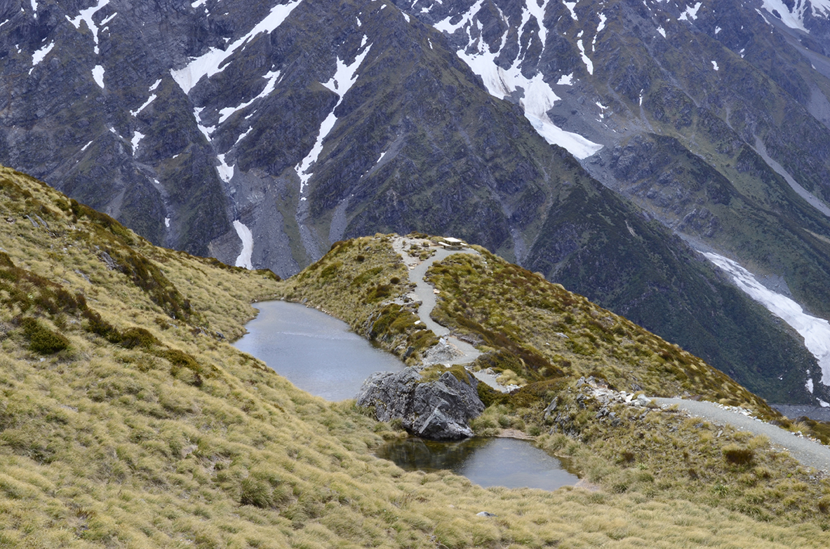
In all it took us about 1 hour 30 mins to reach the tarn, zip-zagging over 1,810 steps made from 5km of timber and 1km with a few stops along the way and small stream crossing.
 |
| No time for we feet we've got a tarn to reach! |
 |
| A tarn is a small alpine pond. |
 |
| Another tarn looking back towards the Burnett Mountains |
By the time we got up to 1,300m it had clouded over a lot and the face of Aoraki/ Mt Cook was cloaked behind the clouds but we were able to admire the mighty ice shelves directly opposite us on Mt Sefton.
 |
| Spectacular glaciers and ice shelves |
 |
| A breathtaking view of The Footstall and Cadogan Peak |
From here we had two options:
- Wait for someone to lead the way up the Mueller Hut Route.
- Turn back around and go back down the way we came.
Lucky for us there were quite a few people continuing up to the Muller Hut. At this point we were now following poles and orange markers up a scree route for 500m. This was a little more challenging than anything we've done before as it required having sure footing and climbing over loose rocks.
 |
| Lizzie at the first pole marker of the Mueller Hut Route |
Once we reached the snow line it was quite exposed and steep, there were six other groups who all had a go and wading through the snow
 |
| Where the alpine tussock and rocks end and the snow begins! |
 |
| I love snowy mountains, I really can't think of anywhere I'd rather be. |
The furthest one group got was six poles (possibly 600m) beyond where we stopped but they eventually gave up as well, as it was so steep and one person in their party was wading in deep snow wearing jeans and trainers! Not exactly the most clever thing to be wearing on a mountain!
 |
| This is the further anyone got all day on the Muller Hut Route |
In a lot of the ways the DOC are an excellent organisation but they should also be known as the Department of Crap as they could have warned us how steep the gradient was for the final section of walk was to the summit, it was impossible to get very far without the aid of walking poles.
 |
| The Hooker River carving pattern as it meets the Tasman River |
 |
| Panorama of the Hooker Valley from the Mueller Hut Route- click here to view in hi-res |
Coming back down on the loose scree was actually more difficult than on the way up and I noticed that there was a stream to cross which I didn't remember on the way up. As we made our way down from Sealy Tarns the stream under the waterfall we crossed had got a lot deeper, compared to when we crossed it earlier and in the DOC leaflet ("
Walks in Aoraki/ Mt Cook National Park") it mentioned that we should be prepared for "unexpected streams" crossings. Either way we were more prepared to get our feet wet than get too close to the edge of the track where the drop off was quite steep. This could have been due to the snow melting rapidly or even from all the rainfall the night before...
 |
| Sealy Tarn from our descent down the Mueller Hut Route |
 |
| The stream from earlier cutting across the track and over the edge! |
In all the walk to Sealy Tarns and partway along the Mueller Hut route took us 4 and ½ hours return although our legs felt like jelly by the end of it, coming back down all those steps! Getting off the track it definitely felt like we had caught the sun even though it was only really out for an hour and half at the most - I guess it shows how different the atmosphere is round this part of the world, in that you can still get easily sunburnt when the weather clouds over at higher altitudes.
 |
| The face of Aoraki is always watching |
 |
| Rock flour sediment in the glacier lake |
In a last ditch attempt to see the Tasman glacier again we drove back down the Tasman Valley road but by the time we reached the car park and walked up to the lookout the rain clouds had descended over valley and it was actually worse than when we went the day before, so it was time to call it a day and go home...
 |
| Novara Peak (2,298m) and terminal face of the Tasman Glacier |
We were a little disappointed not to see a Kea in Aoraki/ Mt Cook National Park especially at the Tasman Glacier where there were signs warning people to feed the Kea but we're still hoping for "twitching" opportunities on the Routeburn Track or if we decide to go to Milford Sound.
It was at this we point we came to the realisation that this would be the last time we would visit Aoraki/ Mt Cook National Park as our time in New Zealand is drawing to a close but we hope it won't be another 5 years again before we're back in
Aotearoa. At least our visit was memorable for more than one reason...
 |
| Looking back towards Aoraki/ Mt Cook N.P. from Peter's lookout |


Thanks for the FANTASTIC post! This information is really good and thanks a ton for sharing it :-) I m looking forward desperately for the next post of yours..
ReplyDeletewhitefish realtors