Located on the rugged east coast of the South Island, Kaikōura is best known for its rich selection of marine life and stunning coastal scenery where the Kaikōura Ranges provide a fantastic backdrop. The place actually takes is name from the Māori words "kai" (food) and "koura" (crayfish) or "eat crayfish", which was the name given by the Māori explorer, Tama ki-te-Raki, when he stopped there to eat whilst in pursuit of his three runaway wives around the South Island! Kaikōura is also part of the Alpine Pacific Triangle, which is a touring route that takes you to Waipara and Hamner Springs.
The Kaikōura Ranges reflected in the Lyell Creek flood channel
Visiting Kaikōura is a new experience for us as we didn't come this far northeast when we originally arrived in Christchurch 5 years ago, instead we went clockwise round the South Island and eventually headed to Picton to take the ferry across to the North Island. To make the most of our time, we decided to spend one of our days doing the KaikōuraPeninsula Walkway. The walkway was created to provide easy access to explore the peninsula (Taumanu o Te Waka a Maui). There's a useful Department of Conservation brochure that you can pick up in the i-SITE for $2 (also free from the DOC website), which gives you information and interesting facts about the Kaikōura Peninsula. The walk ideally takes at least 3 hours to complete, as this gives you enough time to explore and enjoy the features of the walkway.
Starting from the town centre, there's a footpath which follows the Esplanade round to Point Kean (Te Rae o Tawhiti). To be honest this was the least interesting part of the walk as it took you through quite a lot of residential area by the sea.
Looking back towards the KaikōuraRanges from the Esplanade
Low lying clouds clinging onto the peaks
Lizzie in the Garden of Memories with some whale bone arches
Waves crashing against the Esplanade and the new wharf
Shags perched on the one of limestone formations around the peninsula
Te Tai o Marokura (the ocean) claiming a fallen tree
Once we reached Jimmy Armers Beach there was some interesting historical information on an interpretation sign about the whaling heritage of the area. Apparently, Waiopuka Beach (Jimmy Armers Beach) is a whale cemetery. Occasionally stormy seas and high tides flow into the Waiopuka Stream and uncover whale bones associated with the whaling station that was set up here over a century ago. There was a sign by the beach warning visitors that it is against the law to take whale bones from this beach partly due to the historical significance of the archaeological site.
Walking further round to Point Kean there was a boardwalk that we followed until we could go no further as there was an extremely large fur seal blocking the way and before we knew it we had reached the seal colony - it was a sight to behold!
Erm, excuse me you're blocking the path!
There were seals all over the place, on the stony beach, in the car park and pups playing on the rocks. New Zealand fur seals (Arctocephalus forsteri) are widespread throughout the country and are known as Kekeno to the Māori.
Cuter than its fishy smell would have you believe
Seal pups relaxing on the rocks
Basking in the sunshine
The seals must wonder why everyone is so interested in them
We read quite a few signs advising us saying stay at least 10 metres away from the seals as they can give a nasty bite, especially if they feel cornered or unable to get to the sea, which isn't surprising as they are wild animals. However, this didn't stop the occasional idiot from committing an act of stupidity - one guy was snarled at for getting too close, it was a shame he wasn't bitten for good measure!
As nice as it is to watch the seals they're wild animals at heart
A really great place to see fur seal pups (dependent on the time of year) is at the Ohau Waterfall Track, which is a short distance from the seal colony at Ohau Point lookout, 17km north of Kaikōura off State Highway 1. If you're there at the right time of year its possible to see hundreds of seals pups playing in a pool underneath a spectacular 30m waterfall. The pups have no fear of people and some of them will even come over from the pool and have a sniff before heading off and putting on a show in the "nursery".
It's a bit of an unusual sight to see the pups in a forested area, as they're an animal you would normally associate with the sea, but it obviously provides them with a safe haven whilst their mothers are off fishing.
Possibly the best free seal watching experience in New Zealand
Carefree seal pups playing around in the pool underneath the waterfall
Ohau Point is the largest breeding colony of fur seals around Kaikōura
Fur seals treat man-made objects as part of their habitat
Fur seals are ‘eared’ (otariid) seals, named for their external earflaps
Seal pups frolicking in the rock pools before the next big wave hits
Coming back to the peninsula walk, there's a 5 minute walk uphill from the Point Kean car park which takes you to a lookout platform that provides a fantastic view of the mountains and the sea. Supposedly, it's possible to see the North Island on a clear day!
The snow-capped peaks of the Seaward Kaikōura Mountains
Looking down the tidal platforms at high tide
Beyond the lookout platform the track follows the cliff top giving excellent views of cliff formations, tidal platforms and the seaward Kaikōura Range. It was really windy up on the cliff tops and strong waves were battering the coastline - I don't think Lizzie enjoyed being blown around, but it all seriousness the peninsula is very exposed to coastal winds so wearing warm, windproof clothing is advisable.
Some parts of the shoreline walk are impassable at high tide
It'd be interesting to see how big the waves get on a stormy day!
As part of a detour from the main route we walked down a stairway to Whalers Bay, which used to be a former whalers' route down to the shoreline. Down by the shoreline was another colony of seals, although this time there was a sign warning that a colony of Hutton's Shearwaters was also nesting and that they shouldn't be disturbed. Apparently, Kaikōura is the only place in the world where the endangered Hutton Shearwaters breed!
"The Sugarloaf " is a prominent landmark you're not meant to climb
The raw power of the ocean
Keeping my distance from the seals it was a bit surreal to watch them relaxing and sleeping on the rocks with all the chaos of the ocean around them.
It's a hard life being a seal!
Not even a care in the world
Returning back to the clifftop walk via the same track, we headed round to the South Bay viewpoint where you can see the Seaward Kaikōura Ranges. Descending towards Atia Point (part of a historic pa site) the pathway was elevated above the tidal platforms at Limestone Bay, before we reached the archway at the South Bay carpark and headed back towards the town centre.
Looking across Limestone Bay to Atia Point (Te Rae o Atiu)
Out towards Goose Bay with the Kaikōura Ranges along the coast
The Kaikōura Peninsula is rich in over 800 years of Māori tradition and the ocean off the peninsula is named Te Tai o Marokura - the ocean of Marokura. This forms an important part of the cultural history and identity of the Ngati Kuri tribe. The archway powhenua as you walk up the entrance path at South Bay depicts the legend of Māui fishing in his canoe and pulling up the house of Tangaroa (the god of the sea). Legend has it that Maui also used the Kaikōura Peninsula as a foothold to brace himself when he fished the North Island out of the sea.
Lizzie standing underneath the South Bay archway powhenua
Another striking carving of the mythological hero Māui in his canoe
Tidal limestone platform
Up above the whalebone arch
On a separate day we drove out to Mt Fyffe (named after Scottish-born Robert Fyffe who established the first shore-whaling station in Kaikōura) and the Kowhai Valley, 15km from town. The drive to the Mt Fyffe car park wasn't particuarly forgiving on the car as it took ages along an unsealed road which was poorly signed. When we did arrive we had the option of walking the Hīnau Track a 45 min loop (1 km) through some native forest including hīnau trees, māhoe, putaputawētā, broadleaf, tree fuchsia and pigeonwood but we opted to try the Mt Fyffe walk. We knew but didn't have enough time to reach the top as it would take 5 hours to reach the 1602m summit so we thought we would try and at least reach the lookout which would take an hour to reach.
The track was a bit hard going at first, with no let up in the steepness so Lizzie felt quite tired especially with all the walking we did round the peninsula. There were quite a few benches to stop and admire the vistas over Kaikōura and the Seaward Kaikōura mountains but not very good views of the summit.
The Seaward Kaikōura Ranges from one of the lookouts
Looking across the Kowhai Valley east towards the ocean
It didn't take long for the daylight to run out for us and we were a bit conscious that we didn't want to be walking back down the mountain in the dark. Overall it was a bit of anti-climax, maybe we should have stuck to watching the sunset at Point Kean lookout.
Mt Fyffe from Postmans Road
Despite the slight disappointment of the final day the stunning Kaikōura Ranges are one of the most enduring memories of Kaikōura for me...
Having spent the best part of yesterday trying to second guess the weather, deciding whether or not to walk the Queen Charlotte Track, we woke up at 8am and it wasn't looking good as it had been raining the night before and looked really overcast. I was a bit gutted initially as I felt the cost of the water taxi was quite steep for a self-guided walk, so good weather was a definite requirement as the Queen Charlotte Track is reputed to be one of the top ten and finest coastal walking tracks in New Zealand.
The plan for the day was to be dropped off at Ship Cove and walk along a section of the Queen Charlotte Track to Endeavour Inlet where we would be picked up again by the water taxi. The stretch of the track we're walking is approximately 15km long, although the entire track is 71km in length which can be done in 3-5 days of tramping (staying in overnight accommodation along the way).
The Queen Charlotte Sound is the best known of the three Sounds (Pelorus Sound and Kenepuru Sound are the other two) and is a labyrinth of drowned valleys enclosed by moody picturesque bays, deserted sandy coves and islands. The journey up Queen Charlotte Sound (Totaranui) from Picton to Ship Cove (Meretoto) took roughly an hour, although the last 20 minutes of the trip were a little choppier as we were going through the swell.
Looking from Picton Habour towards the Queen Charlotte Sound
The bush clad shoreline of the Queen Charlotte Sound
The numerous bays, coves and islands of the Sound
On 16th January 1770, the Endeavour, under the command of the then Lieutenant James Cook, dropped anchor in the bay which he would name Ship Cove. This would be the first of several visits by ships under Cook's command on his three voyages. He spent more time here than anywhere else in New Zealand and it was the first place that sustained contact between the Māori and the British took place. The Māori were keen to trade for European goods while Cook's crew observed and engaged in the Māori culture and way of life.
Captain Cook had explored more of the earth's surface than anyone else before him in history and became the first European to land in New Zealand and the east coast of Australia. However, it was Cook's travels that spurred on the colonisation of the Pacific, which brought with it missionaries, whalers, traders, settlers and even death, and ultimately impacted on Pacific Island cultures. As a result, many indigenous cultures detest Cook for his achievements as they view him as the villain who introduced disease, dispossession and other ills to the Pacific.
Whatever view you hold, Captain James Cook remains one of the most significant figures in the shaping of the modern Pacific.
View of Motuara Island from Ship Cove
A large concrete monument commemorates Captain Cook's visits.
It's easy to see why Ship Cove was one of Cook's favourite places
Crossing the stream at Ship Cove
Māori carvings welcome visitors to the cove
From here the reserve is the starting point for everyone walking the Queen Charlotte Track, which is actually part of Te Araroa(the long pathway) - a walking trail from Cape Rēinga all the way down to Bluff, which opened on 3rd December 2011. Heading south from the Cook monument, the first couple of kilometers of the track were undulating with quite a steep initial climb. It must have rained a lot overnight as the track was quite boggy and damp underfoot, and the clay slopes were really slippery. At one point a fallen tree had completely blocked the path - it must have fallen quite recently as the branches looked freshly broken.
A deep canopy shades the profusion of tree ferns and other vegetation
One of the many streams crossing the track
After about 45 minutes of walking we reached a lookout that offered pleasant respite and good views of Motuara Island and the outer Queen Charlotte Sound. It was from Motuara Island that James Cook declared sovereignty over the South Island. Cook also renamed Totaranui the Queen Charlotte Sound in honour of King George III's consort. Today, Motuara Island is a bird sanctuary for the South Island robin and the South Island saddle back. It was also round by the lookout that we got our first view of an inquisitive Weka (Gallirallus australis) in the bushes!
Motuara Island on the left and Hippo Island on the right
View over Resolution Bay with Tawa Bay Saddle on the far right
You can just about make out the snowcapped KaikōuraMountains
From here we climbed the Ship Cove/ Resolution Bay Saddle and descended towards Resolution Bay. However, it was a bit disappointing that we couldn't get down close to Resolution Bay itself as we unsure of where the trail would take us if we went off the beaten track, due to a lack of signage.
From Resolution Bay the track followed an old bridle path ascending over a ridge, which would eventually lead down into Endeavour Inlet. The inclining track passed through stands of kamahi and then beech forest as we passed over another saddle.
Some more of the native vegetation of the track
Every now and again you get glimpse of the sea through the tree line
Climbing up the ridge overlooking Resolution Bay
We were literally the only people on the section of track we walked - in the middle of nowhere with no mobile phone coverage! We were surprised when we eventually saw someone walking their dogs. At times it was very tranquil and silent when you paused to take in the solitude of the surroundings, apart from the occasional chirp of a bird or when the trees swayed in the wind. This was shattered as at one point when Lizzie comically fell into a small stream we had to cross and got quite cold and wet in the process!
A sad Lizzie after she stumbled on a loose rock in the stream!
A crystal clear stream that eventually feeds into the Sound
Resolution Bay looking back towards Ship Cove
As mentioned previously, we saw quite a few Wekas (or woodhens) along the walk - they look like a cross between a moorhen and a duck. This flightless bird is a little like a kiwi but slimmer and far less shy. The one we saw was especially tame as it was foraging very close to us in the bush.
This bold Weka didn't have any problems with getting close to us
Wekas are famous for their feisty and curious personalities
As nice a walk as the Queen Charlotte Track was to do, it was difficult to judge the progress we were making along the track as there were no markers and very few useful signs. Our final destination was Furneaux Lodge at the head of Endeavour Inlet on the eastern side of the bay. The last section of the walk involved us walking through a lots of regenerating native bush, with a predominance of manuka, kanuka and five finger vegetation.
Endeavour Inlet was one of Captain Cook's favourite anchorages
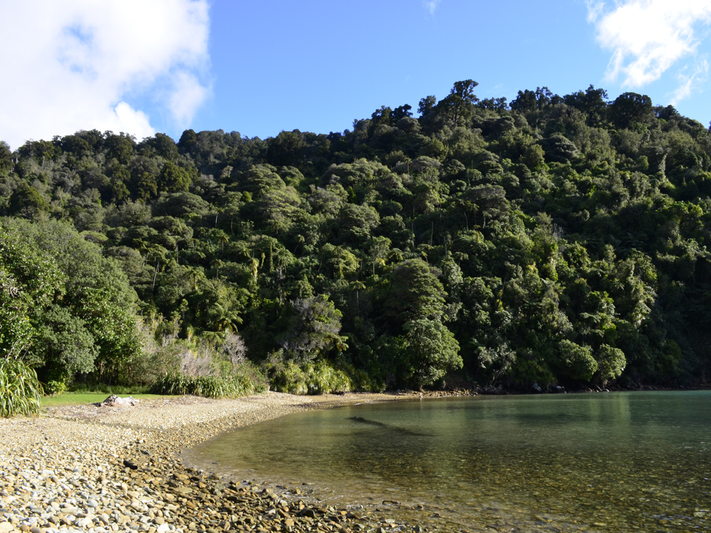
This is first time we'd been able to get to the shore since Ship Cove
On the whole I'm glad to have done the walk as it offered stunning views of the Marlborough Sounds but I wouldn't say it was an essential thing to go out of your way to do unless you happen to be in Picton or are passing through the Marlborough Region. In total, it took us 4 hours 50 minutes to do the walk from Ship Cove to Endeavour Inlet, including stops for lunch, climbing over a mini obstacle course and taking plenty of photos!
One of several storm damaged trees blocking out path
There's no turning back now...
Lizzie having a well earned beer in Furneaux Lodge
We were a little disappointed that we didn't see any dolphins in the Sounds on our journey via the water taxi, but at least we were able to walk the track in the first place, so I guess you can't have it all!