When we originally visited Rotorua on our first trip to New Zealand, we were limited to the attractions that we could see because we didn't have our own transport and also by a lack of funds. This time round we're able to explore further outside of Rotorua even if we don't have all the money we need to see everything! However, this isn't necessarily a problem as it's quite a good thing that we're being more selective as the admissions to a lot of sights such as the Hell's Gate (Tikitere) Thermal Area, Waumangu Volcanic Valley and Te Wairoa (or the Buried Village) can cost from $30 each and we've only got so much money and time to spend in the region.
Also competing for your hard-earned dollars are various Māori "cultural experiences and performances", which to be honest feel a bit contrived in the sense that the Māori groups in Rotorua are cashing in on their heritage more than anywhere we've been to on the North Island. Having already been to Te Whakarewarewa Thermal Reserve and Te Puia we decided just to try a different thermal area, Wai-O-Tapu, as it has some of the most unique and spectacular volcanic wonders in the region, especially as the area is associated with volcanic activity dating back about 160,000 years.
Waiotapu, which means "sacred waters" in Māori, is located 27km south of Rotoua, on the Thermal Explorer Highway (State Highway 5). It's an geothermal area at the southern end of the Okataina Volcanic Centre, on the edge of the largest volcanic caldera (depression), just north of the Reporoa caldera in the Taupō Volcanic Zone. Wai-O-Tapu is considered to be one of New Zealand’s most colourful and diverse geothermal attractions, as it is set within a natural bush setting. The barren landscapes give you an impression that only the hardiest of plant life can grow here.
Starting off at the visitor centre, the first thermal attraction to see at Wai-O-Tapu was actually in a separate area towards the Lady Knox Geyser, which was a short drive back towards the way out. The geyser is named after Lady Constance Knox, the daughter of the then 15th Governer of New Zealand, Uchter Knox.
Lizzie by Lady Knox before the big eruption
The spout is made of rocks placed around the base of the spring to enhance the eruption, by the inmates from a nearby prison who first discovered the geyser in 1901. Over the years silica from the constant eruptions has built up to give a white cone-shaped appearance. Below the geyser are two chambers which hold 26,000 litres of water. At approx. 10.15am everyday a staff member pours a packet of surfactant into the vent so the geyser performs on cue. After about 5 mins, the surfactant eventually changes the surface tension of the two chambers, which releases the pressure of the geyser sending the water between 10 - 20 metres into the air during the initial eruption. The whole event seemed tad artificial especially since we've visited Old Faithful Geyser in Yellowstone National Park (home to half of the world's total number of geysers in its nine geyser basins) and waited patiently for Old Faithful to erupt, but I can understand if people want to see Lady Knox go off consistently as the natural cycle of the geyser is between 24 - 72 hours!
The guide in the following video explains the whole process of geyser in more detail:
Thar she blows!
Once we were finished at the Lady Knox Geyser we headed back to the visitor centre, to begin the walk round the grounds of Wai-O-Tapu. The first of the sights within the geothermal area were the Weather Pool and a series of collapsed craters. Some of the craters are up to 50 metres in diameter and 20 metres deep. Several of the craters contain hot water springs and most have sulphur deposits formed by volcanic gases. The most recent crater to be formed was the Thunder Crater, which collapsed in 1968.
Looking into the depths of the Thunder Crater
The bubbling acidic spring of the Thunder Crater
Down by the Devils-Ink Pots (a seris of bubbling mud pools of crude oil and graphite) we spotted the cat we met at the visitor centre and imaginatively named "Geothermal Cat"! He didn't have a care in the world as he was wondering through all hissing and rumbling silica mounds looking for a warm place to sit on!
Me with Geothermal Cat at the visitor's centre
With so many warm spots to pick, Geothermal Cat is spoilt for choice
Moving onto the Artist's Palette there was a lookout where you could look down on this pool where water overflowing from the Champagne Pool leaves mineral deposits in a variety of bold colours around the pool. As you walk down to the sinter terraces, there's a boardwalk which skirts the Artist's Palette on one side and on otherside the Primrose Terrace - the largest actively formed sinter terraces in New Zealand.
The Artisit's Palette boardwalk and Primrose Terrace in the background
The sulphur rich deposits of the Artist's Palette
The Primrose Terrace covers an area of approx. 3 acres
This fragile terrace has been formed over the last 700 years
The wide range of colours seen throughout the reserve are due to different mineral elements with the following colours consisting of:
Green - Colloidal sulphur/ ferrous salts
Orange - Antimony
White - Silica
Yellow - Sulphur
Red/ brown - Iron oxide
Black - Sulphur and carbon
The reddish-brown colour on the vegetation is known as Trentepohlia
Next was the multi-hued Champagne Pool, which is one of the most unique springs in the world. Formed by a hydrothermal eruption 700 years ago, it's 65 metres in diameter and 62 metres deep. The surface temperature of the bottle-green water fringed by an orange ledge is 74°C and contains numerous minerals such as gold, silver, mercury, sulphur, arsenic, thalliumm, antimony, amongst others, with bubbles of carbon dioxide breaking at the surface. The water discharged from the Champagne Pool flows across a sinter-encrusted flat, with a range of colours caused by mineral precipitation and microorganisms.
The Champagne Pool is somewhere in the steam behind Lizzie
The orange hue is caused by orpiment and realgar - sulfides of arsenic
Thermophillic microorganisms live within the edge of the pool
Walking between the Wai-O-Tapu Geyser and the Alum Cliffs there were several fantail birds (Pīwakawaka) flying around and chirping as we walked passed. Although, we've seen them quite a few times in the forests since we've been here, I've never seen so many flitting around from perch to perch in such a desolate place - it was almost like they thrived in the harsh environment. The fantails are one of our favourite birds in NZ as they're full of character, displaying their tails by constantly opening and closing them, and the noises they make remind me of a squeaky dog toy!
View towards the Wai-O-Tapu Geyser and Alum Cliffs
Pīwakawaka (Rhipidura fuliginosa)
Fantails play prominent roles in Māori legends
Sulphur Cave - yes it did really smell that bad at times...
\
Sulphur deposits in a geothermal spring
At the very end of the reserve you reach Lake Ngakoro (the grandfather) which covers 12 hectares and was formed after an eruption more than 700 years ago. The green lake looks like something out of Jurassic Park as it takes the water that flows across the Frying Pan Flat from the Champagne Pool before tumbling over a small waterfall.
Steam rising across the left shore shows the area is geothermally active!
Lake Ngakoro waterfall
Walking around the native bush walk we caught the first glimpse of a snow capped mountain looking over in the direction of Tongariro National Park, it's a pretty exciting thing for me as I've never see anything like this before...
Overlooking the Oyster Pool and Frying Pan Flat
One of our favourite parts of the reserve was right at the end where we saw a crater filled with luminous green water, called the "Devil's Bath"! It seemed unreal but this was the natural colour of the water as it has been stained by the excess water from the Champagne Pool mixing sulphur and ferrous salts.
This picture hasn't been photoshopped, this is how the pool really looks
As you drive back along the main road there is a short detour to huge boiling mud pool, which is possibly one of the most violent mud pools I've ever seen! This was the site of a large mud volcano which was destroyed through erosion in the 1920′s.
Lying 24 kilometres southeast of Rotorua is Mt Tarawera, a curious-looking mountain, which holds major historical significance for the area in that it was responsible for New Zealand's largest dome volcano eruption and also the country's deadliest eruption. Early Māori and the Europeans who arrived in the 1800's did not realise that Mt Tarawera was an active volcano. At 1111m high, the jagged peaks of Mt Tarawera are made up three domes: Wahanga (bursting open), Ruawahia (the split cave or hole) and Tarawera (burnt cliffs or peaks). On 10th June 1886, the long-dormant Mount Tarawera erupted violently and beneath Lake Rotomahana, a deadly mixture of water, magma and gas exploded in a chain of eruptions, which created the Waimangu Volcanic Valley as well as destroying the famous Pink and White Terraces that used to cascade down to Lake Rotomahana. The spectacular terraces used to be the biggest sinter formation in New Zealand drawing in tourists to the region before their destruction.
The lake was substantially affected by the eruption and the site where the Pink and White Terraces had once stood became a deep crater over a 100 metres deep. Over time this filled with water and formed a new Lake Rotomahana, much larger than the first. The eruption also formed many new geothermal features, including Waimangu Geyser, the largest in the world, and the largest hot spring in New Zealand, Frying Pan Lake.
Surrounding Māori villages such as Te Wairoa (now known as the Burried Village) were also dramatically showered in tonnes of ash and mud. Although, the final death toll will never been known, it is estimated that between 108 - 120 people perished in what remains the largest eruption in New Zealand since European settlement.
Today, Mt Tarawera is a very different place with a peaceful lake, which has natural hot pools that fringe the lake and even a hot water beach.
To get to Lake Tarawera from Waiotapu, we had to drive all the way back to Rotorua and then back out via the Tarawera Road, past the rather the uninspiring Blue (Tikitapu) and Green (Rotokakahi) Lakes. Having been spoilt with all the tones and colours of Wai-O-Tapu , the lakes don't evoke images of the colours they're named after! To be honest, they're nothing more than recreational lakes, which might have been nice to do some walks from if we had the time but they were nothing special.
Going down to the lake at Tarawera Landing, we were only able to get down to the lakefront, as the Tarawera Trail wasn't open to the public and no date had been set by the Tarawera Trail Trust. Instead, we drove back up to a roadside lookout which gave us spectacular views across the lake.
Lake Tarawera and the mountain from Tarawera Landing
I don't really, I was just paraphrasing a famous film (it's Apocalypse Now for the uneducated) - I actually can't stand it but hey this Rotorua, they don't call it "Sulphur City" for nothing! Rotorua is famous for all it's eggy smells due a huge amount of geothermal activity happening in the Taupō Volanic Zone, as a result hydrogen sulphide (H2S) gas is transported to the surface of the earth's crust causing the air to smell like rotten eggs, which from time to time can be a little overwhelming!
Compared to the Bay of Islands, it definitely felt a lot colder down here than in Kerikeri, where we were spoilt with an extended run of warmer weather compared to the rest of New Zealand, but that wasn't going to stop us enjoying Rotorua as we've been hearing that the South Island is even colder still!
To refamiliarise ourselves with the city centre we took a brief walk around the somewhat featureless grid system before heading over to the Government Gardens (originally known as Paepaekumana), east of the Central Business District. The CBD seemed a lot more run down than how I remembered it, however, I can't quite put my finger on it. I'm not sure if I'm just remembering Rotorua with rose tinted glasses or if we've been to some nicer places on our second time round in NZ...
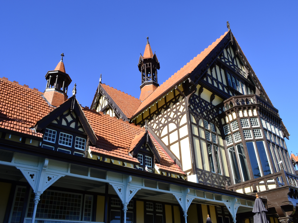
The Government Gardens is a site of legendary and historical importance to local Māori people, as numerous significant battles have taken place there. In the late 1800s, the Māori gifted 50 acres of this land to the British Crown from the Te Arawa tribe, however, the scrub-covered land was cleared and formal gardens planted in its place. Several large trees from those early days remain, including multi-trunked Japanese firs and an unusual Californian weeping redwood. The Government of the day also had a grand vision for the area. As early as the late 1870s it was viewed and developed by the Crown as an antipodean version of a great European spa town. Today, the centre piece of the Government Gardens is the grand mock-Tudor museum which was originally constructed as a spa retreat in 1908.
The ancestral tōtara carvings around the gardens were presented by the Ngāti Whakaue people
The timber-framed Rotorua Museum used to be the old Bath House
The Blue Baths building is a rare example of a Spanish Mission-style bath house
Nice impression Lizzie!
One of our favourite lakeside walks so far is down by the edge of Lake Rotorua, round to Motutara Point and Sulphur Bay. Unlike at Lake Taupō you can actually get down to the water's edge. The lake is in fact a partially filled part of the volcano caldera, which was formed 230,000 years ago by a huge ignimbrite eruption! There's an island in the middle of the lake called Mokoia Island, which was the romantic setting for the Māori tale of Hinemoa and Tutanekai, an old local love story.
The Lakeland Queen paddle steamer
Mokoia Island is possibly New Zealand's best-known lake island
Pied shags (Phalacrocorax varius) in the trees at Motutara Point
Tutanekai lived on Mokoia Island many generations ago, and was the stepson of a great rangatira (chief). Hinemoa lived on the mainland and was the sacred daughter of two rangatira (Te Umukaria and his wife, Hinemaru). She lived in a special house in Owhata, on the eastern shore of the lake and was guarded by female attendants. During an annual meeting of the iwi (tribes), Tutanekai and Hinemoa met and fell in love, but they kept it a secret as they knew it would be forbidden. After the meeting, Tutanekai returned to Mokoia Island, but the music from his flute drifted across the lake to where Hinemoa waited. Hinemoa's people had become suspicious, so they dragged the waka (canoes) high up onto the beach each night to prevent her from rowing across the lake. However, Hinemoa was so determined to be with her love that despite the distance, she decided to swim the lake. She tied three empty gourds under each arm and set off through the cold, dark water using the sound of Tutanekai's flute to guide her. When she reached Mokoia Island, she was cold and tired so she rested in a hot pool. When one of Tutanekai's slaves came to fetch water, she demanded the gourd he carried, drank from it and then smashed it on the rocks. She did this twice, before Tutanekai stormed down to the hot pool to see who had insulted him in this way. But when he saw it was Hinemoa, he pulled her from the pool, put a cloak around her and took her back to his whare (house). In the morning, when four feet where seen in the whare instead of two (!), news spread that Tutanekai and Hinemoa had been wed. Their families made peace, and they lived happily together and had many distinguished descendants.
The lake and Mokoia Island are an outstanding habitat for water birds
At the west of the lakefront is Ohinemutu village, which is a suburb of Rotorua but very much retains a sense of importance. Ohinemutu was the region's original Ngāti Whakaue settlement, however, today you can see how Māori and European cultures have collaborated. Towards the lake's edge is the magnificently decorated St. Faith's Anglican Church. Inside the church, Māori design stained glass windows and carvings plus tukutuku (woven panels) add a unique dimension to the European Tudor-style architecture. An imaginative etched window has Jesus in a traditional Māori cloak, positioned in such a way that he appears to be walking on the water of the lake.
St. Faith's Anglican Church seamlessly blends Māori and European cultures
Two of the best free places in Rotorua to see boiling mud pools, sulphur vents and fumeroles as well as barren landscapes are at Sulphur Point (Te Kauanga) and Kuirau Park, which is right next to the city centre. Sulphur Bay is the southern most bay on Lake Rotorua, which is a warm sulpherous area lying on top of an active geothermal field. In particular, the thin crust around Sulphur Point makes it quite a dangerous place to be if you don't stick to the footpaths.
Many of the best geothermal attractions in the area lie outside of Rotorua and we're hoping to see some of the more dramatic volcanic areas, especially now have our own transport to get around as we were limited to how far we could travel the last time we stayed here.
Cameron's laughing gas pool at Sulphur Point (Te Kauanga)
The milky colour of the water is due to suspended sulphur particles
A section of the Te Arikiroa walk round from Sulphur Bay
On a separate day we drove out to the Whakarewarewa Forest 3km southeast of the city centre to walk along the Pohaturoa Track up to the Trig (upper) and Whaka (lower) lookouts, where we could lookout over Te Whakarewarewa Thermal Reserve (or Te Whakarewarewa o te Ope Taua a Wahiao as the area is fully known!). At one point we were able to watch the Pohutu Geyser ("big splash") spouting steaming water 30m into the air.
The view gives you a better sense that the city is built on an old lake bed
A free show of the Pohutu Geyser from the Whaka lookout
Steam rising across the Te Whakarewarewa thermal field
Within the forest there is an impressive Redwood Grove, which was planted in 1899 as an experiment to see which exotic species could be grown successfully in New Zealand for timber. Not many of the 170 tree species survived, but the redwoods were found to grow three times faster than in their native California and some of the tallest trees now reach the heights of around 60m.
California coastal redwood towering above the forest
A naturally occurring thermal pond, the sulphur content turns any vegetation a powdery white colour
A whekī or rough tree fern under the canopy of the redwoods
Kerikeri has been very good to us, the weather generally has been great in the subtropical "winterless north", we've made some great friends at work. On the whole we've been truly spoilt with our stay at the Kerikeri Farm Hostel, which really has felt like home but sadly now it's time for us to go. We'll especially miss our honorary dogs at Kerikeri Farm Hostel, Nika and Weewee...
Nika, please don't leave me!
Lizzie with our other favourite lady, Weewee
Our plan for now is to make our way to the South Island but the first stop on the long way down is via Rotorua. Along the way we decided to stop off in the small town of Paeroa in the Southern Coromandel, as it's the birthplace of Lemon and Paeroa (L&P) - an iconic homegrown, but no longer home-owned (now owned by Coca-Cola Amatil) soft drink that we've become slightly addicted to!
Traditionally, L&P is made by combining lemon juice with carbonated mineral water sourced from Paeroa, which gives the drink it's unique flavour. The taste is quite hard to describe as it's not like lemonade, but its equally as refreshing.
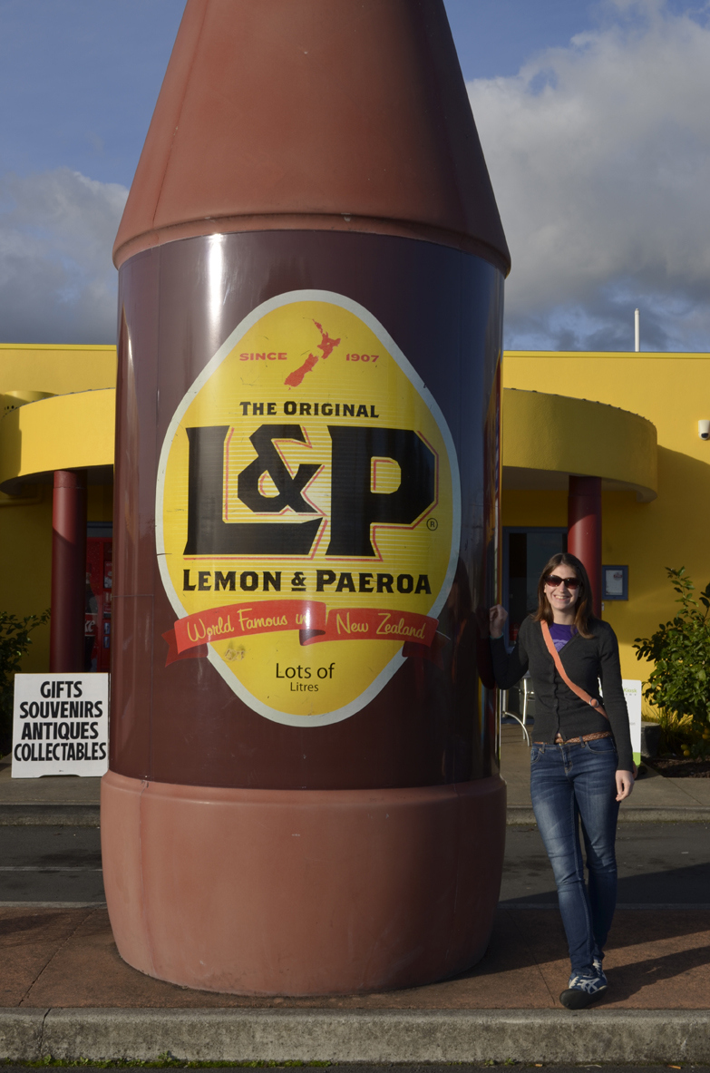
In homage to the delectable drink we stopped off at the L&P café where you can sample some L&P ice cream and see a replica of the iconic L&P bottle outside, however, the original giant "bottle" can be found in Ohinemuri Park on the corner of Normanby and Te Aroha Roads at the eastern entrance of State Highway 2.
The only place in New Zealand where you can sample L&P ice cream
A replica of the iconic L&P bottle beckons visitors passing through
Lizzie standing next to the 5.8m bottle
The inspiration for the eye-catching L&P bottle came about after a replica rocket was assembled for Paeroa's 1967 Christmas promotion "Rocket into Christmas". The iconic 23ft high monument is a favourite with New Zealanders and overseas visitors.
The giant L&P bottle sports the label design used from the 1970s to the 1990s
Mosaic of a cut lemon and gas bubbles in Ohinemuri Park
The modern bottle design sports the paradoxical slogan "World famous in New Zealand", which is a bit of a tongue-in-cheek way of New Zealanders laughing at themselves!
I seriously hope you can buy this drink back at home someday, as I'm really surprised that such a great drink hasn't become more commercial abroad. It reminds me of the time when I got hooked to A&W root beer when we travelled across the United States. I still hanker for a taste every now and again...!