Being the seasoned "Queenstowners" we have become, we've been able to steer clear a lot of the main tourist traps and dig a little deeper into what the local area has to offer, and appreciate the natural beauty of the Wakatipu region. Most of the visitors passing through only really get to experience just the tip of the iceberg of what Queenstown has to offer. The Wakatipu area caters to a range of different walking experiences from bush walks and lake views to historic trails and challenging alpine traverses. As we've been in Queenstown for a while and have tried several of the walks covered in the excellent Department of Conservation brochure, "
Wakatipu Walks", I decided to write a summary of four of the best walks that we did.
- this historic walking track is found 10km from Queenstown on the Glenorchy Road at the Mt Crichton Scenic Reserve. This track can be walked in either direction but we started off by crossing a footbridge over Twelve Mile Creek before we following it back upstream as we climbed up alongside a gorge that passed through strands of mountain beech and mänuka forest. Once we got up high above the creek couldn't really see the mountains through the forest.
 |
| Don't get too close to the edge of the gorge! |
 |
| On of the many crossings over the winding Twelve Mile Creek |
Eventually we reached an impressive sluiced canyon, which marked a time where 19
th Century gold miners had shaped the landscape by removing as much as 1.8 million cubic metres of rock to create a large open space. Slowly but surely the surrounding beech forest has started to reclaim the site, however, the contour of the land has been permanently altered!
 |
| Gold-bearing gravel was washed off these cliffs towards the tailrace |
It was in this clearing that we caught our first properly glimpse of Mt Crichton (1,870m) - the most prominent peak in the scenic reserve. A little further ahead a side track lead us to an impressive rock fissure, which was once used by the gold miners as a tail race tunnel.
 |
| Nearly 240m3 of rock was laboriously chiselled and blasted to make this tailrace tunnel |
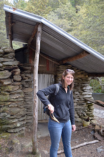
Continuing along on the main track we continued to follow the gorge high above Twelve Mile Creek (which is sourced by Lake Isobel at the top of Mt Crichton) before eventually reaching the historic Sam Summers Hut - a relic of the gold rush era. Sam Summers was a prospector who mined in Twelve Mile Creek on-and-off for 30 years, where he built a hut with his brothers in 1930. Sam helped provide for his sister and nine brothers by prospecting and hunting. Sam eventually left his hut to go to war but often returned to visit it, walking all the way from Queenstown. While other prospector's shelters have crumbled away, Sam's hut has been regularly repaired and maintained for over 80 years - it can still be used as basic accommodation even today! Sam Summers passed away in 1997, aged 92 but his hut serves a strong historical link to the region's gold mining heritage.


Following Twelve Creek past an impressive waterfall, it wasn't long before we were climbing up again where were able to catch a fleeting view of Walter Peak (1,800m) through the tree line above the sluiced canyon before we reached a short side track that connects with Lake Dispute. From here we could walk down to the lakeside and pick up the track to Moke Lake if we really wanted to make a day of it but we decided the view was enough for us and that we wanted to finish off walking the loop.
 |
| A lush waterfall cascade near Sam Summers Hut |
 |
| A snow-capped Walter Peak high above the sluiced canyon |
 |
| The side track connects with Lake Dispute from above the lake |
 |
| A panoramic view of Lake Dispute - click here to view in hi-res |
We knew it wasn't much further to end of track as we were on the opposite side of the sluiced canyon where we got spectacular views of Mt Crichton which had a small dusting of snow on the peak and across the scenic reserve. But before we could finish there was the small matter of climbing over a tree which had been obviously blown over in a storm!
 |
| The peak of Mt Crichton on the left |
 |
| Lizzie ready to tackle the tree blocking our path! |
 |
| A view of the sluiced canyon from the other side of the loop |
 |
| Panoramic view of Mt Crichton and across the sluiced canyon- click here to view in hi-res |
The walk took us just over 3 hours in total, which included the side tour of Lake Dispute and stopping off for a quick lunch. This is somewhere between the 2-4 hour estimate by the Department of Conservation, but the lower end of the timings could take into account how long it takes to run the loop as there were a lot of joggers out and about.
Moke Lake Loop Track - Moke Lake is also 10km drive from Queenstown like the Mt Crichton Loop Track, with the last 3km of the drive along an unsealed gravel road through the Closeburn Station alongside Wedge Peak (1,086m) and past Lake Kirkpatrick. We eventually reached Moke Lake where we got a fantastic view of the Williamsons Spur and Ben Lomond in the backdrop.
 |
| A panorama of Moke Lake with Wedge Peak in the centre - click here to view in hi-res |
Walking anticlockwise around the track, we passed a young
Little Pied Cormorant perched on a broken jetty before we the trail started to climb above the lake.
 |
| A juvenile Little Pied Cormorant (Microcarbo melanoleucos) |
At the southern end, there was a short boardwalk over a small area of wetland before the track started undulating again where we skirted the base of Wedge Peak on the return section of the loop.
 |
| Looking across to Ben Lomond |
 |
| View of the southern end where there is a boardwalk over wetland |
 |
| Across the lake looking back towards Moke Spur |
 |
| A panoramic view of the southern end of the lake along the Williamsons Spur - click here to view in hi-res |
 |
| A short boardwalk with a the tip of the Williamsons Spur to the right |
The Department of Conservation estimate that the Moke Lake loop track takes two and half hours on average to walk around the lake, however, it took us just over two hours with quite a big break for lunch! It was a nice enough walk and a good spot for families but I felt the Mt Crichton Loop Track had more to offer in terms of points of interest.
Twelve Mile Delta - The Central Otago region provided several prominent Middle-Earth locations for the Lord of the Rings movie trilogy, in particular with one particular scene from the Two Towers ("Of Herbs and Stewed Rabbit") just on our doorstep! Being the Lord of Rings geeks that we are it would have been rude not to check this out at Twelve Mile Delta not far from the Mt Crichton Loop Track.
We first learnt about the scenes from the Two Towers from the
Lord of the Rings Location Guidebook written (and signed!) by Ian Brodie, as the Queenstown area has a number of other significant locations including the Pillars of the Kings and the River Anduin at the Kawarau River, the Ford of Bruinen and the Gladden Fields at Arrowtown, and various locations at Deer Park Heights which has sadly been not open to the public for a number of years... Lord of the Rings locations can also be found on the Department of Conservation website as mentioned in my
Glenorchy post.
 |
| Lizzie looking very geeky with her LOTR locations guide! |
Twelve Mile Delta itself is picturesque with dramatic views of the Lake Wakatipu and surrounding mountains. Twelve Mile Creek is also one of five places you can fossick for gold in Otago. There are two areas at Twelve Mile Delta used to portray Ithilien; the first is where Sam, Frodo and Sméagol watch the battle between the Rangers of Ithilien and the men of Harad. The second scene is where Sam and Smeágol are comparing notes on the best way to eat a brace of coneys.
 |
| The cliffs of Twelve Mile Delta with Cecil Peak (1,978m) behind |
 |
| Twelve Mile Stream flowing into Lake Wakatipu |
Once we reached the car park at Twelve Mile Delta, there's a walking track near Twelve Mile Stream, from here the bank across the river is where the trio watch the battle. To reach the cliff top we had to follow the walking track to the western end of the river. Crossing a footbridge over a relatively shallow canyon which Twelve Mile Stream rushes through, (it must have been at least a couple of metres deep as the water was crystal clear as you could see all the way to the bottom) there were some canyoning tour groups being taken through the stream.
 |
| The chasm where the canyoning group were exploring Twelve Mile Stream |
The area where Sam is cooking the coneys is another 5-10 minutes from here on the left where the ground is scrubby with tough matagouri bushes.
 |
| "What's 'taters precious?" |
If you carry on round the footpath you'll start ascending up the track and be brought back round to where the Oliphants march through Ithilien. There's a break in the tree line where you get a decent view looking back to Mt Crichton, although you need to be careful as the cliff has a steep drop. If you go any further you'll won't be able to see this anymore and will eventually end up heading towards Bob's Cove.
 |
| The same view without the computer generated Oliphants and army! |
 |
| Mt Crichton is clearly visible in this still |
 |
| The peaks of Mt Critchton and Ben Lomond in the background |
The beauty of having found the location on our own steam was that there was a tour group which shortly followed us, confirming we were indeed had the right location and all it cost us was the price of the book instead of a costly tour! The movie stills above are copyright of New Line Productions.
Ben Lomond Walking Track - Possibly one of the more challenging one days walks you can do in Queenstown is the Ben Lomond (Te taumata-o-Hakitekura) track which takes you all the way to the 1,748m summit. Ben Lomond was named after it's namesake on the eastern shore of Loch Lomond in Scotland by shepherd Duncan McAusland in the mid 1800s.
We walked from the very bottom of town via the tiki trail all the way up to the Skyline gondola building, which took us about 50 mins to walk. Alternatively, you can pay for the gondola to the top which takes 10 minutes but it's not as fun (or as tiring)!
 |
| We couldn't have picked a more perfect start to the day |
From the Skyline complex building we picked up the start of the Ben Lomond track, this is one of two approaches to the track, the other one being at One Mile Creek, near Fernhill. From here we had the option of following the saddle for 1 hour 30 mins or reaching the summit in 2 hours 30 mins.
We were determined to reach the top so we started our long ascent up the dry and dusty dirt track. Looking across to the very tip of Ben Lomond peak it still had the tiniest patches of snow at the top, even as we were moving into summer! Climbing up the saddle we got some sweet views looking down over Queenstown and across Lake Wakatipu. There was also a steady stream of people coming towards us from the summit so we knew it possible for most people to do even though the Department of Conservation considers it one of the more "demanding" day walks.
 |
| The vegetation moves from Douglas Fir forest to open tussock grasslands |
 |
| Ben Lomond panorama - click here to view in hi-res |
 |
| A large rock slip across the path of the saddle |
 |
| Looking East over to Coronet Peak and Crown Range on the horizon |
 |
| A magnificent view across to Kelvin Heights and the Remarkables |
 |
| Only another 3 hours back to the home via the Moonlight Track! |
After about an hour and half of walking in the blazing sun with nowhere to provide shade, we reached the end of the Ben Lomond saddle where there a bench to sit on so we could take in the truly magnificent view across the valley to the white peaks of the Richardson Mountains, past the Harris Mountains and all the way to Mt Aspiring National Park. From here it was supposedly going to take us another hour to reach the summit but this part of the walk would be the toughest as the path to the top of Ben Lomond is very steep.
 |
| This doesn't really the view any justice, plus there's two people in the way! |
 |
| The summit of Ben Lomond is deceptively close in the picture... |
 |
| Connected to Ben Lomond is the twin peak of Bowen Peak (1,631m) |
Coming up the saddle it like felt we were making good progress but the climb to the summit seemed to go on forever but once we reached 1,748m summit the amazing vistas more than made up for it! A couple of times as we approached the summit I could feel my head spinning a little as the path came close to the edge of a few rocky outcrops but it wasn't that bad a track to climb, but possibly not the best walk to do if you don't have a head for heights!
 |
| Lizzie catching a breath on the exhausting climb to the top |
 |
| View over to the Richardson Mountains and Bowen Peak - click here to view in hi-res |
At the summit there wasn't much room for too many people to stop and have a rest but the views are some of the best you can get in the area, looking down Queenstown and across the lake to the Remarkables to the South and South East, Bowen Peak and Coronet Peak to the East, Moke Lake beneath and Mt Crichton to the West and the Richardson and Harris Mountains to the North - a truly fantastic reward for a such a demanding climb!
 |
| Reaching spiritual enlightenment on the top of Ben Lomond! |
 |
| The distinctive peak of Mt Aspiring/ Tititea (3,027m) in the centre |
 |
| The Centaur Peaks over towards Glenorchy |
 |
| Mt Earnslaw (2, 819m) aka the Misty Mountains from LOTR! |
 |
| A little closer to home, Coronet Peak (1,651m) |
 |
| Panoramic view of the Wakatipu Basin from the top of Ben Lomond - click here to view in hi-res |
 |
| View of Lake Wakatipu towards the Richardson Mountains - click here to view in hi-res |
 |
| View from the top of Ben Lomond towards the Crown Range - click here to view in hi-res |
Heading back down it's a little more challenging as our legs we're a bit like jelly and the track a little slippery. Personally, I found that the walk to the top wasn't as bad as coming back down, which wrecked my feet, however, Lizzie would have to disagree in that coming down was far easier than going up! At least I got some well earned blisters!
 |
| We were up higher than the helicopters were flying! |
Once we reached the saddle, we could hear Keas (mountain parrots found in the South Island) screeching in the distance) but couldn't see them. By the time we had walked all the way back to the Skyline gondala building we decided that we had enough of walking and sneaked onto the gondola to get a ride back into town for free and to reward ourselves with a well earned Fergburger! We were really glad that we did the Ben Lomond Track it definitely the most epic of all the walks we've done so far and possibly the highest we ever climbed.


