Having spent the best part of yesterday trying to second guess the weather, deciding whether or not to walk the Queen Charlotte Track, we woke up at 8am and it wasn't looking good as it had been raining the night before and looked really overcast. I was a bit gutted initially as I felt the cost of the water taxi was quite steep for a self-guided walk, so good weather was a definite requirement as the Queen Charlotte Track is reputed to be one of the top ten and finest coastal walking tracks in New Zealand.
The plan for the day was to be dropped off at Ship Cove and walk along a section of the Queen Charlotte Track to Endeavour Inlet where we would be picked up again by the water taxi. The stretch of the track we're walking is approximately 15km long, although the entire track is 71km in length which can be done in 3-5 days of tramping (staying in overnight accommodation along the way).
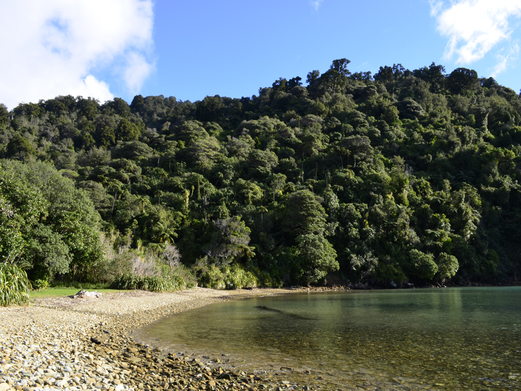
The Queen Charlotte Sound is the best known of the three Sounds (Pelorus Sound and Kenepuru Sound are the other two) and is a labyrinth of drowned valleys enclosed by moody picturesque bays, deserted sandy coves and islands. The journey up Queen Charlotte Sound (Totaranui) from Picton to Ship Cove (Meretoto) took roughly an hour, although the last 20 minutes of the trip were a little choppier as we were going through the swell.
Looking from Picton Habour towards the Queen Charlotte Sound
The bush clad shoreline of the Queen Charlotte Sound
The numerous bays, coves and islands of the Sound
On 16th January 1770, the Endeavour, under the command of the then Lieutenant James Cook, dropped anchor in the bay which he would name Ship Cove. This would be the first of several visits by ships under Cook's command on his three voyages. He spent more time here than anywhere else in New Zealand and it was the first place that sustained contact between the Māori and the British took place. The Māori were keen to trade for European goods while Cook's crew observed and engaged in the Māori culture and way of life.
Captain Cook had explored more of the earth's surface than anyone else before him in history and became the first European to land in New Zealand and the east coast of Australia. However, it was Cook's travels that spurred on the colonisation of the Pacific, which brought with it missionaries, whalers, traders, settlers and even death, and ultimately impacted on Pacific Island cultures. As a result, many indigenous cultures detest Cook for his achievements as they view him as the villain who introduced disease, dispossession and other ills to the Pacific.
Whatever view you hold, Captain James Cook remains one of the most significant figures in the shaping of the modern Pacific.
View of Motuara Island from Ship Cove
A large concrete monument commemorates Captain Cook's visits.
It's easy to see why Ship Cove was one of Cook's favourite places
Crossing the stream at Ship Cove
Māori carvings welcome visitors to the cove
From here the reserve is the starting point for everyone walking the Queen Charlotte Track, which is actually part of Te Araroa(the long pathway) - a walking trail from Cape Rēinga all the way down to Bluff, which opened on 3rd December 2011. Heading south from the Cook monument, the first couple of kilometers of the track were undulating with quite a steep initial climb. It must have rained a lot overnight as the track was quite boggy and damp underfoot, and the clay slopes were really slippery. At one point a fallen tree had completely blocked the path - it must have fallen quite recently as the branches looked freshly broken.
A deep canopy shades the profusion of tree ferns and other vegetation
One of the many streams crossing the track
After about 45 minutes of walking we reached a lookout that offered pleasant respite and good views of Motuara Island and the outer Queen Charlotte Sound. It was from Motuara Island that James Cook declared sovereignty over the South Island. Cook also renamed Totaranui the Queen Charlotte Sound in honour of King George III's consort. Today, Motuara Island is a bird sanctuary for the South Island robin and the South Island saddle back. It was also round by the lookout that we got our first view of an inquisitive Weka (Gallirallus australis) in the bushes!
Motuara Island on the left and Hippo Island on the right
View over Resolution Bay with Tawa Bay Saddle on the far right
You can just about make out the snowcapped KaikōuraMountains
From here we climbed the Ship Cove/ Resolution Bay Saddle and descended towards Resolution Bay. However, it was a bit disappointing that we couldn't get down close to Resolution Bay itself as we unsure of where the trail would take us if we went off the beaten track, due to a lack of signage.
From Resolution Bay the track followed an old bridle path ascending over a ridge, which would eventually lead down into Endeavour Inlet. The inclining track passed through stands of kamahi and then beech forest as we passed over another saddle.
Some more of the native vegetation of the track
Every now and again you get glimpse of the sea through the tree line
Climbing up the ridge overlooking Resolution Bay
We were literally the only people on the section of track we walked - in the middle of nowhere with no mobile phone coverage! We were surprised when we eventually saw someone walking their dogs. At times it was very tranquil and silent when you paused to take in the solitude of the surroundings, apart from the occasional chirp of a bird or when the trees swayed in the wind. This was shattered as at one point when Lizzie comically fell into a small stream we had to cross and got quite cold and wet in the process!
A sad Lizzie after she stumbled on a loose rock in the stream!
A crystal clear stream that eventually feeds into the Sound
Resolution Bay looking back towards Ship Cove
As mentioned previously, we saw quite a few Wekas (or woodhens) along the walk - they look like a cross between a moorhen and a duck. This flightless bird is a little like a kiwi but slimmer and far less shy. The one we saw was especially tame as it was foraging very close to us in the bush.
This bold Weka didn't have any problems with getting close to us
Wekas are famous for their feisty and curious personalities
As nice a walk as the Queen Charlotte Track was to do, it was difficult to judge the progress we were making along the track as there were no markers and very few useful signs. Our final destination was Furneaux Lodge at the head of Endeavour Inlet on the eastern side of the bay. The last section of the walk involved us walking through a lots of regenerating native bush, with a predominance of manuka, kanuka and five finger vegetation.
Endeavour Inlet was one of Captain Cook's favourite anchorages
This is first time we'd been able to get to the shore since Ship Cove
On the whole I'm glad to have done the walk as it offered stunning views of the Marlborough Sounds but I wouldn't say it was an essential thing to go out of your way to do unless you happen to be in Picton or are passing through the Marlborough Region. In total, it took us 4 hours 50 minutes to do the walk from Ship Cove to Endeavour Inlet, including stops for lunch, climbing over a mini obstacle course and taking plenty of photos!
One of several storm damaged trees blocking out path
There's no turning back now...
Lizzie having a well earned beer in Furneaux Lodge
We were a little disappointed that we didn't see any dolphins in the Sounds on our journey via the water taxi, but at least we were able to walk the track in the first place, so I guess you can't have it all!
When we originally visited Rotorua on our first trip to New Zealand, we were limited to the attractions that we could see because we didn't have our own transport and also by a lack of funds. This time round we're able to explore further outside of Rotorua even if we don't have all the money we need to see everything! However, this isn't necessarily a problem as it's quite a good thing that we're being more selective as the admissions to a lot of sights such as the Hell's Gate (Tikitere) Thermal Area, Waumangu Volcanic Valley and Te Wairoa (or the Buried Village) can cost from $30 each and we've only got so much money and time to spend in the region.
Also competing for your hard-earned dollars are various Māori "cultural experiences and performances", which to be honest feel a bit contrived in the sense that the Māori groups in Rotorua are cashing in on their heritage more than anywhere we've been to on the North Island. Having already been to Te Whakarewarewa Thermal Reserve and Te Puia we decided just to try a different thermal area, Wai-O-Tapu, as it has some of the most unique and spectacular volcanic wonders in the region, especially as the area is associated with volcanic activity dating back about 160,000 years.
Waiotapu, which means "sacred waters" in Māori, is located 27km south of Rotoua, on the Thermal Explorer Highway (State Highway 5). It's an geothermal area at the southern end of the Okataina Volcanic Centre, on the edge of the largest volcanic caldera (depression), just north of the Reporoa caldera in the Taupō Volcanic Zone. Wai-O-Tapu is considered to be one of New Zealand’s most colourful and diverse geothermal attractions, as it is set within a natural bush setting. The barren landscapes give you an impression that only the hardiest of plant life can grow here.
Starting off at the visitor centre, the first thermal attraction to see at Wai-O-Tapu was actually in a separate area towards the Lady Knox Geyser, which was a short drive back towards the way out. The geyser is named after Lady Constance Knox, the daughter of the then 15th Governer of New Zealand, Uchter Knox.
Lizzie by Lady Knox before the big eruption
The spout is made of rocks placed around the base of the spring to enhance the eruption, by the inmates from a nearby prison who first discovered the geyser in 1901. Over the years silica from the constant eruptions has built up to give a white cone-shaped appearance. Below the geyser are two chambers which hold 26,000 litres of water. At approx. 10.15am everyday a staff member pours a packet of surfactant into the vent so the geyser performs on cue. After about 5 mins, the surfactant eventually changes the surface tension of the two chambers, which releases the pressure of the geyser sending the water between 10 - 20 metres into the air during the initial eruption. The whole event seemed tad artificial especially since we've visited Old Faithful Geyser in Yellowstone National Park (home to half of the world's total number of geysers in its nine geyser basins) and waited patiently for Old Faithful to erupt, but I can understand if people want to see Lady Knox go off consistently as the natural cycle of the geyser is between 24 - 72 hours!
The guide in the following video explains the whole process of geyser in more detail:
Thar she blows!
Once we were finished at the Lady Knox Geyser we headed back to the visitor centre, to begin the walk round the grounds of Wai-O-Tapu. The first of the sights within the geothermal area were the Weather Pool and a series of collapsed craters. Some of the craters are up to 50 metres in diameter and 20 metres deep. Several of the craters contain hot water springs and most have sulphur deposits formed by volcanic gases. The most recent crater to be formed was the Thunder Crater, which collapsed in 1968.
Looking into the depths of the Thunder Crater
The bubbling acidic spring of the Thunder Crater
Down by the Devils-Ink Pots (a seris of bubbling mud pools of crude oil and graphite) we spotted the cat we met at the visitor centre and imaginatively named "Geothermal Cat"! He didn't have a care in the world as he was wondering through all hissing and rumbling silica mounds looking for a warm place to sit on!
Me with Geothermal Cat at the visitor's centre
With so many warm spots to pick, Geothermal Cat is spoilt for choice
Moving onto the Artist's Palette there was a lookout where you could look down on this pool where water overflowing from the Champagne Pool leaves mineral deposits in a variety of bold colours around the pool. As you walk down to the sinter terraces, there's a boardwalk which skirts the Artist's Palette on one side and on otherside the Primrose Terrace - the largest actively formed sinter terraces in New Zealand.
The Artisit's Palette boardwalk and Primrose Terrace in the background
The sulphur rich deposits of the Artist's Palette
The Primrose Terrace covers an area of approx. 3 acres
This fragile terrace has been formed over the last 700 years
The wide range of colours seen throughout the reserve are due to different mineral elements with the following colours consisting of:
Green - Colloidal sulphur/ ferrous salts
Orange - Antimony
White - Silica
Yellow - Sulphur
Red/ brown - Iron oxide
Black - Sulphur and carbon
The reddish-brown colour on the vegetation is known as Trentepohlia
Next was the multi-hued Champagne Pool, which is one of the most unique springs in the world. Formed by a hydrothermal eruption 700 years ago, it's 65 metres in diameter and 62 metres deep. The surface temperature of the bottle-green water fringed by an orange ledge is 74°C and contains numerous minerals such as gold, silver, mercury, sulphur, arsenic, thalliumm, antimony, amongst others, with bubbles of carbon dioxide breaking at the surface. The water discharged from the Champagne Pool flows across a sinter-encrusted flat, with a range of colours caused by mineral precipitation and microorganisms.
The Champagne Pool is somewhere in the steam behind Lizzie
The orange hue is caused by orpiment and realgar - sulfides of arsenic
Thermophillic microorganisms live within the edge of the pool
Walking between the Wai-O-Tapu Geyser and the Alum Cliffs there were several fantail birds (Pīwakawaka) flying around and chirping as we walked passed. Although, we've seen them quite a few times in the forests since we've been here, I've never seen so many flitting around from perch to perch in such a desolate place - it was almost like they thrived in the harsh environment. The fantails are one of our favourite birds in NZ as they're full of character, displaying their tails by constantly opening and closing them, and the noises they make remind me of a squeaky dog toy!
View towards the Wai-O-Tapu Geyser and Alum Cliffs
Pīwakawaka (Rhipidura fuliginosa)
Fantails play prominent roles in Māori legends
Sulphur Cave - yes it did really smell that bad at times...
\
Sulphur deposits in a geothermal spring
At the very end of the reserve you reach Lake Ngakoro (the grandfather) which covers 12 hectares and was formed after an eruption more than 700 years ago. The green lake looks like something out of Jurassic Park as it takes the water that flows across the Frying Pan Flat from the Champagne Pool before tumbling over a small waterfall.
Steam rising across the left shore shows the area is geothermally active!
Lake Ngakoro waterfall
Walking around the native bush walk we caught the first glimpse of a snow capped mountain looking over in the direction of Tongariro National Park, it's a pretty exciting thing for me as I've never see anything like this before...
Overlooking the Oyster Pool and Frying Pan Flat
One of our favourite parts of the reserve was right at the end where we saw a crater filled with luminous green water, called the "Devil's Bath"! It seemed unreal but this was the natural colour of the water as it has been stained by the excess water from the Champagne Pool mixing sulphur and ferrous salts.
This picture hasn't been photoshopped, this is how the pool really looks
As you drive back along the main road there is a short detour to huge boiling mud pool, which is possibly one of the most violent mud pools I've ever seen! This was the site of a large mud volcano which was destroyed through erosion in the 1920′s.
Lying 24 kilometres southeast of Rotorua is Mt Tarawera, a curious-looking mountain, which holds major historical significance for the area in that it was responsible for New Zealand's largest dome volcano eruption and also the country's deadliest eruption. Early Māori and the Europeans who arrived in the 1800's did not realise that Mt Tarawera was an active volcano. At 1111m high, the jagged peaks of Mt Tarawera are made up three domes: Wahanga (bursting open), Ruawahia (the split cave or hole) and Tarawera (burnt cliffs or peaks). On 10th June 1886, the long-dormant Mount Tarawera erupted violently and beneath Lake Rotomahana, a deadly mixture of water, magma and gas exploded in a chain of eruptions, which created the Waimangu Volcanic Valley as well as destroying the famous Pink and White Terraces that used to cascade down to Lake Rotomahana. The spectacular terraces used to be the biggest sinter formation in New Zealand drawing in tourists to the region before their destruction.
The lake was substantially affected by the eruption and the site where the Pink and White Terraces had once stood became a deep crater over a 100 metres deep. Over time this filled with water and formed a new Lake Rotomahana, much larger than the first. The eruption also formed many new geothermal features, including Waimangu Geyser, the largest in the world, and the largest hot spring in New Zealand, Frying Pan Lake.
Surrounding Māori villages such as Te Wairoa (now known as the Burried Village) were also dramatically showered in tonnes of ash and mud. Although, the final death toll will never been known, it is estimated that between 108 - 120 people perished in what remains the largest eruption in New Zealand since European settlement.
Today, Mt Tarawera is a very different place with a peaceful lake, which has natural hot pools that fringe the lake and even a hot water beach.
To get to Lake Tarawera from Waiotapu, we had to drive all the way back to Rotorua and then back out via the Tarawera Road, past the rather the uninspiring Blue (Tikitapu) and Green (Rotokakahi) Lakes. Having been spoilt with all the tones and colours of Wai-O-Tapu , the lakes don't evoke images of the colours they're named after! To be honest, they're nothing more than recreational lakes, which might have been nice to do some walks from if we had the time but they were nothing special.
Going down to the lake at Tarawera Landing, we were only able to get down to the lakefront, as the Tarawera Trail wasn't open to the public and no date had been set by the Tarawera Trail Trust. Instead, we drove back up to a roadside lookout which gave us spectacular views across the lake.
Lake Tarawera and the mountain from Tarawera Landing