Showing posts with label Lake Wakatipu. Show all posts

Thursday, 29 November 2012

Glenorchy and Arrowtown

If the hustle and bustle of Queenstown gets too much, then there are a couple of charming, low-key townships which you can visit not too far away. In opposite directions to Queenstown lie the quaint towns of Glenorchy and Arrowtown.

Glenorchy lies at the head of Lake Wakatipu, which is a scenic 40-minute drive (45km) northwest from Queenstown. Glenorchy is the gateway to some of the finest tramping tracks that New Zealand has to offer including a circuit of the Rees and Dart rivers, the Routeburn Track, and the Greenstone and Caples tracks but apart from that, the township itself doesn't really have much to offer.


The area is also the site for the proposed Routeburn tunnel, which would carve an 11km tunnel through Mt Aspiring National Park to provide a more direct route to Milford Sound from Queenstown and reduce the journey times of the day trip, which can currently take up to 12 hours from Queenstown. The proposal has proven controversial as it would threaten the World Heritage Status of both Fiordland and Mt Aspiring National Parks, as well as draw tourism away from Te Anau and increase traffic through Glenorchy, which is essentially an "end of road" destination, thus spoiling the wilderness of the area.

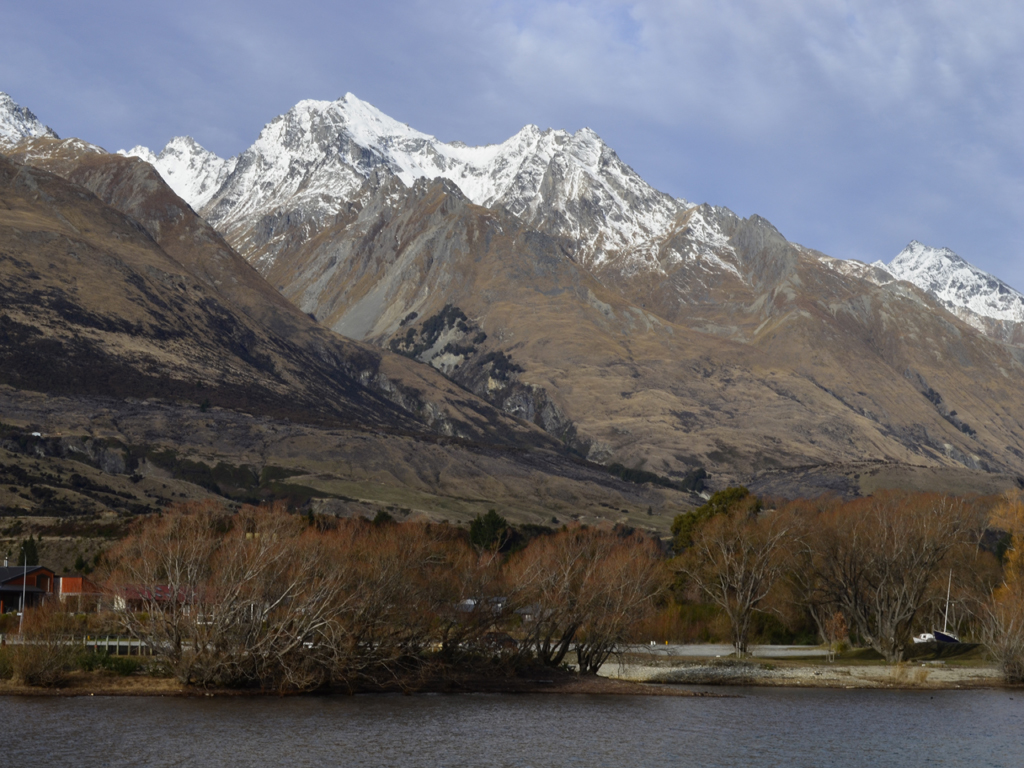
En route to Glenorchy, there are a number of tracks down by Lake Wakatipu for lakeside walks, historic sites, fishing or swimming. We stopped off at Bob's Cove (Te Punatapu) in the Upper Lake Wakatipu Reserve to walk a short nature trail down by the lakeside, which was part of the original bridle track to Glenorchy.

In front of the shore of Bob's Cove with Mt Nicholas and Mt Turnbull


Fortune Cove, or Bob's Cove, derives it's name from Bob Fortune, a boatman who worked for William Rees, who was an early pioneer in the area. It was also the site of a short lived but important lime quarrying and burning industry in Queenstown for agriculture and building materials.

Apparently, Bob's Cove is one of the best places to observe Lake Wakatipu's seiche (a french word, used in the context of an enclosed body of water where it sways back and forth), the phenomenon which causes the lake's level to fluctuate approx. 15cm every 5 minutes, although we didn't really notice anything. However, the tranquil turquoise waters were more what I imagined Lake Tekapo would look like. Getting down to the lake edge we were able to get some nice views of the Remarkables and Walter Peak (1,815m).

Bob's Cove looking across the Tweleve Mile Bush


The remains of a lime kiln and gum trees possibly used for fuel 


Limestone hill on the right with the Remarkables and Walter Peak


Continuing along the Glenorchy Road, we passed some opportune lookouts for stunning views up towards the head of the lake with Pigeon Island (Wāwāhi Waka) and Pig Island (Matau) in the centre of the lake and the snow-capped Humbolt and Forbes Mountains on the horizon reflecting the sunlight back at us.

The view from Bennett's Bluff towards the head of the lake


Looking west to the Hummocks and Round Peaks


Pig Island is the long and flat one and Pigeon Island has the mound


Starting off at the waterfront near the wharf, we walked the Glenorchy Walkway along the edge of the lake and through some wetlands along a boardwalk around the lagoon, north of the township.

The wharf at Glenorhcy with Bold Peak (2,118m) in the background

Stone Peak (2,130m) towering over Glenorchy


The twin peaks of Mt Earnslaw dominate over the head of the lake

Lizzie in front of Mt Alfred (Ari) and Mt Earnslaw (Pikirakatahi)


The general area has a strong connection with Lord of the Rings as it's provided a number of landscapes for the trilogy including Isengard, Lothlórien, and Ithilien among others.

View across to the Humboldt Mountains


Taking advantage of the first weekend we've had since the end of the ski season we drove back to Glenorchy as we wanted to walk the Diamond Creek track and see Diamond Lake (14.5 km north of Glenorchy), as well as venture into Paradise. The Department of Conservation has a fantastic leaflet called "The Head of the Wakatipu" with details on all the tracks around Glenorchy.

Second time round in Glenorchy, there was far less snow on the mountains but this didn't make them any less picturesque. Following the Glenorchy-Paradise road past the lagoon, we crossed the Rees River over a bridge before turning left, in the direction heading towards the starting points for the Routeburn, Caples and Green tracks.

Starting off at the car park from the Glenorchy-Routeburn road, the track was really soggy underfoot and I wasn't happy when my feet got soaked in the boggy marsh despite wearing Gore-Tex walking trainers! However, despite my complaining we were warned by the Department of Conservation office in Queenstown that there had been a lot of rain in the area recently.

Downstream from Diamond Creek towards the Humboldt Mountains

Lizzie with Mt Earnslaw behind her


The walk to Lake Reid took us approx. 45 mins, following the bank of the creek with Mt. Alfred opposite us and amazing views of Mt Earnslaw (2,830m) straight ahead. Towering over the Rees and Dart Valleys, Mt Earnslaw lies on the southern end of the Forbes Range.

Lake Reid looking across to Paradise and the Dart Valley


Clockwise: the West Peak of Mt  Earnslaw (2,820m), the Comsos Peaks (above) and, Mt Nox (1,940m) and Mt Chaos (1,995m)


Once we reached Lake Reid it was really windy with gusts blowing from the Dart Valley and across the lake. Looking across to Mt Alfred, Lizzie spotted a waterfall on the mountain on the opposite side of the creek. Having had enough of being blown around and getting our feet soggy we headed back through the swampy track to where we parked the car.

Sometimes photos don't really do the scenery justice


As we were on the edge of Mt Aspiring National Park I was particularly interested in checking out Diamond Lake and Paradise, as the area was used for some of the Middle Earth locations such as Parth Galen and Lothlórien in the Lord of the Rings films.

Driving back along the Glenorchy-Paradise road in the direction towards Paradise, the road became an unsealed gravel road suitable for most vehicles, unlike some of the other backcountry roads as you venture deeper into Mt Aspiring National Park. Crossing Earnslaw Burn, we approached the entrance to the national park where there were some signs warning us about possible vehicle damage on the road and deep fords, however, we weren't really sure what to expect.

Earnlsaw Burn looking over to Cockburns Bush and Reef Spur


Sounds ominous!


Driving alongside Diamond Lake we climbed up above the beech forest eventually reaching the River Jordan, a small crossing to negotiate in the car but we decided to heed the earlier warning and walked on from this point, however, there were quite a few people crossing the ford in your run of the mill, everyday vehicles - I guess as they say "He who dares, wins"...

Mt Alfred on the other side of Diamond Lake

It's getting biblical as Lizzie crosses the River Jordan!


Having said that, there wasn't really much to see once we were in Paradise as it was mainly farmland but we did catch a couple more glimpses of the snow-capped peaks of Mt Nox, Mt Chaos and Poseidon Peak. Again, as with most areas in New Zealand hyped up as worth seeing, it was a bit confusing to know where we should be aiming for.

The striking peaks of Mt Nox and Mt Chaos


The Cosmos Peaks and beyond into the Dart Valley


It was a bit of a disappointing end to the day, as we didn't really find a walk for Diamond Lake but this may have arisen because of some confusion with the research on my part. As it turns out there is also Diamond Lake in Wanaka, which also is on the way to Mt Aspiring National Park. Although a slight irritation, it has given us another walk to try some point in the future, as it offers some amazing views of Lake Wanaka, the Southern Alps (Kā Tiritiri o te Moana) and Mount Aspiring (Tititea).

Arrowtown is a historic gold mining town that is located 20 minutes northeast of Queenstown. The main reason why the frontier town exists today is because of the unwitting discovery of gold in the Arrow Rover in 1862 by Jack Tewa (a.k.a. Māori Jack), and not by William Fox, although it is debatable as to who the first person really was. This quickly brought prospectors along the Crown Range and into the Cardrona Valley where gold was discovered later that year. As a result the population of Arrowtown rapidly swelled from a few lonely settlers to 6,000 fortune hungry prospectors!

Arrowtown is also famous for it's trees, which are spectacular in autumn


The Arrow River became known as the richest for its size in the world - a reputation which drew Chinese settlers to the area, where they were shamefully segregated from the rest of the main Bush Creek community, as part of the inherent discrimination of the time. Many immigrants came with dreams of earning a fortune and returning home to their families, however, the harsh reality was that very few realised their dreams and often died from over working or poor living conditions.


After the initial gold rush, a more permanent town began to establish itself by becoming a farm service town. Although the permanent population declined during the 1950s, Arrowtown gained a reputation as a popular holiday destination. Today, Arrowtown still has the feel of an old gold rush era town, but tourism is now it's main source of economy.

Buckingham Street has a number of beautifully preserved buildings

Historic buildings include the Lakes District Museum and Post Office


As part of the 150th anniversary celebrations, hundreds of local residents took a step back in time by participating in a re-enactment of the discovery of gold in the Arrow River. Watching the action unfold on the bank of the river, there were gold panners, Chinese miners, horses, wagons, dancing girls and even a pop-up saloon and tent village.

Best costume and accessory goes to...
The iconic Post and Telegraph Office


Apparently, a lot of the grand buildings built in Dunedin were built on the back of the gold found in the Otago goldfields. There's still gold to be found in Arrow River if you're prepared to look hard enough for it! Back in 2006, a nugget about the size of a crushed egg was found, fetching approx. $15,000 NZD.


We stayed long enough to watch an official welcome by Arrowtown's Chinese community and the dragon dancers. The Chinese Settlement at the western end of Buckingham Street, has a number of heavily restored buildings, which are the best-preserved gold-era Chinese community buildings in New Zealand. Many of the buildings were only meant to be temporary but the best preserved building is Ah Lum's store (separately registered as an historic place). Ah Lum was highly regarded by both the Chinese and Europeans miners, and he was a pillar of the Chinese community.

The Chinese Settlement is considered an important historic site 

Life must have been tough in one of these huts especially in the winter 
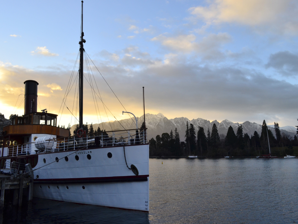


The 150th anniversary celebrations continued into the weekend, coinciding on the same week that the "Lady of the Lake", the TSS Earnslaw celebrated it's 100th birthday. There was also a gold-panning championship over the weekend in Arrowtown, among other events.

One of the horse drawn carriages used in the re-enactment 


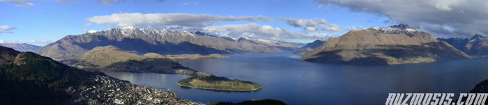
A nice walk to do in Arrowntown is the Tobins track, which starts off by the Arrow River near the recreation reserve. Crossing a wooden bridge over the river, it's a brisk walk to the top where you climb to where it plateaus up at the Crown Terrace. After about 40 mins you reach the top of Tobins Track where there is a trig station and some benches for walkers to have a rest and enjoy the spectacular views of the Wakatipu Basin and the surrounding mountains.

A marker in memory to Thomas Tobin
Tobin built the track as a route to Wanaka


View from Tobins Track looking back over Arrowtown and to Queenstown - click here to view in hi-res


Tuesday, 27 November 2012

The adventure capital of the world

Since we arrived in Dunedin, the time we spent there and in the Catlins wasn't as enjoyable as we hoped for and now we have the added pressure of trying to find a job again having looked at how quickly our funds have run away since leaving Kerikeri - ideally we'll be able to find something that's not beneath most Kiwis but that equally stretches our skills!

But for now, Queenstown is our next destination on the South Island and possibly the one I've been relishing the most since we've arrived in New Zealand. Set in an idyllic spot, Queenstown is surrounded by the soaring peaks of the Remarkables, Ben Lomond and Coronet Peak, and is framed by the endless Lake Wakatipu. It is undoubtedly New Zealand's most popular year-round destination and proudly bears the title of "the adventure capital of the world".

I forgot how much I liked Queenstown and in a way I was hoping that it wouldn't be a case of remembering somewhere with rose-tinted glasses. There's something about the vibe of a small town that has the energy of a big city, where you can tick so many things off your "bucket list". The only slight disappointment has been the amount of rain we've had since the start of our stay.

The mountains of Mordor in Lord of the Rings a.k.a. the Remarkables
William Gilbert Rees, founder of Queenstown
The place where my camera broke 5 years ago!


Lake Wakatipu is the longest lake in New Zealand (at approx. 75km) and the third largest overall in the country. It is also one of the country's deepest lakes, having been carved by a series of glaciers over hundreds and thousands of years - the last of the glaciers began retreating 18,000 years ago. Lake Wakatipu is bordered on all sides by glaciated mountains, the highest of which is Mt Earnslaw (2,830m) near the head of the lake where the Rees and Dart Rivers feed into the lake. Queenstown itself is built on the gravel deposits that the rivers and streams carried along the lake shore.

Lake Wakatipu with the Remarkables, Bayonet Peaks, Cecil Peak and Walter Peak - click here to view in hi-res


Wakatipu is thought to be a shortened form of “Wakatipuwaimaori”, although the meaning is unknown. One of the unique features of Lake Wakatipu is that the water level fluctuates by up to 20cm several times during the day. It is thought that it's caused by variations in temperature and atmospheric pressure, which is a unique feature amongst New Zealand lakes.

Sunrise over Lake Wakatipu and the Remarkables


The steamship TSS Earnshaw has been in service for 100 years


 On 18th October 2012 the Earnslaw will celebrate it's centenary 


For our first proper foray in Queenstown, we took a gondola ride up to Bob's Peak (790m above sea level and 456m above Queenstown), which commands fantastic views over Queenstown, the lake and the Remarkables. The cable car is reputed to be the steepest in the Southern Hemisphere! However, it is possible to walk to the summit of Bob's Peak via the Tiki Trail at the base of the gondola, this takes  roughly an hour zig-zagging up through a pine forest and native bush.

Morning mist drifting over Bob's Peak

The night sky above Bob's Peak


At the top of the gondola there is a viewing deck where you can get 220o degree panoramic views across the Wakatipu basin. Across the eastern shore of the lake the jagged peaks of the Remarkables steeply rise, with the highest point of the range being Double Cone at 2,319m.

If you fancy taking an alternative journey back to the centre of town you can take a tandem paraglide from the top of Bob's Peak. As it was such a nice day, there was a steady stream of people slowly drifting back down to earth, soaking up the amazing views!

The Remarkables rising dramatically above Queenstown

Double Cone at the Remarkables

Coronet Peak (1,651m) is 18km northeast of Queenstown

Looking down on Aspen Lodge where we've been staying


A panoramic view of Queenstown, the Remarkables and Lake Wakatipu - click here to view in hi-res


Bob's Peak is also the setting for the highest bungy in New Zealand, at 400m above Queenstown. We watched a couple of jumps from "The Ledge", but what makes this bungy a little different to the traditional jumps is that you're strapped into a special harness which fits around your waist, so you can twist, flip or dive as you plummet 47m.

That moment when there's no turning back!


View at the Ben Lomond lookout on the Skyline loop track


Our main reason for coming up to Bob's Peak was to ride the Skyline Luge, which we did on Sentosa Island at the Imbiah Lookout in Singapore (you can also do this in Rotorua at Mt Ngongotaha), as both luges are operated by the same company.

Skyline Luge chairlift base


We had two rides on the luge, the first one was on the scenic route which I won by a country mile, but on the advanced route it was a closer affair with Lizzie taking the lead to begin with but I managed to force my way through, only for Lizzie to take it back again in the dying stages of the race...

Gravity is your greatest friend in a luge race!


Lizzie on the viewing deck just before we headed back into town

Twilight over Queenstown


As we didn't have a podium to celebrate our victories, we went to the Below Zero ice bar instead - the largest one in Australasia! Pretty much everything in the bar is made of ice; the walls, the bar, the sculptures, even the furniture and the glasses the cocktails are served in.

I'm sitting on what could be anything...
Lizzie with an ice penguin


An ice sculpture of the jet boat synonymous with Queenstown
At a constant -5o C we had to wear thick jackets and gloves!
The following day we decided to play a round of disc golf in Queenstown Gardens. The rules are simple (as it's played similarly to golf ), all you need are a couple of flying discs and a score card as this is the best way of finding your way round the course. Each "tee" has a par to reach the target in (chain baskets). To finish the hole the disc must end up in the basket or chains. A penalty stroke occurs is your disc lands in a flower bed or if the disc has to be retrieved from the pond or the lake! The game has been played in Queenstown Gardens since the early 1980s and 1996 the Queenstown course became the first permanently marked 18 basket course in New Zealand.

Lizzie by a sign of the Queenstown Gardens Course
 You need to be careful of people crossing the course 
It wasn't as easy to play as it initially sounds, as the golf discs are more difficult to throw than regular frisbees. They're less flexible and made of thicker plastic,which I found out the hard way when one hit me in the shin as we were practicing...

Lizzie teeing off from hole 4
It's hard to believe this is actually a sport


The guy in the shop we rented the discs from mentioned that the flight path of the disc will curve through the air. If thrown backhanded from your right hand the disc will eventually curve to the left, and if you flick your wrist forward it will curve right in the air. I couldn't flick the disc forward with my right hand so I hand to throw the disc backhanded with the left - physics can be very confusing as we also had to take wind speed and direction into account as well!

Rain called a temporary halt to play on the 15th  target, but I eventually went on to win the round, which made up for throwing away the lead in the luge race.

Every time we've walked past Fergburger, no matter the time of day, we've seen queues out the door - it's  open for 21 hours of the day if you need a midnight fix. There's even the Fergbakery next door that only opened last year which mainly sell pies, pastries, sandwiches and cakes. The first thing anyone asks if you mention that you've been to Queenstown is "did you go to Fergburger?", so to indulge our desire for another taste of Ferg's finest (as we'd already been there once before, and saw some of the stars from the Chronicles of Narnia films 5 years ago), Lizzie had the Bun Laden burger (falafel patties dressed with lemon yoghurt and chipolte chilli sauce, lettuce, tomato, red onion, cucumber, avocado and aioli), whilst I had the Cookadoodle Oink (butterflied and crumbed chicken breast, American streaky bacon, avocado, lettuce, tomato, red onion, aioli and tomato relish). It was so busy in the restaurant that we had to eat the burgers back at the hostel. They were burgers of epic proportions, so huge that we were absolutely stuffed when we finished them.


For our first full day where it hadn't chucked it down with rain, we booked a jet boating trip on a great discount website called bookme.co.nz, where we got a half price jet boat ride with Kawarau Jet (KJet)! Commercial jet boating started off in Queenstown back in the 1970s with the Shotover Jet and today there are at least four commercial operators in the area.

The KJet zooming through Queenstown Bay


Arriving at the KJet office on the Main Town Pier, we were given an enormous spray jacket to wear and a life jacket. In a stroke of luck we managed to bagsy some seats right at the front of the boat and the handrail was even heated! After a quick safety talk we were under way as the boat thudded over the waves of the crystal clear Lake Wakatipu, with an occasional 360o or a "Hamilton turn" as they're also known. Taking in the majestic mountains and stunning scenery we headed up towards the Frankton Arm of the lake before zooming under the Kawarau Falls Dam. As we went haring up the Kawarau River (the birthplace of the bungy) the driver made some precariously close shaves with the canyon walls, rocks and low lying tree branches with a couple more 360o spins.

The jet boat spinning part way through a Hamilton Turn


Next the driver took us down the Shotover River, reaching speeds of up to 80km/ hour down a narrow braided river, which is so shallow it reaches less than 10cm deep in places. Because of the way jet boats are propelled, they're able to suck water into the boat and force it out at high pressure so they can operate in really shallow water.

At the end of the ride we got free admission to the Underwater Observatory beneath the jetty. It has six giant windows showcasing life in the lake, including New Zealand finned eels, brown and rainbow trout, and scaup (New Zealand's only true diving ducks) which dive down to collect the food released from a feeder!

New Zealand scaup (Aythya novaeseelandiae) or a black teal


There a number of nice walks you can do in and around Queenstown, especially when the hard-sell on adventure activities gets a bit oppressive, so we opted to do the Queenstown Hill/ Te Tapu-nui (Māori for mountain of intense sacredness) Time Trail, as there are supposed to be fantastic panoramic views from the 907m summit.

Before we even reached the start of track, it was a really steep climb to Belfast Terrace - we were completely shattered before starting the walk! Once we were actually on our way, it was more relentless uphill sections through a cool and dark Douglas fir forest before reaching a lookout over the Frankton section of the lake and the Basket of Dreams sculpture, which was built to commemorate the millennium. From here we had superb views across the lake including the Frankton Arm, the Remarkables range, upper Kawarau River, Cecil Peak,Walter Peak and Queenstown Bay (Tahuna).

Lizzie by the Basket of Dreams by Caroline Robinson

Cecil Peak and Walter Peak across Lake Wakatipu


A little further up is a track to the actual summit, not by the Basket of Dreams! It wasn't much further and it couldn't have taken us more than 15-20 minutes to reach, but it was well worth the views. The whole walk took us just under two and half hours but I think that the local i-SITE should do a better job promoting all the fantastic walks on their doorstep, as their staff hadn't a clue what to recommend...

Not much further to the top, I promise!

A large rock pile which could be mistaken for a shallow grave!

Lizzie pointing our towards the Remarkables and Deer Park Heights

The South Harris Mountain range

 Snow covered mountains as far as the eye could see 


Other views in and around Queenstown:

Looking west up Lake Wakatipu up to Mt Nicholas
Queenstown Bay with Bob's Peak and Bowen Peak
Evening mists descending over Lake Wakatipu
A juvenile Little Pied Cormorant (Microcarbo melanoleucosdrying it's feathers by the lake
Sunset over the Remarkables
Starry night over Cecil Peak