It's with a heavy heart that we have to leave Hawke's Bay to find some work up in the Bay of Islands, in time for the start of the kiwifruit picking season, which runs from April to June. Napier has been our home for the last 5 weeks, and there have a lot of highs and thankfully only a few lows.
We've met some brilliant people at our hostel,
Archie's Bunker (the same hostel we stayed at on our original trip!) and we even managed to find some temporary work, although the whole
apple picking fiasco was the only sour point of our stay. It eventually turned out that despite what you're told, employees are entitled to the minimum wage in New Zealand even on piece rates and if you don't get this then your employer is breaking the law.
For the last three weeks I've been working for
Judd Dougan Team Architects (originally Natusch and Sons), one of the original members of the Associated Architects in Napier who were the principals of the four major architecture practices. It provided an interesting insight into the architecture industry in New Zealand, which isn't dissimilar to the UK in that there has been quite a slow down in the last couple of years, but it's showing signs of recovery from the global recession.
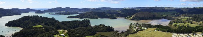
One of the last things we did on our final weekend in Hawke's Bay was to scale Te Mata peak, located a short distance from Napier (25 km away) on the outskirts of Havelock North. Legend tells us that the ridge is meant to be the body of the Māori chief, Rongokako, lying down after having choked on a rock as he tried to eat his way through the hill. At the very top of the peak you can get beautiful panoramic views across the Heretaunga Plains - on a clear day it's supposedly possible to see Mt Ruapehu in the heart of Tongariro National Park.
 |
| Lizzie in front of the 399m high limestone bluffs
|
 |
| View looking back to Napier
|
Hopefully we'll be back in Napier before too long, but for now Kerikeri is our ultimate destination as we head up to the most northern region of the North Island to check out the much touted
Bay of Islands. Famous for its sub-tropical weather and beautiful blue waters with around 150 islands punctuated throughout, the area also holds enormous historical significance for the Māori as well as the first Europeans who settled here, when the British started colonising
Aotearoa or New Zealand as it's now known.

Driving north of Napier along the Thermal Explorer Highway (State Highway 5) where we stopped off in Rotorua via Taupo to see some familiar sites at
Kuirau Park (a public park with lots of geothermal activity) and down by Lake Rotorua - the second largest lake on the North Island.
Continuing along State Highway 5, we eventually stopped off at Hamilton to break up the journey and spend the night there, although I can't say I was impressed by the small part of Hamilton we saw and I don't think we'll bother making a return trip!
 |
| Kuirau Park is a good place to see free geothermal activity in Rotorua |
The next day we left early to drive up the motorway through Auckland, as it was still another 5 hours to Kerikeri. Taking a brief detour to avoid the Northern Gateway Toll Road, we briefly joined the Hibiscus Coast Highway where we stopped off in Orewa for lunch. From there we drove State Highway 1 all the way up to Kerikeri for roughly 210 kms.
The place we're staying at is on the outskirts of the town, called
Kerikeri Farm Hostel. It's an animal lovers paradise so Lizzie feels very much at home! There are two dogs at the hostel, a one year old Labrador called Nika - she's a lovely dog who's very excitable but also likes to jump up at you and chew your hand if she gets too carried away! There's also another dog called Weewee who is a little older and very affectionate, although she's a little overweight and is currently on a diet. Apparently, there's an elusive cat around called Mr Stink, however he's quite shy and we haven't seen him yet.
 |
| Throw Nika a stick and she'll be your new best friend
|
 |
| Weewee loves her back being scratched!
|
The farm hostel also has two female kunekune pigs (which means 'fat and round' in Māori), a sheep called "Fluffy" and a whole host of free range chickens, which are quite tame and friendly.
 |
| These were once cute little piglets. Oink oink! |
 |
| The cockerel is a reliable morning alarm clock |
 |
| This chicken wouldn't look out of place in the film Tron! |
Exploring the local area we ventured 2 km from town down to the Kerikeri Basin, which was the site chosen by Samual Marsden for the Church Missionary Society's second mission in New Zealand. The site is home to New Zealand's oldest standing European buildings - the Stone Store and Kerikeri Mission House (Kemp House). The Stone Store is the oldest surviving stone building in New Zealand and was constructed in 1836 - it kind of reminds me of the old wool mill buildings back at home in Witney, Oxfordshire. The store served as a central provision store for the Church Missionary Society. Nearby is Kemp House, which is New Zealand's oldest European building constructed between 1820-21. Although, it's less than 200 years old, Kemp House still pre-dates the signing of the Treaty of Waitangi (New Zealand's founding document) by almost 20 years.
 |
| The old Stone Store across the Kerikeri River |
 |
| More info about what the store was used for can be found inside |
Opposite the Kerikeri Basin Reserve is the start of a walk along the Kerikeri River to Wharepuke Falls, where we got an awesome view of a Sacred Kingfisher (
Todiramphus sanctus).
 |
| A Pukeko (New Zealand Swamp Hen) on the opposite side of the river |
 |
| The Kingfisher is also known by its Māori name, Kōtare |
|
 |
| Wharepuke Falls are a 20 minute walk from the Stone Store |
The track follows the north bank of the river, passing through some kiwi habitat and regenerating native trees such as kauri and tōtara. Further up the river are Rainbow Falls (or Waianiwaniwa, which in Māori means "Waters of the Rainbow"), which are 27m high. There's a decent lookout from the top and the falls certainly lived up to their name as there were lots of rainbows created by all the mist in the air. It's possible to walk to the base of the falls but you are guaranteed to get a little damp from all the water vapour drifting in the air!
 |
| A rainbow formed from the spray of Rainbow Falls |
 |
| There's no safety barriers to stop you falling in if you get too close! |