Showing posts with label Napier. Show all posts

Monday, 27 August 2012

Crossing the Cook Strait

Having spent almost four months on the North Island (Te Ika a Maui), it's time for us to move on and venture onto the larger but more sparsely populated South Island (Te Wai Pounamu), which is renowned for it's spectacular natural beauty including breathtaking mountains, numerous lakes and true wildernesses, as well as comparatively colder winters!

However, before booking our ticket to catch the Interislander ferry from Wellington, there was time for us to quickly pass through Taupō to see Mt Ruapehu at the southern shore of the lake in all it's glory. When we were here in February we couldn't see the volcano, so it was quite a spectacular sight to behold with the snow on it's peaks.

Mt Ruapehu is the North Island's highest mountain

The mountain is actually an active stratovolcano!


We also planned to drop into Napier to catch up with some friends and to do a small amount of work, as well as for Lizzie to do some volunteering at the SPCA (Society for the Prevention of Cruelty to Animals).

The drive from Napier down to the Interislander Ferry Terminal in Wellington is quite lengthy (over 300 km), so normally we would have stayed somewhere closer to Wellington or even in the capital itself, but it's more expensive to stay there than anywhere else in the country. If we did decide to stay in Wellington then we would have liked to have been there for a couple of nights so we could see some of the sights, but we're just keen to get onto the South Island now as we've spent more time on the North Island than we had in the whole of New Zealand the last time we were here.

Starting off at 7am (yes, it's bloody early but we needed to be at the ferry terminal for 1.30pm) we drove through Hastings out towards the beautiful mountain ranges of Central Hawke's Bay at Ongaonga alongside the Ruahine Forest Park. Passing through Southern Hawke's Bay on State Highway 2 there were a relentless number of sheep and cattle stations but there was little of genuine interest. At Mangatainoka we drove past the famous Tui Brewery and the "Frank the Tank" grain silo at Mangatainoka.

Continuing on our journey, we stopped off very briefly in Carterton in South Wairarapa, the namesake of the nearest town to us back at in home in Witney! Unfortunately, there's not much to write home about (a bit like back in England) for the self-proclaimed Daffodil capital of New Zealand but it's funny to think of friends back in Carterton, Oxfordshire 11,700 miles away.
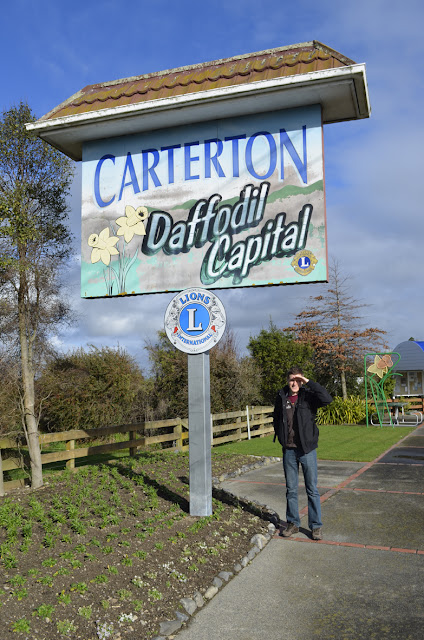
This is for Ben and Aaron back in Oxfordshire!
The most nerve-racking part of the drive journey was the section between Greytown and Upper Hutt at Rimutaka Hill as the road climbed (extremely) steeply through Tararua Forest Park - as Lizzie was the passenger she was hoping that I was concentrating on my driving, but for me the biggest concern was that the petrol gauge was hovering above empty. Being in the middle of nowhere I couldn't think of a worse place to run of out petrol but it wasn't all doom and gloom as the dregs of the petrol tank were giving a bit of a false reading on the steep inclines, so once we were back driving downhill the gauge looked a little healthier!

Once we arrived at the ferry terminal we waited for over an hour and a half before the ferry finally left Wellington despite being warned to arrive in good time before the final check-in. We were so bored waiting to board the ferry I decided to go for a nap in the car but before long as I was being rudely awaken by Lizzie as the vehicles were boarding the ferry and we were holding up the queue!

It's quite expensive to take a car on the ferry but we were able to get a discount through booking a non-refundable web saver fare and a additional 10% off using our BBH backpacker club cards.

Lizzie with the Lancer at the windy ferry terminal


Wellington Harbour (Te Whanganui-a-Tara or Port Nicholson as it's technically known) is a large natural harbour surrounded by hills and with a narrow entrance to the sea guarded by the Barrett Reef. In Māori tradition the explorer Kupe is said to be the first person to visit the harbour. Our ferry for sailing across the Cook Strait (Raukawakawa) was the Aratere (or Māori for "quick path") which was recently lengthened in Singapore in 2011:


The Cook Strait connects the South Pacific Ocean and the Tasman Sea through the centre of the New Zealand land mass. Great oceanic currents sweep up the coast of the South Island and funnel through the channel between Cape Terawhiti on the North Island and Arapawa Island at the entrance to the South Island's Marlborough Sounds. As a result of the strong swells, the crossing is famous for being quite rough, although we must have been quite fortunate as it was a relatively smooth journey.

Entering the drowned valleys of Marlborough Sounds through the Tory Channel, our final destination was the sleepy town of Picton in heart of the Marlborough Sounds. Unfortunately, it had got too dark for us to see any of the Queen Charlotte Sound, so we might have to save this for the return journey! Picton is a good base to tackle the Queen Charlottle Track - supposedly one of the best walks to do in New Zealand, however, it was something we never did when we were in the Marlborough region five years ago.

The bow of the Aratere heading for the Marlborough Sounds

Arapawa Island on the horizon

Sunset over the Marlborough Sounds


The journey across the Cook Strait brings an end to our travels in North Island but the map below highlights all the places we've visited.

The yellow dots represent all the places we've visited and the red dots the places stayed 


Tuesday, 17 April 2012

Up to the Bay of Islands

It's with a heavy heart that we have to leave Hawke's Bay to find some work up in the Bay of Islands, in time for the start of the kiwifruit picking season, which runs from April to June. Napier has been our home for the last 5 weeks, and there have a lot of highs and thankfully only a few lows.

We've met some brilliant people at our hostel, Archie's Bunker (the same hostel we stayed at on our original trip!) and we even managed to find some temporary work, although the whole apple picking fiasco was the only sour point of our stay. It eventually turned out that despite what you're told, employees are entitled to the minimum wage in New Zealand even on piece rates and if you don't get this then your employer is breaking the law.

For the last three weeks I've been working for Judd Dougan Team Architects (originally Natusch and Sons), one of the original members of the Associated Architects in Napier who were the principals of the four major architecture practices. It provided an interesting insight into the architecture industry in New Zealand, which isn't dissimilar to the UK in that there has been quite a slow down in the last couple of years, but it's showing signs of recovery from the global recession.

One of the last things we did on our final weekend in Hawke's Bay was to scale Te Mata peak, located a short distance from Napier (25 km away) on the outskirts of Havelock North. Legend tells us that the ridge is meant to be the body of the Māori chief, Rongokako, lying down after having choked on a rock as he tried to eat his way through the hill. At the very top of the peak you can get beautiful panoramic views across the Heretaunga Plains - on a clear day it's supposedly possible to see Mt Ruapehu in the heart of Tongariro National Park.

Lizzie in front of the 399m high limestone bluffs


View looking back to Napier


Hopefully we'll be back in Napier before too long, but for now Kerikeri is our ultimate destination as we head up to the most northern region of the North Island to check out the much touted Bay of Islands. Famous for its sub-tropical weather and beautiful blue waters with around 150 islands punctuated throughout, the area also holds enormous historical significance for the Māori as well as the first Europeans who settled here, when the British started colonising Aotearoa or New Zealand as it's now known.

Driving north of Napier along the Thermal Explorer Highway (State Highway 5) where we stopped off in Rotorua via Taupo to see some familiar sites at Kuirau Park (a public park with lots of geothermal activity) and down by Lake Rotorua - the second largest lake on the North Island.

Continuing along State Highway 5, we eventually stopped off at Hamilton to break up the journey and spend the night there, although I can't say I was impressed by the small part of Hamilton we saw and I don't think we'll bother making a return trip!

Kuirau Park is a good place to see free geothermal activity in Rotorua


The next day we left early to drive up the motorway through Auckland, as it was still another 5 hours to Kerikeri. Taking a brief detour to avoid the Northern Gateway Toll Road, we briefly joined the Hibiscus Coast Highway where we stopped off in Orewa for lunch. From there we drove State Highway 1 all the way up to Kerikeri for roughly 210 kms.

The place we're staying at is on the outskirts of the town, called Kerikeri Farm Hostel. It's an animal lovers paradise so Lizzie feels very much at home! There are two dogs at the hostel, a one year old Labrador called Nika - she's a lovely dog who's very excitable but also likes to jump up at you and chew your hand if she gets too carried away! There's also another dog called Weewee who is a little older and very affectionate, although she's a little overweight and is currently on a diet. Apparently, there's an elusive cat around called Mr Stink, however he's quite shy and we haven't seen him yet.

Throw Nika a stick and she'll be your new best friend

Weewee loves her back being scratched!


The farm hostel also has two female kunekune pigs (which means 'fat and round' in Māori), a sheep called "Fluffy" and a whole host of free range chickens, which are quite tame and friendly.

These were once cute little piglets. Oink oink!

The cockerel is a reliable morning alarm clock


This chicken wouldn't look out of place in the film Tron!


Exploring the local area we ventured 2 km from town down to the Kerikeri Basin, which was the site chosen by Samual Marsden for the Church Missionary Society's second mission in New Zealand. The site is home to New Zealand's oldest standing European buildings - the Stone Store and  Kerikeri Mission House (Kemp House). The Stone Store is the oldest surviving stone building in New Zealand and was constructed in 1836 - it kind of reminds me of the old wool mill buildings back at home in Witney, Oxfordshire. The store served as a central provision store for the Church Missionary Society. Nearby is Kemp House, which is New Zealand's oldest European building constructed between 1820-21. Although, it's less than 200 years old, Kemp House still pre-dates the signing of the Treaty of Waitangi (New Zealand's founding document) by almost 20 years.

The old Stone Store across the Kerikeri River


More info about what the store was used for can be found inside


Opposite the Kerikeri Basin Reserve is the start of a walk along the Kerikeri River to Wharepuke Falls, where we got an awesome view of a Sacred Kingfisher (Todiramphus sanctus).

A Pukeko (New Zealand Swamp Hen) on the opposite side of the river

The Kingfisher is also known by its Māori name, Kōtare 


Wharepuke Falls are a 20 minute walk from the Stone Store 


The track follows the north bank of the river, passing through some kiwi habitat and regenerating native trees such as kauri and tōtara. Further up the river are Rainbow Falls (or Waianiwaniwa, which in Māori means "Waters of the Rainbow"), which are 27m high. There's a decent lookout from the top and the falls certainly lived up to their name as there were lots of rainbows created by all the mist in the air. It's possible to walk to the base of the falls but you are guaranteed to get a little damp from all the water vapour drifting in the air!


A rainbow formed from the spray of Rainbow Falls


There's no safety barriers to stop you falling in if you get too close!

Thursday, 29 March 2012

In and around Hawke's Bay: Hastings

Located 20km south of Napier is the town of Hastings, which is the commercial hub of Hawke's Bay. The district has a long history as a food producing region and it and is commonly referred to as the "Fruit Bowl of New Zealand", in particular for its strong associations with growing stone fruits and wine production.

Although it's the bigger brother to Napier, Hastings also shares a rich architectural heritage as much of it was also devastated by the 1931 Hawke's Bay earthquake. Whilst it didn't sustain quite the same level of devastation inflicted on its twin city, Hastings was also rebuilt to reflect the styles of the times - Stripped Classical, Spanish Mission and Art Deco. Where Art Deco is king in Napier, Spanish Mission has the upper hand in Hastings. In particular, the Westerman's Building (1932) is considered one of the best Spanish Mission style buildings in Hawke's Bay, rivalling that of the Criterion Hotel.

The magnificent Westerman's Building is home to the visitor centre

Decorative leadlights under the verandah


Picking up a couple of leaflets from i-SITE we decided to do some self-guided walks to explore the Central Business District. The most obvious building to begin with is the Clock Tower (1935), which towers over the city square. Art Deco in style, the tower was designed by young local architect Sydney Chaplin, who won a national design competition in 1934. The main Post Office with its clock tower was one of the main buildings to be destroyed  in the 1931 earthquake, so as part of the reconstruction efforts, a new clock tower was identified as one of the priorities. The Clock Tower is one of many buildings in Hastings registered with the New Zealand Historic Places Trust and serves as both a landmark and as a memorial to the 93 Hastings's residents who died in the earthquake.


On the edge of the city square is the Haukanui water feature, which is described as a point which serves as a link between the east and west ends of Hastings. Haukanui means "life giving waters" and apparently the feature symbolises the abundant natural water resource of the local aquifer system. However, I can't say that I've been to too many places where freight trains run through the middle of a fountain!

A picture of calmness and serenity at the Hastings city square...

... is shattered by a filthy, great big freight train


Walking west of the railway line we walked past some notable buildings including the Heretauga Club (1936), Medical and Dental Chambers (1935), Villa d' Este (1929) and Roach's Department Store (1934), among other buildings of interest.

The initials of the Heretauga Club can be seen on the exterior

The streamline Medical and Dental Chambers has curved walls projecting from the façade at each end
The most distinctive feature is the triangle-shaped window projecting  above the entrance
Villa d'Este on Heretaunga Street
The former Roach's Department Store
The Russell Street precinct has some of the most stunning Spanish Mission style buildings in Hastings, such as the CML (1939), Harvey's (1933) and Fitzpatrick's (1924) buildings. The CML Building was the last significant pre-World War II heritage building constructed in Hastings.

The Colonial Mutual Life (CML) Assurance Building is an eclectic mix of Art Deco, Spanish Mission and Stripped Classical styles
Decorative motifs of Maori origin are an unusual feature in the archway
The Harvey's Building is currently home to the Hastings Community Art Centre and inside there is an impressive leadlight skylight which fills the gallery with natural light.

The Spanish Mission Harvey's Building on Russell Street
The impressive leadlight design above the main gallery


Green Celtic knots can be seen in the design on the pilasters of the Fitzpatrick's Building
The Hastings Post Office was originally built in 1910 and extended in 1928. However, only the extension survived the earthquake. This was incorporated in a new Stripped Classical building designed by J.T. Muir who also designed the Former Government Buildings in Napier.

The former Hastings Post Office is one of the best known and historically important buildings in Hastings
The Stripped Classical design has subtle ionic decoration

The Former Government Buildings in Napier
The cream of crop of Hastings' heritage buildings is the Hastings Municipal Theatre (1915) which forms part of the Hawke's Bay Opera House. This was the first Spanish Mission building façade to be completed in Hastings. While the building survived the earthquake, extensive repairs and strengthening were required. Adjoining the Municipal Theatre is the Muncipal Building and Assembly Hall (1917). The building was designed by local architect Albert Garnett who won a design competition, which neighbouring Napier architects banned from entering. He drew on an eclectic blend of visual styles to design a Renaissance-style building for the Hastings Borough Council's administration staff.

The Municipal Theatre is one of the last remaining theatres in New Zealand built by the eminent Australasian theatre designer Henry Eli White
The leadlight glass at the Hastings St side entrance is Art Nouveau in style
In 2004, the District Council commissioned the restoration of these two heritage buildings and a new third building comprising of a foyer and plaza linking the Opera House to the existing historical buildings.

The Municipal Buildings also house Hawke's Bay's largest ballroom as part of the Opera House complex


Opposite the Opera House is the Wesley Methodist Church (1932) which completes this iconic part of Hastings. This Spanish Mission style church was designed to replace the original, which was destroyed by the 1931 earthquake. The redeveloped site contains stone seats and a low perimeter stone wall, which are constructed from the concrete rubble recovered from the original Methodist church.

Wesley Methodist Church is set across the road from the Opera House
The outside of the church has been painted in colours to complement the Opera House
Finally, the Dominion Restaurant (1935) on Heretaunga Street is the only remaining asymmetrical shop front design in Hastings. Although Hastings was predominately rebuilt in the Spanish Mission style architecture, this is most definitely Art Deco!

The Dominion Restaurant was designed by the prominent the architecture practice Edmund Anscombe and Associates.
Although, we enjoyed doing our own tour round Hastings it definitely felt more rough around the edges than Napier, especially with all the boy racers. I would recommend it as good day trip if you're looking for some more unique architecture. Hastings was less than an hour away from Napier on the bus, which is considered a good connection if your using public transport in the more remote parts of New Zealand.