Having spent the best part of yesterday trying to second guess the weather, deciding whether or not to walk the Queen Charlotte Track, we woke up at 8am and it wasn't looking good as it had been raining the night before and looked really overcast. I was a bit gutted initially as I felt the cost of the water taxi was quite steep for a self-guided walk, so good weather was a definite requirement as the Queen Charlotte Track is reputed to be one of the top ten and finest coastal walking tracks in New Zealand.
The plan for the day was to be dropped off at Ship Cove and walk along a section of the Queen Charlotte Track to Endeavour Inlet where we would be picked up again by the water taxi. The stretch of the track we're walking is approximately 15km long, although the entire track is 71km in length which can be done in 3-5 days of tramping (staying in overnight accommodation along the way).
The Queen Charlotte Sound is the best known of the three Sounds (Pelorus Sound and Kenepuru Sound are the other two) and is a labyrinth of drowned valleys enclosed by moody picturesque bays, deserted sandy coves and islands. The journey up Queen Charlotte Sound (Totaranui) from Picton to Ship Cove (Meretoto) took roughly an hour, although the last 20 minutes of the trip were a little choppier as we were going through the swell.
Looking from Picton Habour towards the Queen Charlotte Sound
The bush clad shoreline of the Queen Charlotte Sound
The numerous bays, coves and islands of the Sound
On 16th January 1770, the Endeavour, under the command of the then Lieutenant James Cook, dropped anchor in the bay which he would name Ship Cove. This would be the first of several visits by ships under Cook's command on his three voyages. He spent more time here than anywhere else in New Zealand and it was the first place that sustained contact between the Māori and the British took place. The Māori were keen to trade for European goods while Cook's crew observed and engaged in the Māori culture and way of life.
Captain Cook had explored more of the earth's surface than anyone else before him in history and became the first European to land in New Zealand and the east coast of Australia. However, it was Cook's travels that spurred on the colonisation of the Pacific, which brought with it missionaries, whalers, traders, settlers and even death, and ultimately impacted on Pacific Island cultures. As a result, many indigenous cultures detest Cook for his achievements as they view him as the villain who introduced disease, dispossession and other ills to the Pacific.
Whatever view you hold, Captain James Cook remains one of the most significant figures in the shaping of the modern Pacific.
View of Motuara Island from Ship Cove
A large concrete monument commemorates Captain Cook's visits.
It's easy to see why Ship Cove was one of Cook's favourite places
Crossing the stream at Ship Cove
Māori carvings welcome visitors to the cove
From here the reserve is the starting point for everyone walking the Queen Charlotte Track, which is actually part of Te Araroa(the long pathway) - a walking trail from Cape Rēinga all the way down to Bluff, which opened on 3rd December 2011. Heading south from the Cook monument, the first couple of kilometers of the track were undulating with quite a steep initial climb. It must have rained a lot overnight as the track was quite boggy and damp underfoot, and the clay slopes were really slippery. At one point a fallen tree had completely blocked the path - it must have fallen quite recently as the branches looked freshly broken.
A deep canopy shades the profusion of tree ferns and other vegetation
One of the many streams crossing the track
After about 45 minutes of walking we reached a lookout that offered pleasant respite and good views of Motuara Island and the outer Queen Charlotte Sound. It was from Motuara Island that James Cook declared sovereignty over the South Island. Cook also renamed Totaranui the Queen Charlotte Sound in honour of King George III's consort. Today, Motuara Island is a bird sanctuary for the South Island robin and the South Island saddle back. It was also round by the lookout that we got our first view of an inquisitive Weka (Gallirallus australis) in the bushes!
Motuara Island on the left and Hippo Island on the right
View over Resolution Bay with Tawa Bay Saddle on the far right
You can just about make out the snowcapped KaikōuraMountains
From here we climbed the Ship Cove/ Resolution Bay Saddle and descended towards Resolution Bay. However, it was a bit disappointing that we couldn't get down close to Resolution Bay itself as we unsure of where the trail would take us if we went off the beaten track, due to a lack of signage.
From Resolution Bay the track followed an old bridle path ascending over a ridge, which would eventually lead down into Endeavour Inlet. The inclining track passed through stands of kamahi and then beech forest as we passed over another saddle.
Some more of the native vegetation of the track
Every now and again you get glimpse of the sea through the tree line
Climbing up the ridge overlooking Resolution Bay
We were literally the only people on the section of track we walked - in the middle of nowhere with no mobile phone coverage! We were surprised when we eventually saw someone walking their dogs. At times it was very tranquil and silent when you paused to take in the solitude of the surroundings, apart from the occasional chirp of a bird or when the trees swayed in the wind. This was shattered as at one point when Lizzie comically fell into a small stream we had to cross and got quite cold and wet in the process!
A sad Lizzie after she stumbled on a loose rock in the stream!
A crystal clear stream that eventually feeds into the Sound
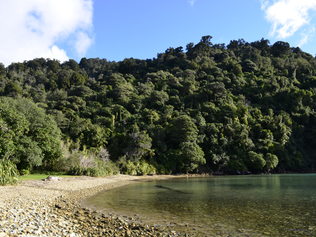
Resolution Bay looking back towards Ship Cove
As mentioned previously, we saw quite a few Wekas (or woodhens) along the walk - they look like a cross between a moorhen and a duck. This flightless bird is a little like a kiwi but slimmer and far less shy. The one we saw was especially tame as it was foraging very close to us in the bush.
This bold Weka didn't have any problems with getting close to us
Wekas are famous for their feisty and curious personalities
As nice a walk as the Queen Charlotte Track was to do, it was difficult to judge the progress we were making along the track as there were no markers and very few useful signs. Our final destination was Furneaux Lodge at the head of Endeavour Inlet on the eastern side of the bay. The last section of the walk involved us walking through a lots of regenerating native bush, with a predominance of manuka, kanuka and five finger vegetation.
Endeavour Inlet was one of Captain Cook's favourite anchorages
This is first time we'd been able to get to the shore since Ship Cove
On the whole I'm glad to have done the walk as it offered stunning views of the Marlborough Sounds but I wouldn't say it was an essential thing to go out of your way to do unless you happen to be in Picton or are passing through the Marlborough Region. In total, it took us 4 hours 50 minutes to do the walk from Ship Cove to Endeavour Inlet, including stops for lunch, climbing over a mini obstacle course and taking plenty of photos!
One of several storm damaged trees blocking out path
There's no turning back now...
Lizzie having a well earned beer in Furneaux Lodge
We were a little disappointed that we didn't see any dolphins in the Sounds on our journey via the water taxi, but at least we were able to walk the track in the first place, so I guess you can't have it all!
Having spent almost four months on the North Island (Te Ika a Maui), it's time for us to move on and venture onto the larger but more sparsely populated South Island (Te Wai Pounamu), which is renowned for it's spectacular natural beauty including breathtaking mountains, numerous lakes and true wildernesses, as well as comparatively colder winters!
However, before booking our ticket to catch the Interislander ferry from Wellington, there was time for us to quickly pass through Taupō to see Mt Ruapehu at the southern shore of the lake in all it's glory. When we were here in February we couldn't see the volcano, so it was quite a spectacular sight to behold with the snow on it's peaks.
Mt Ruapehu is the North Island's highest mountain
The mountain is actually an active stratovolcano!
We also planned to drop into Napier to catch up with some friends and to do a small amount of work, as well as for Lizzie to do some volunteering at the SPCA(Society for the Prevention of Cruelty to Animals).
The drive from Napier down to the Interislander Ferry Terminal in Wellington is quite lengthy (over 300 km), so normally we would have stayed somewhere closer to Wellington or even in the capital itself, but it's more expensive to stay there than anywhere else in the country. If we did decide to stay in Wellington then we would have liked to have been there for a couple of nights so we could see some of the sights, but we're just keen to get onto the South Island now as we've spent more time on the North Island than we had in the whole of New Zealand the last time we were here.
Starting off at 7am (yes, it's bloody early but we needed to be at the ferry terminal for 1.30pm) we drove through Hastings out towards the beautiful mountain ranges of Central Hawke's Bay at Ongaonga alongside the Ruahine Forest Park. Passing through Southern Hawke's Bay on State Highway 2 there were a relentless number of sheep and cattle stations but there was little of genuine interest. At Mangatainoka we drove past the famous Tui Brewery and the "Frank the Tank" grain silo at Mangatainoka.
Continuing on our journey, we stopped off very briefly in Carterton in South Wairarapa, the namesake of the nearest town to us back at in home in Witney! Unfortunately, there's not much to write home about (a bit like back in England) for the self-proclaimed Daffodil capital of New Zealand but it's funny to think of friends back in Carterton, Oxfordshire 11,700 miles away.
This is for Ben and Aaron back in Oxfordshire!
The most nerve-racking part of the drive journey was the section between Greytown and Upper Hutt at Rimutaka Hill as the road climbed (extremely) steeply through Tararua Forest Park - as Lizzie was the passenger she was hoping that I was concentrating on my driving, but for me the biggest concern was that the petrol gauge was hovering above empty. Being in the middle of nowhere I couldn't think of a worse place to run of out petrol but it wasn't all doom and gloom as the dregs of the petrol tank were giving a bit of a false reading on the steep inclines, so once we were back driving downhill the gauge looked a little healthier!
Once we arrived at the ferry terminal we waited for over an hour and a half before the ferry finally left Wellington despite being warned to arrive in good time before the final check-in. We were so bored waiting to board the ferry I decided to go for a nap in the car but before long as I was being rudely awaken by Lizzie as the vehicles were boarding the ferry and we were holding up the queue!
It's quite expensive to take a car on the ferry but we were able to get a discount through booking a non-refundable web saver fare and a additional 10% off using our BBH backpacker club cards.
Lizzie with the Lancer at the windy ferry terminal
Wellington Harbour (Te Whanganui-a-Tara or Port Nicholson as it's technically known) is a large natural harbour surrounded by hills and with a narrow entrance to the sea guarded by the Barrett Reef. In Māori tradition the explorer Kupe is said to be the first person to visit the harbour. Our ferry for sailing across the Cook Strait (Raukawakawa) was the Aratere (or Māori for "quick path") which was recently lengthened in Singapore in 2011:
The Cook Strait connects the South Pacific Ocean and the Tasman Sea through the centre of the New Zealand land mass. Great oceanic currents sweep up the coast of the South Island and funnel through the channel between Cape Terawhiti on the North Island and Arapawa Island at the entrance to the South Island's Marlborough Sounds. As a result of the strong swells, the crossing is famous for being quite rough, although we must have been quite fortunate as it was a relatively smooth journey.
Entering the drowned valleys of Marlborough Sounds through the Tory Channel, our final destination was the sleepy town of Picton in heart of the Marlborough Sounds. Unfortunately, it had got too dark for us to see any of the Queen Charlotte Sound, so we might have to save this for the return journey! Picton is a good base to tackle the Queen Charlottle Track - supposedly one of the best walks to do in New Zealand, however, it was something we never did when we were in the Marlborough region five years ago.
The bow of the Aratere heading for the Marlborough Sounds
Arapawa Island on the horizon
Sunset over the Marlborough Sounds
The journey across the Cook Strait brings an end to our travels in North Island but the map below highlights all the places we've visited.
The yellow dots represent all the places we've visited and the red dots the places stayed